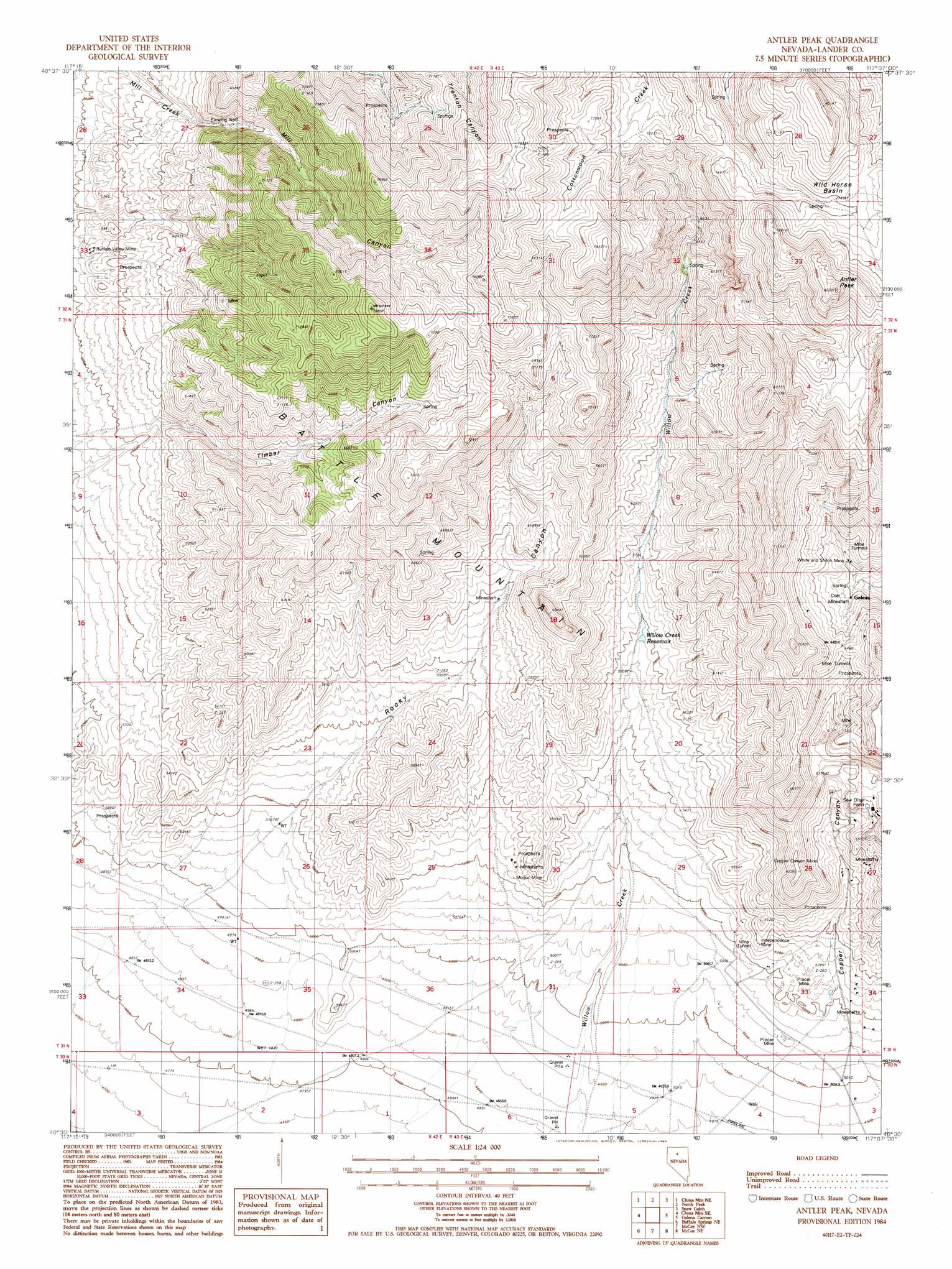
Antler Peak Topo Map Nevada
To zoom in, hover over the map of Antler Peak
USGS Topo Quad 40117e2 - 1:24,000 scale
| Topo Map Name: | Antler Peak |
| USGS Topo Quad ID: | 40117e2 |
| Print Size: | ca. 21 1/4" wide x 27" high |
| Southeast Coordinates: | 40.5° N latitude / 117.125° W longitude |
| Map Center Coordinates: | 40.5625° N latitude / 117.1875° W longitude |
| U.S. State: | NV |
| Filename: | o40117e2.jpg |
| Download Map JPG Image: | Antler Peak topo map 1:24,000 scale |
| Map Type: | Topographic |
| Topo Series: | 7.5´ |
| Map Scale: | 1:24,000 |
| Source of Map Images: | United States Geological Survey (USGS) |
| Alternate Map Versions: |
Antler Peak NV 1984, updated 1984 Download PDF Buy paper map Antler Peak NV 1984, updated 1984 Download PDF Buy paper map Antler Peak NV 2011 Download PDF Buy paper map Antler Peak NV 2014 Download PDF Buy paper map |
1:24,000 Topo Quads surrounding Antler Peak
Goldrun Creek |
Brooks Spring |
Valmy |
Ellison |
Russells |
Smelser Pass |
China Mountain Ne |
North Peak |
Snow Gulch |
Battle Mountain |
China Mountain |
China Mountain Se |
Antler Peak |
Galena |
Blossom Spring |
Buffalo Springs |
Buffalo Springs Ne |
Mccoy Nw |
Mccoy Ne |
Crippen Canyon |
Jersey Summit |
Wild Range Canyon |
Mccoy |
Redrock Spring |
Goat Peak |
> Back to 40117e1 at 1:100,000 scale
> Back to 40116a1 at 1:250,000 scale
> Back to U.S. Topo Maps home
Antler Peak topo map: Gazetteer
Antler Peak: Basins
Wild Horse Basin elevation 2251m 7385′Antler Peak: Mines
Big Nugget Mine elevation 1795m 5889′Black Rock Mine elevation 1985m 6512′
Blossom Mine elevation 1922m 6305′
Bon Ami Mine elevation 1960m 6430′
Buena Vista Mine elevation 1900m 6233′
Buffalo Valley Mine elevation 1719m 5639′
Copper Canyon Mine elevation 1746m 5728′
D and E Mine elevation 1817m 5961′
Dahl Placer elevation 1611m 5285′
Dead Horse Mine elevation 1855m 6085′
Eldorado Mine elevation 1611m 5285′
Elko-Lander Mine elevation 1864m 6115′
Estis Mine elevation 1690m 5544′
Gold Crown Mine elevation 1793m 5882′
Gold Crown Placer Mine elevation 1753m 5751′
Greenan Placers Mine elevation 1559m 5114′
Guy Davis Mine elevation 1754m 5754′
Hard Times Mine elevation 2033m 6669′
Homestake Consolidated Mine elevation 1776m 5826′
Independence Mine elevation 1645m 5396′
Marion Mine elevation 1903m 6243′
Meagher Mine elevation 1986m 6515′
Modoc Mine elevation 1603m 5259′
Natomas Placers elevation 1608m 5275′
Nevada Mine elevation 1921m 6302′
Nicklas Mine elevation 1935m 6348′
Oversight Mine elevation 1663m 5456′
Palisades Mine elevation 1914m 6279′
Sunrise Fraction Mine elevation 1687m 5534′
Superior Lease Mine elevation 1683m 5521′
Telluride Mine elevation 2150m 7053′
Trenton Mine elevation 2121m 6958′
Virgin and Superior Mine elevation 1737m 5698′
Weber Gulch Mine elevation 1699m 5574′
White elevation 1910m 6266′
White and Shiloh Mine elevation 1890m 6200′
Wilson Independence Mine elevation 1662m 5452′
Antler Peak: Populated Places
Blanco (historical) elevation 1884m 6181′Galena (historical) elevation 1877m 6158′
Telluride (historical) elevation 1751m 5744′
Antler Peak: Post Offices
Copper Canyon Post Office (historical) elevation 1588m 5209′Galena Post Office (historical) elevation 1877m 6158′
Antler Peak: Reservoirs
Willow Creek Reservoir elevation 1698m 5570′Antler Peak: Summits
Antler Peak elevation 2463m 8080′Antler Peak: Valleys
Copper Canyon elevation 1522m 4993′Mill Canyon elevation 1804m 5918′
Rocky Canyon elevation 1528m 5013′
Timber Canyon elevation 1745m 5725′
Willow Canyon elevation 1489m 4885′
Antler Peak digital topo map on disk
Buy this Antler Peak topo map showing relief, roads, GPS coordinates and other geographical features, as a high-resolution digital map file on DVD: