Mitchell Gulch Topo Map California
To zoom in, hover over the map of Mitchell Gulch
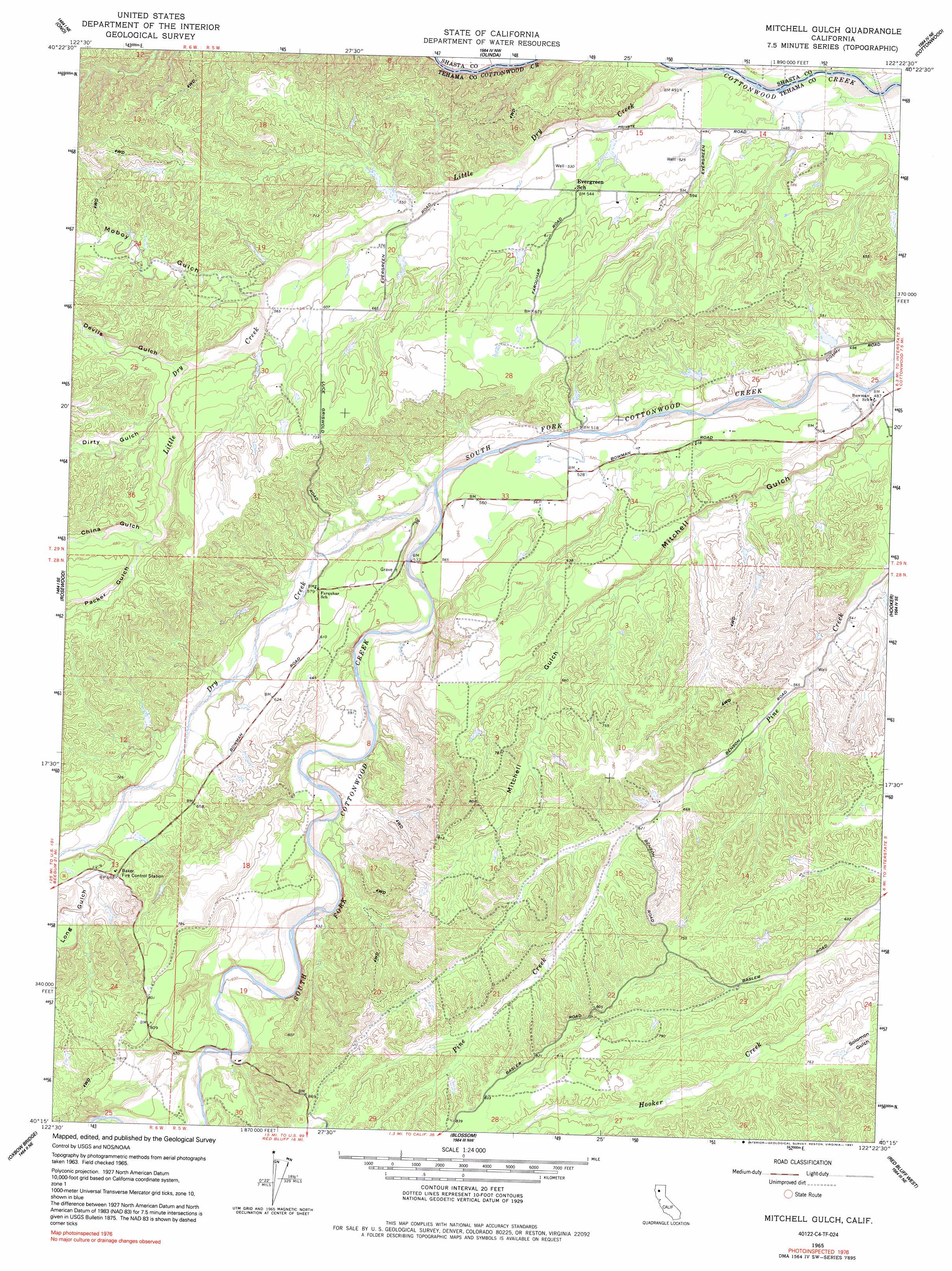
USGS Topo Quad 40122c4 - 1:24,000 scale
| Topo Map Name: | Mitchell Gulch |
| USGS Topo Quad ID: | 40122c4 |
| Print Size: | ca. 21 1/4" wide x 27" high |
| Southeast Coordinates: | 40.25° N latitude / 122.375° W longitude |
| Map Center Coordinates: | 40.3125° N latitude / 122.4375° W longitude |
| U.S. State: | CA |
| Filename: | o40122c4.jpg |
| Download Map JPG Image: | Mitchell Gulch topo map 1:24,000 scale |
| Map Type: | Topographic |
| Topo Series: | 7.5´ |
| Map Scale: | 1:24,000 |
| Source of Map Images: | United States Geological Survey (USGS) |
| Alternate Map Versions: |
Mitchell Gulch CA 1965, updated 1966 Download PDF Buy paper map Mitchell Gulch CA 1965, updated 1982 Download PDF Buy paper map Mitchell Gulch CA 1965, updated 1991 Download PDF Buy paper map Mitchell Gulch CA 2012 Download PDF Buy paper map Mitchell Gulch CA 2015 Download PDF Buy paper map |
1:24,000 Topo Quads surrounding Mitchell Gulch
Shasta Bally |
Igo |
Redding |
Enterprise |
Palo Cedro |
Ono |
Olinda |
Cottonwood |
Balls Ferry |
|
Rosewood |
Mitchell Gulch |
Hooker |
Bend |
|
Cold Fork |
Oxbow Bridge |
Blossom |
Red Bluff West |
Red Bluff East |
Raglin Ridge |
Lowrey |
Red Bank |
West Of Gerber |
Gerber |
> Back to 40122a1 at 1:100,000 scale
> Back to 40122a1 at 1:250,000 scale
> Back to U.S. Topo Maps home
Mitchell Gulch topo map: Gazetteer
Mitchell Gulch: Streams
Antelope Creek elevation 151m 495′Dry Creek elevation 166m 544′
Little Dry Creek elevation 144m 472′
Mitchell Gulch: Valleys
China Gulch elevation 198m 649′Devils Gulch elevation 179m 587′
Dirty Gulch elevation 183m 600′
Long Gulch elevation 183m 600′
Mitchell Gulch elevation 146m 479′
Moboy Gulch elevation 171m 561′
Packer Gulch elevation 200m 656′
Mitchell Gulch digital topo map on disk
Buy this Mitchell Gulch topo map showing relief, roads, GPS coordinates and other geographical features, as a high-resolution digital map file on DVD: