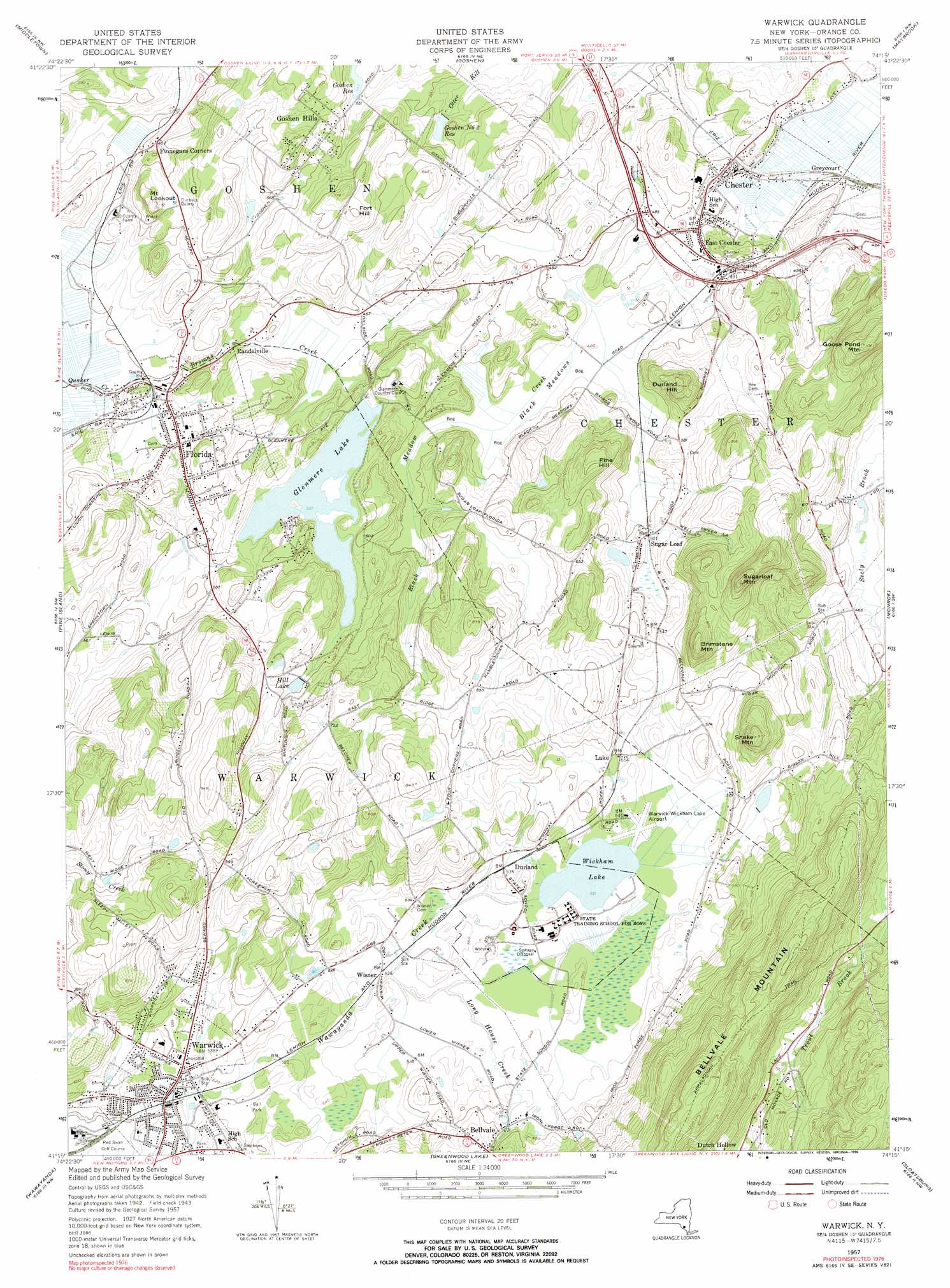
Warwick Topo Map New York
To zoom in, hover over the map of Warwick
USGS Topo Quad 41074c3 - 1:24,000 scale
| Topo Map Name: | Warwick |
| USGS Topo Quad ID: | 41074c3 |
| Print Size: | ca. 21 1/4" wide x 27" high |
| Southeast Coordinates: | 41.25° N latitude / 74.25° W longitude |
| Map Center Coordinates: | 41.3125° N latitude / 74.3125° W longitude |
| U.S. State: | NY |
| Filename: | o41074c3.jpg |
| Download Map JPG Image: | Warwick topo map 1:24,000 scale |
| Map Type: | Topographic |
| Topo Series: | 7.5´ |
| Map Scale: | 1:24,000 |
| Source of Map Images: | United States Geological Survey (USGS) |
| Alternate Map Versions: |
Warwick NY 1943, updated 1954 Download PDF Buy paper map Warwick NY 1957, updated 1958 Download PDF Buy paper map Warwick NY 1957, updated 1966 Download PDF Buy paper map Warwick NY 1957, updated 1990 Download PDF Buy paper map Warwick NY 2010 Download PDF Buy paper map Warwick NY 2013 Download PDF Buy paper map Warwick NY 2016 Download PDF Buy paper map |
1:24,000 Topo Quads surrounding Warwick
Yankee Lake |
Wurtsboro |
Pine Bush |
Walden |
Newburgh |
Otisville |
Middletown |
Goshen |
Maybrook |
Cornwall |
Unionville |
Pine Island |
Warwick |
Monroe |
Popolopen Lake |
Hamburg |
Wawayanda |
Greenwood Lake |
Sloatsburg |
Thiells |
Franklin |
Newfoundland |
Wanaque |
Ramsey |
Park Ridge |
> Back to 41074a1 at 1:100,000 scale
> Back to 41074a1 at 1:250,000 scale
> Back to U.S. Topo Maps home
Warwick topo map: Gazetteer
Warwick: Airports
Orange Poultry Farm Airport elevation 149m 488′Warwick Municipal Airport elevation 161m 528′
Warwick: Flats
Black Meadows elevation 145m 475′Warwick: Lakes
Wickham Lake elevation 159m 521′Warwick: Mines
Duchess Quarry elevation 162m 531′Warwick: Parks
Chester Commons Park elevation 174m 570′Lewis Park elevation 160m 524′
Village Park elevation 140m 459′
Walter R Sturr Memorial Park elevation 129m 423′
Warwick Township Veterans Memorial Park elevation 159m 521′
Warwick: Populated Places
Bellvale elevation 195m 639′Cedarcrest elevation 154m 505′
Chester elevation 146m 479′
Durland elevation 164m 538′
East Chester elevation 151m 495′
Finnegans Corners elevation 133m 436′
Florida elevation 136m 446′
Greycourt elevation 132m 433′
Hempstead Acres elevation 147m 482′
Homestead Village elevation 169m 554′
Randelville elevation 136m 446′
Renee Gardens elevation 146m 479′
Sugar Loaf elevation 155m 508′
Valley View At Chester elevation 172m 564′
Warwick elevation 158m 518′
Wisner elevation 162m 531′
Warwick: Reservoirs
Glenmere Lake elevation 162m 531′Goshen Number Two Reservoir elevation 141m 462′
Hill Lake elevation 180m 590′
Warwick: Streams
Browns Creek elevation 121m 396′Long House Creek elevation 158m 518′
Trout Brook elevation 139m 456′
Warwick: Summits
Brimstone Mountain elevation 284m 931′Durland Hill elevation 256m 839′
Fort Hill elevation 215m 705′
Goose Pond Mountain elevation 325m 1066′
Goshen Hills elevation 194m 636′
Mount Lookout elevation 202m 662′
Pine Hill elevation 253m 830′
Snake Mountain elevation 294m 964′
Sugarloaf Mountain elevation 347m 1138′
Warwick digital topo map on disk
Buy this Warwick topo map showing relief, roads, GPS coordinates and other geographical features, as a high-resolution digital map file on DVD:
New York, Vermont, Connecticut & Western Massachusetts
Buy digital topo maps: New York, Vermont, Connecticut & Western Massachusetts