Pleasantville Topo Map Pennsylvania
To zoom in, hover over the map of Pleasantville
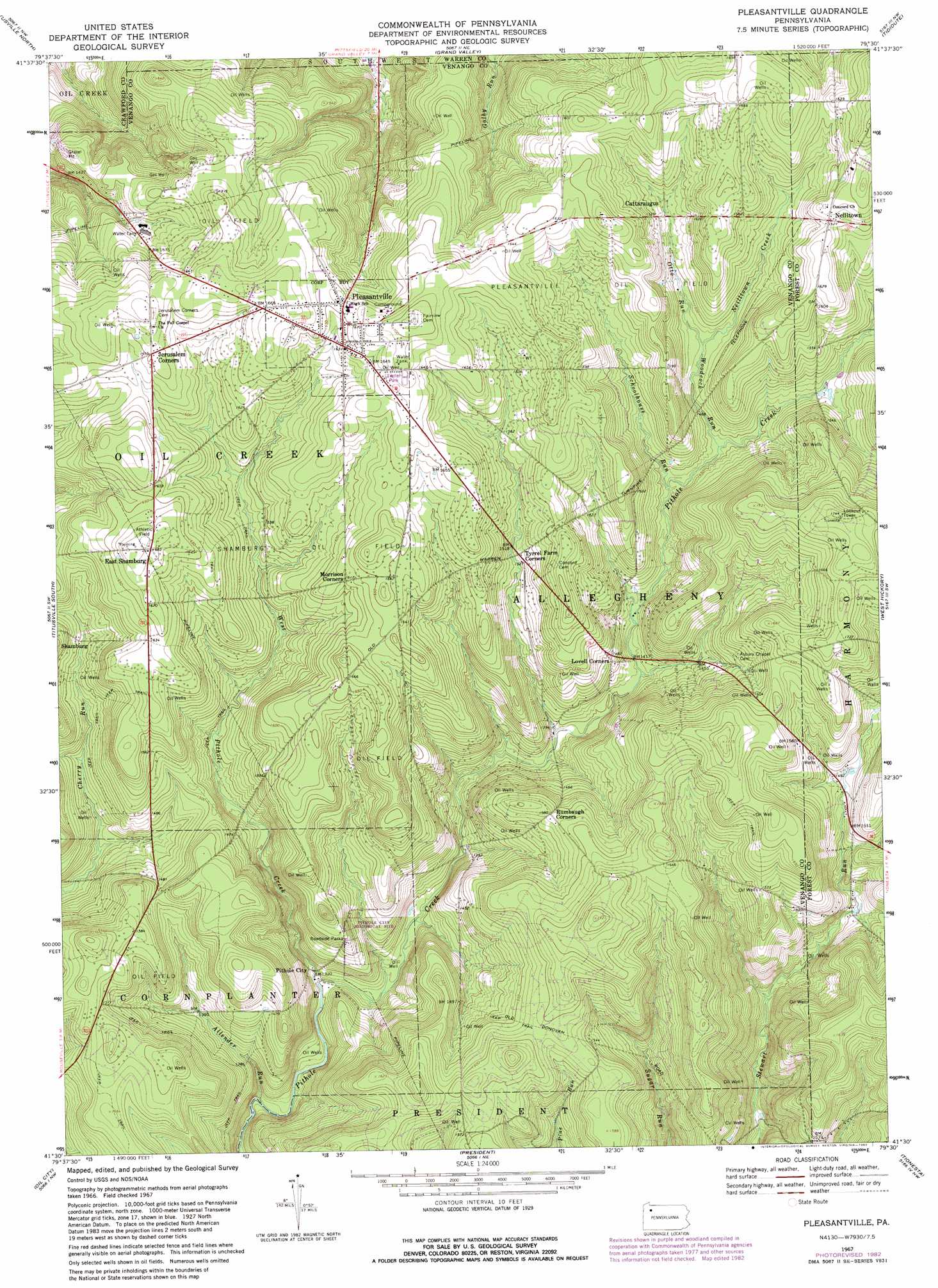
USGS Topo Quad 41079e5 - 1:24,000 scale
| Topo Map Name: | Pleasantville |
| USGS Topo Quad ID: | 41079e5 |
| Print Size: | ca. 21 1/4" wide x 27" high |
| Southeast Coordinates: | 41.5° N latitude / 79.5° W longitude |
| Map Center Coordinates: | 41.5625° N latitude / 79.5625° W longitude |
| U.S. State: | PA |
| Filename: | o41079e5.jpg |
| Download Map JPG Image: | Pleasantville topo map 1:24,000 scale |
| Map Type: | Topographic |
| Topo Series: | 7.5´ |
| Map Scale: | 1:24,000 |
| Source of Map Images: | United States Geological Survey (USGS) |
| Alternate Map Versions: |
Pleasantville PA 1967, updated 1971 Download PDF Buy paper map Pleasantville PA 1967, updated 1973 Download PDF Buy paper map Pleasantville PA 1967, updated 1982 Download PDF Buy paper map Pleasantville PA 2010 Download PDF Buy paper map Pleasantville PA 2013 Download PDF Buy paper map Pleasantville PA 2016 Download PDF Buy paper map |
1:24,000 Topo Quads surrounding Pleasantville
Lake Canadohta |
Spartansburg |
Spring Creek |
Pittsfield |
Youngsville |
Centerville |
Titusville North |
Grand Valley |
Tidioute |
Cobham |
Dempseytown |
Titusville South |
Pleasantville |
West Hickory |
Kellettville |
Franklin |
Oil City |
President |
Tionesta |
Tylersburg |
Kennerdell |
Cranberry |
Kossuth |
Fryburg |
Lucinda |
> Back to 41079e1 at 1:100,000 scale
> Back to 41078a1 at 1:250,000 scale
> Back to U.S. Topo Maps home
Pleasantville topo map: Gazetteer
Pleasantville: Oilfields
Pleasantville Oil Field elevation 469m 1538′Shamburg Oil Field elevation 492m 1614′
Pleasantville: Parks
Pithole City Historical Site elevation 450m 1476′Pleasantville: Populated Places
East Shamburg elevation 514m 1686′Neilltown elevation 494m 1620′
Pithole City elevation 403m 1322′
Pleasantville elevation 503m 1650′
Pleasantville: Streams
Allender Run elevation 386m 1266′Neilltown Creek elevation 451m 1479′
Otto Run elevation 451m 1479′
Schoolhouse Run elevation 437m 1433′
Simonds Run elevation 405m 1328′
West Pithole Creek elevation 396m 1299′
Woodcock Run elevation 439m 1440′
Pleasantville digital topo map on disk
Buy this Pleasantville topo map showing relief, roads, GPS coordinates and other geographical features, as a high-resolution digital map file on DVD:
 map DVD")