Kinyon Topo Map California
To zoom in, hover over the map of Kinyon
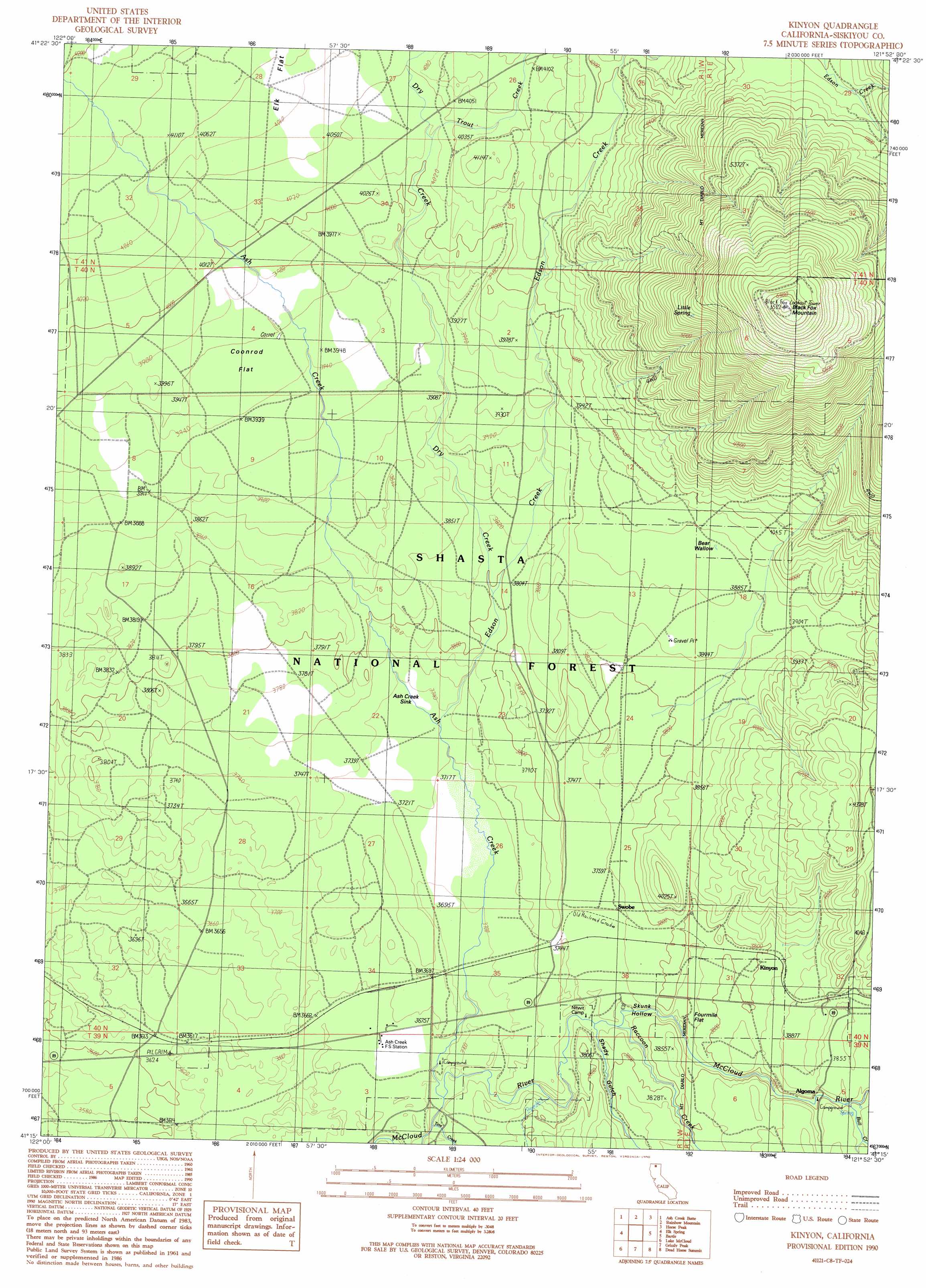
USGS Topo Quad 41121c8 - 1:24,000 scale
| Topo Map Name: | Kinyon |
| USGS Topo Quad ID: | 41121c8 |
| Print Size: | ca. 21 1/4" wide x 27" high |
| Southeast Coordinates: | 41.25° N latitude / 121.875° W longitude |
| Map Center Coordinates: | 41.3125° N latitude / 121.9375° W longitude |
| U.S. State: | CA |
| Filename: | o41121c8.jpg |
| Download Map JPG Image: | Kinyon topo map 1:24,000 scale |
| Map Type: | Topographic |
| Topo Series: | 7.5´ |
| Map Scale: | 1:24,000 |
| Source of Map Images: | United States Geological Survey (USGS) |
| Alternate Map Versions: |
Kinyon CA 1990, updated 1990 Download PDF Buy paper map Kinyon CA 1998, updated 2003 Download PDF Buy paper map Kinyon CA 1998, updated 2003 Download PDF Buy paper map Kinyon CA 2012 Download PDF Buy paper map Kinyon CA 2015 Download PDF Buy paper map |
| FStopo: | US Forest Service topo Kinyon is available: Download FStopo PDF Download FStopo TIF |
1:24,000 Topo Quads surrounding Kinyon
The Whaleback |
West Haight Mountain |
Tennant |
Garner Mountain |
Little Glass Mountain |
Mount Shasta |
Ash Creek Butte |
Rainbow Mountain |
Horse Peak |
Snag Hill |
Mccloud |
Elk Spring |
Kinyon |
Bartle |
Hambone |
Girard Ridge |
Lake Mccloud |
Grizzly Peak |
Dead Horse Summit |
Pondosa |
Yellowjacket Mountain |
Shoeinhorse Mountain |
Big Bend |
Skunk Ridge |
Burney Falls |
> Back to 41121a1 at 1:100,000 scale
> Back to 41120a1 at 1:250,000 scale
> Back to U.S. Topo Maps home
Kinyon topo map: Gazetteer
Kinyon: Basins
Ash Creek Sink elevation 1140m 3740′Bear Wallow elevation 1193m 3914′
Skunk Hollow elevation 1160m 3805′
Kinyon: Flats
Coonrod Flat elevation 1208m 3963′Elk Flat elevation 1248m 4094′
Fourmile Flat elevation 1139m 3736′
Kinyon: Populated Places
Ash Creek Station (historical) elevation 1128m 3700′Kinyon elevation 1159m 3802′
Swobe elevation 1145m 3756′
Kinyon: Springs
Little Spring elevation 1653m 5423′Kinyon: Streams
Ash Creek elevation 1112m 3648′Bull Creek elevation 1159m 3802′
Dry Creek elevation 1158m 3799′
Edson Creek elevation 1136m 3727′
Raccoon Creek elevation 1132m 3713′
Tate Creek elevation 1111m 3645′
Trout Creek elevation 1226m 4022′
Kinyon: Summits
Black Fox Mountain elevation 1976m 6482′Kinyon: Valleys
Shady Gulch elevation 1143m 3750′Kinyon digital topo map on disk
Buy this Kinyon topo map showing relief, roads, GPS coordinates and other geographical features, as a high-resolution digital map file on DVD: