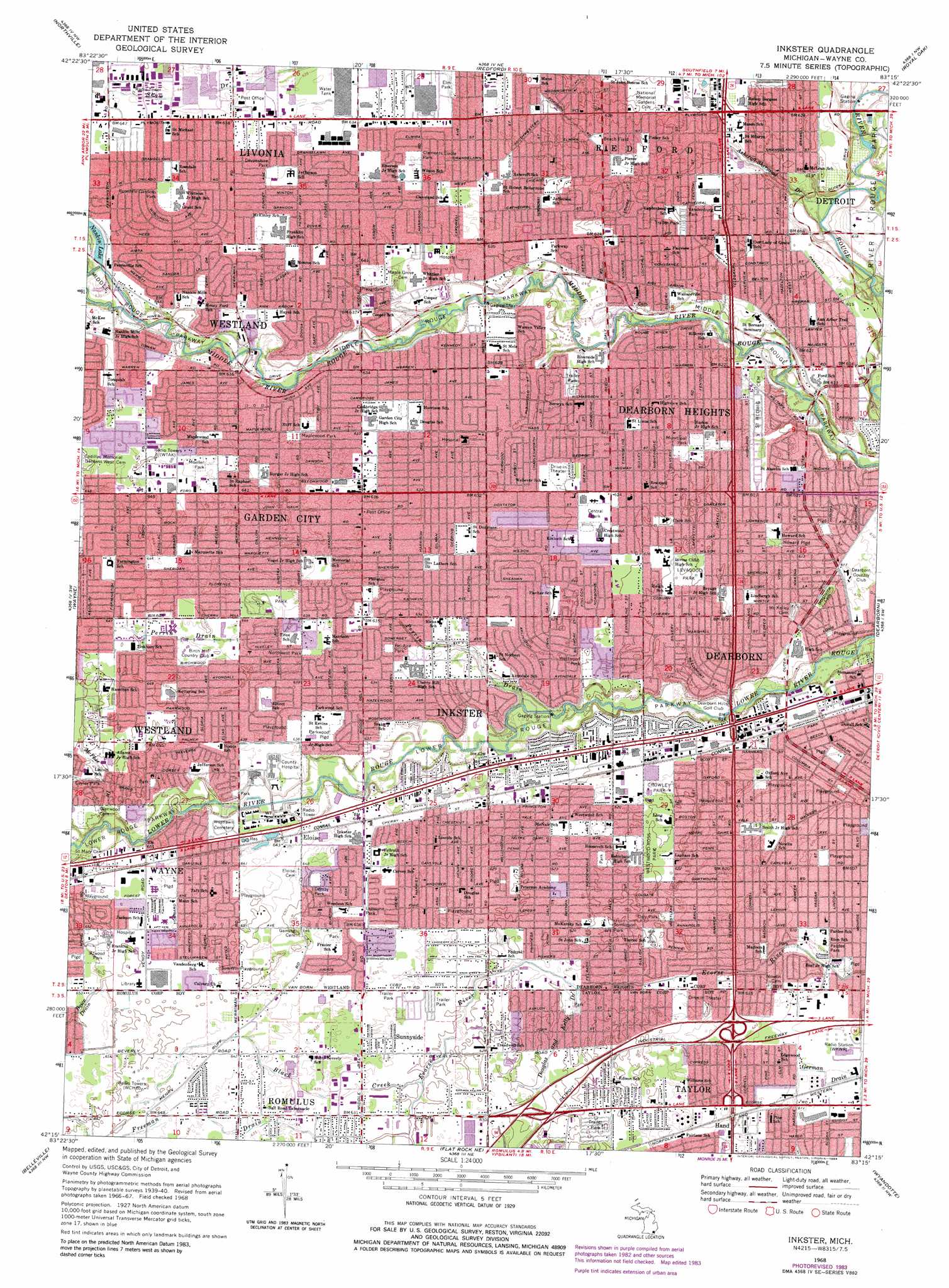
Inkster Topo Map Michigan
To zoom in, hover over the map of Inkster
USGS Topo Quad 42083c3 - 1:24,000 scale
| Topo Map Name: | Inkster |
| USGS Topo Quad ID: | 42083c3 |
| Print Size: | ca. 21 1/4" wide x 27" high |
| Southeast Coordinates: | 42.25° N latitude / 83.25° W longitude |
| Map Center Coordinates: | 42.3125° N latitude / 83.3125° W longitude |
| U.S. State: | MI |
| Filename: | o42083c3.jpg |
| Download Map JPG Image: | Inkster topo map 1:24,000 scale |
| Map Type: | Topographic |
| Topo Series: | 7.5´ |
| Map Scale: | 1:24,000 |
| Source of Map Images: | United States Geological Survey (USGS) |
| Alternate Map Versions: |
Inkster MI 1942 Download PDF Buy paper map Inkster MI 1952, updated 1954 Download PDF Buy paper map Inkster MI 1968, updated 1970 Download PDF Buy paper map Inkster MI 1968, updated 1974 Download PDF Buy paper map Inkster MI 1968, updated 1984 Download PDF Buy paper map Inkster MI 1996, updated 2000 Download PDF Buy paper map Inkster MI 2011 Download PDF Buy paper map Inkster MI 2014 Download PDF Buy paper map Inkster MI 2017 Download PDF Buy paper map |
1:24,000 Topo Quads surrounding Inkster
Milford |
Walled Lake |
Pontiac South |
Birmingham |
Warren |
Salem |
Northville |
Redford |
Royal Oak |
Highland Park |
Denton |
Wayne |
Inkster |
Dearborn |
Detroit |
Ypsilanti East |
Belleville |
Flat Rock Ne |
Wyandotte |
|
Maybee |
Carleton |
Flat Rock |
Rockwood |
> Back to 42083a1 at 1:100,000 scale
> Back to 42082a1 at 1:250,000 scale
> Back to U.S. Topo Maps home
Inkster topo map: Gazetteer
Inkster: Parks
Atwood Park elevation 198m 649′Beach Field elevation 190m 623′
Bel-Aire Park elevation 192m 629′
Cayley Park elevation 198m 649′
Central Park elevation 190m 623′
Clements Circle Park elevation 192m 629′
Crowley Park elevation 190m 623′
Daly Park elevation 190m 623′
Demby Park elevation 197m 646′
Devonshire Park elevation 193m 633′
Elm Park elevation 192m 629′
Howard Playground elevation 189m 620′
Lemoyne Park elevation 194m 636′
Levagood Park elevation 190m 623′
Lower Rouge Parkway elevation 183m 600′
Maplewood Park elevation 193m 633′
Middle Rouge Parkway elevation 186m 610′
Moeller Park elevation 195m 639′
Northwest Park elevation 195m 639′
Pardee Park elevation 185m 606′
Parkwood Playground elevation 194m 636′
Rosedale Gardens Park elevation 196m 643′
Sue-Win Playground elevation 198m 649′
Tomlinson Park elevation 191m 626′
Vandenburg Park elevation 190m 623′
Westwood Park elevation 190m 623′
Westwood-Ross Park elevation 190m 623′
Inkster: Populated Places
Dearborn Heights elevation 189m 620′Eloise elevation 195m 639′
Garden City elevation 193m 633′
Hand elevation 189m 620′
Inkster elevation 191m 626′
Livonia elevation 195m 639′
Sunnyside elevation 192m 629′
Inkster: Post Offices
Dearborn Heights Post Office elevation 190m 623′Dearborn Post Office elevation 185m 606′
Inkster Post Office elevation 188m 616′
Inkster: Reservoirs
Nankin Lake elevation 194m 636′Inkster: Streams
Ashcroft-Sherwood Drain elevation 178m 583′Black Creek elevation 189m 620′
Boice Drain elevation 198m 649′
Douglas and Kelly Drain elevation 187m 613′
Godfrey Drain elevation 190m 623′
McPhee Drain elevation 190m 623′
Perrin Drain elevation 183m 600′
Tonquish Creek elevation 189m 620′
Inkster digital topo map on disk
Buy this Inkster topo map showing relief, roads, GPS coordinates and other geographical features, as a high-resolution digital map file on DVD:
 map DVD")