Waukegan Topo Map Illinois
To zoom in, hover over the map of Waukegan
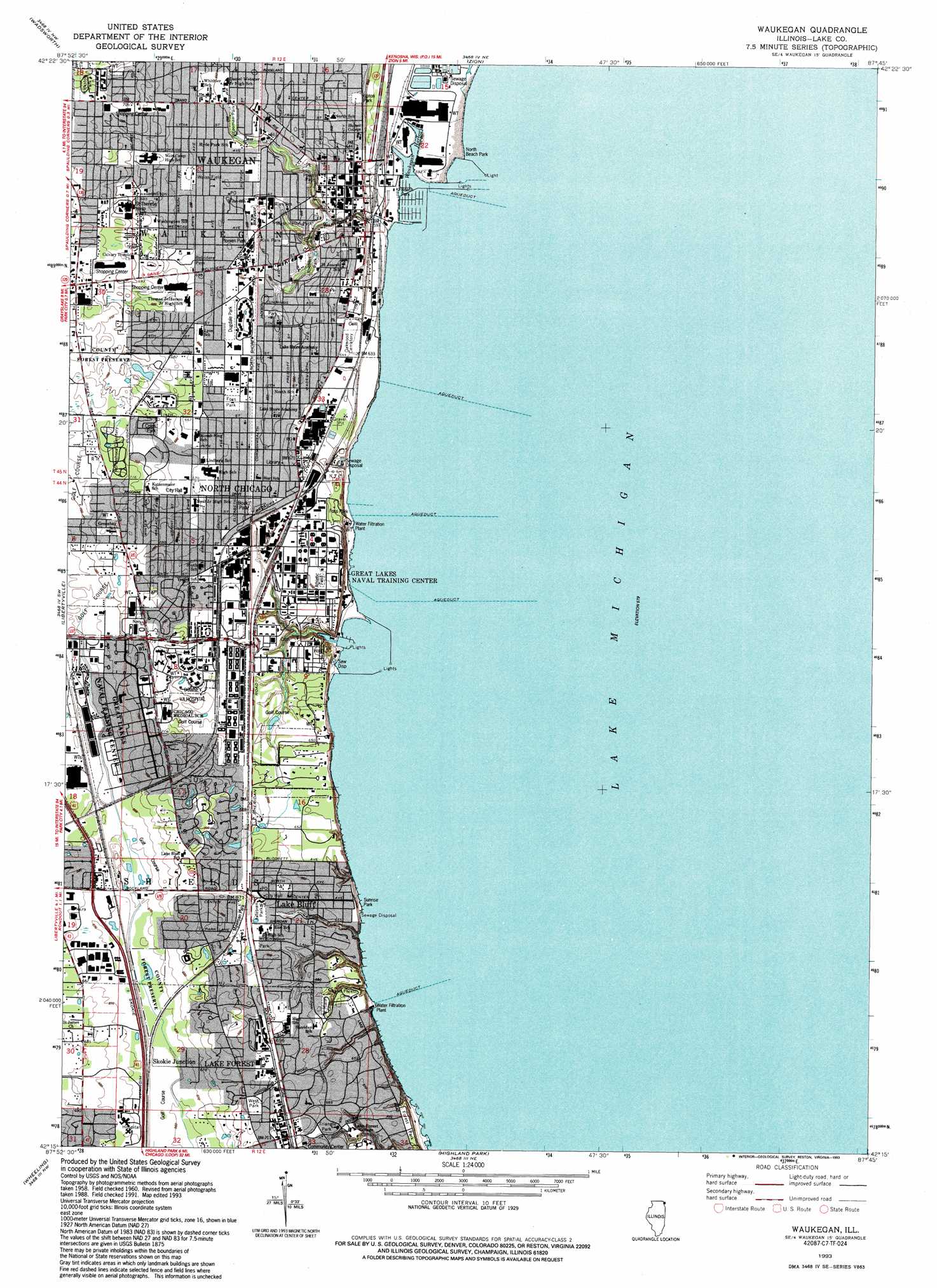
USGS Topo Quad 42087c7 - 1:24,000 scale
| Topo Map Name: | Waukegan |
| USGS Topo Quad ID: | 42087c7 |
| Print Size: | ca. 21 1/4" wide x 27" high |
| Southeast Coordinates: | 42.25° N latitude / 87.75° W longitude |
| Map Center Coordinates: | 42.3125° N latitude / 87.8125° W longitude |
| U.S. State: | IL |
| Filename: | o42087c7.jpg |
| Download Map JPG Image: | Waukegan topo map 1:24,000 scale |
| Map Type: | Topographic |
| Topo Series: | 7.5´ |
| Map Scale: | 1:24,000 |
| Source of Map Images: | United States Geological Survey (USGS) |
| Alternate Map Versions: |
Weukegan IL 1960, updated 1962 Download PDF Buy paper map Weukegan IL 1960, updated 1973 Download PDF Buy paper map Weukegan IL 1960, updated 1981 Download PDF Buy paper map Waukegan IL 1960, updated 1988 Download PDF Buy paper map Waukegan IL 1993, updated 1993 Download PDF Buy paper map Waukegan IL 1998, updated 2003 Download PDF Buy paper map Waukegan IL 2012 Download PDF Buy paper map Waukegan IL 2015 Download PDF Buy paper map |
1:24,000 Topo Quads surrounding Waukegan
Paddock Lake |
Pleasant Prairie |
Kenosha |
||
Antioch |
Wadsworth |
Zion |
||
Grayslake |
Libertyville |
Waukegan |
||
Lake Zurich |
Wheeling |
Highland Park |
||
Palatine |
Arlington Heights |
Park Ridge |
Evanston |
> Back to 42087a1 at 1:100,000 scale
> Back to 42086a1 at 1:250,000 scale
> Back to U.S. Topo Maps home
Waukegan topo map: Gazetteer
Waukegan: Airports
Lake Forest Hospital Heliport elevation 204m 669′Saint Therese Medical Center Heliport elevation 213m 698′
Waukegan: Bays
Waukegan Harbor elevation 177m 580′Waukegan: Parks
Artesian Park elevation 207m 679′Beach Park elevation 179m 587′
Bedrosian Park elevation 199m 652′
Belvidere Park elevation 201m 659′
Blair Park elevation 215m 705′
Boak Park elevation 199m 652′
Coles Park elevation 210m 688′
Constitution Park elevation 199m 652′
Dugdale Park elevation 199m 652′
Forest Park elevation 203m 666′
Foss Park elevation 200m 656′
Foss Park elevation 197m 646′
Grand Avenue Park elevation 189m 620′
Hinkston Park elevation 216m 708′
Howard Ganster Pool elevation 202m 662′
Kirk Park elevation 198m 649′
Kocal Field elevation 201m 659′
Mawman Park elevation 210m 688′
North Beach Park elevation 180m 590′
Plonien Park elevation 198m 649′
Powell Park elevation 189m 620′
Ravine Park elevation 200m 656′
Roosevelt Park elevation 184m 603′
Skokie River Nature Preserve elevation 204m 669′
Sunrise Park elevation 175m 574′
Triangle Park elevation 205m 672′
Upton Park elevation 193m 633′
Washington Park elevation 184m 603′
Weiss Field elevation 201m 659′
West Park elevation 217m 711′
Yeoman Park elevation 198m 649′
Waukegan: Populated Places
Five Points elevation 219m 718′Great Lakes elevation 201m 659′
Lake Bluff elevation 201m 659′
Lake Forest elevation 210m 688′
North Chicago elevation 201m 659′
Skokie Junction elevation 207m 679′
Waukegan elevation 199m 652′
Waukegan: Post Offices
Edison Square Station Waukegan Post Office elevation 200m 656′Lake Bluff Post Office elevation 207m 679′
Lake Bluff Post Office (historical) elevation 201m 659′
Lake Forest Post Office elevation 216m 708′
North Chicago Post Office elevation 202m 662′
Waukegan Post Office elevation 197m 646′
Waukegan: Streams
Pettibone Creek elevation 175m 574′Sunderland Creek elevation 177m 580′
Waukegan River elevation 175m 574′
Waukegan digital topo map on disk
Buy this Waukegan topo map showing relief, roads, GPS coordinates and other geographical features, as a high-resolution digital map file on DVD:
Northern Illinois, Northern Indiana & Southwestern Michigan
Buy digital topo maps: Northern Illinois, Northern Indiana & Southwestern Michigan