Anderson Ridge Topo Map Wyoming
To zoom in, hover over the map of Anderson Ridge
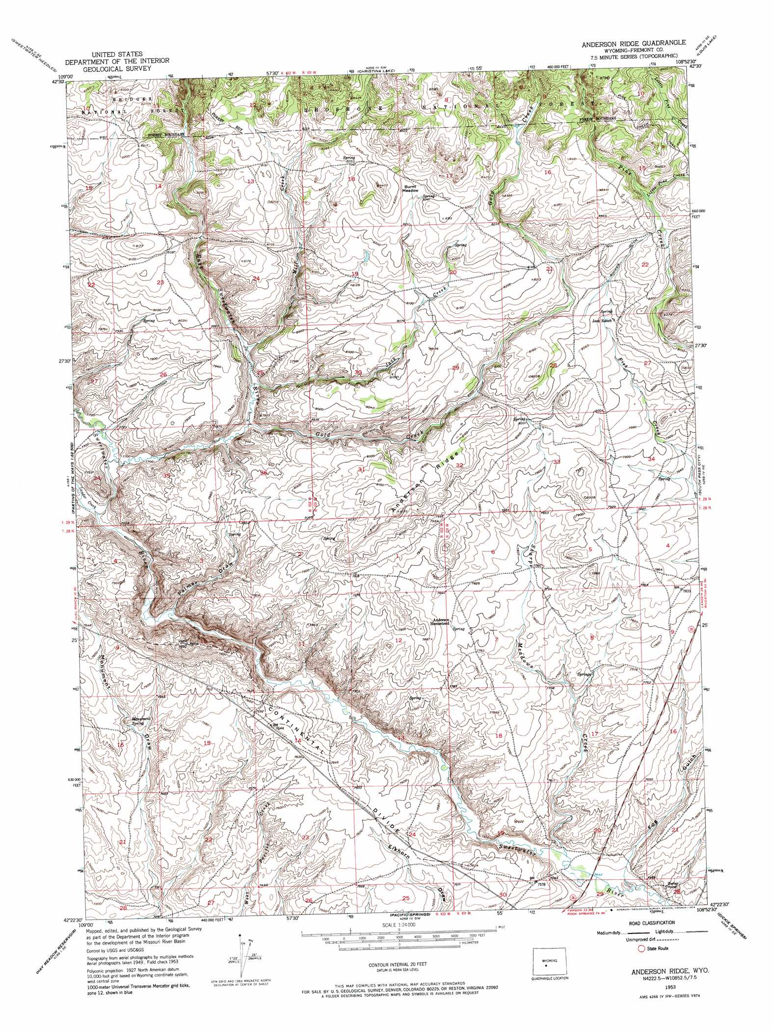
USGS Topo Quad 42108d8 - 1:24,000 scale
| Topo Map Name: | Anderson Ridge |
| USGS Topo Quad ID: | 42108d8 |
| Print Size: | ca. 21 1/4" wide x 27" high |
| Southeast Coordinates: | 42.375° N latitude / 108.875° W longitude |
| Map Center Coordinates: | 42.4375° N latitude / 108.9375° W longitude |
| U.S. State: | WY |
| Filename: | o42108d8.jpg |
| Download Map JPG Image: | Anderson Ridge topo map 1:24,000 scale |
| Map Type: | Topographic |
| Topo Series: | 7.5´ |
| Map Scale: | 1:24,000 |
| Source of Map Images: | United States Geological Survey (USGS) |
| Alternate Map Versions: |
Anderson Ridge WY 1991, updated 1997 Download PDF Buy paper map Anderson Ridge WY 2012 Download PDF Buy paper map Anderson Ridge WY 2015 Download PDF Buy paper map |
| FStopo: | US Forest Service topo Anderson Ridge is available: Download FStopo PDF Download FStopo TIF |
1:24,000 Topo Quads surrounding Anderson Ridge
Temple Peak |
Sweetwater Gap |
Cony Mountain |
Fossil Hill |
Wolf Point |
Jensen Meadows |
Sweetwater Needles |
Christina Lake |
Louis Lake |
Miners Delight |
Prospect Mountains |
Halls Meadow Spring |
Anderson Ridge |
South Pass City |
Atlantic City |
Parting Of The Ways |
Hay Meadow Reservoir |
Pacific Springs |
Dickie Springs |
Continental Peak |
Tule Butte |
North Packsaddle Canyon |
Rock Cabin Spring |
Joe Hay Rim |
Bob Jack Well |
> Back to 42108a1 at 1:100,000 scale
> Back to 42108a1 at 1:250,000 scale
> Back to U.S. Topo Maps home
Anderson Ridge topo map: Gazetteer
Anderson Ridge: Canals
Rinker Ditch elevation 2501m 8205′Anderson Ridge: Flats
Burnt Meadow elevation 2523m 8277′Anderson Ridge: Ridges
Anderson Ridge elevation 2489m 8166′Anderson Ridge: Springs
Monument Spring elevation 2275m 7463′Anderson Ridge: Streams
East Sweetwater River elevation 2344m 7690′Gold Creek elevation 2362m 7749′
Jack Creek elevation 2366m 7762′
Lander Creek elevation 2324m 7624′
Little Pine Creek elevation 2514m 8248′
Mill Creek elevation 2372m 7782′
Sharps Meadows Creek elevation 2272m 7454′
Anderson Ridge: Valleys
Fog Gulch elevation 2277m 7470′Palmer Draw elevation 2308m 7572′
Anderson Ridge digital topo map on disk
Buy this Anderson Ridge topo map showing relief, roads, GPS coordinates and other geographical features, as a high-resolution digital map file on DVD: