Connor Ridge Topo Map Idaho
To zoom in, hover over the map of Connor Ridge
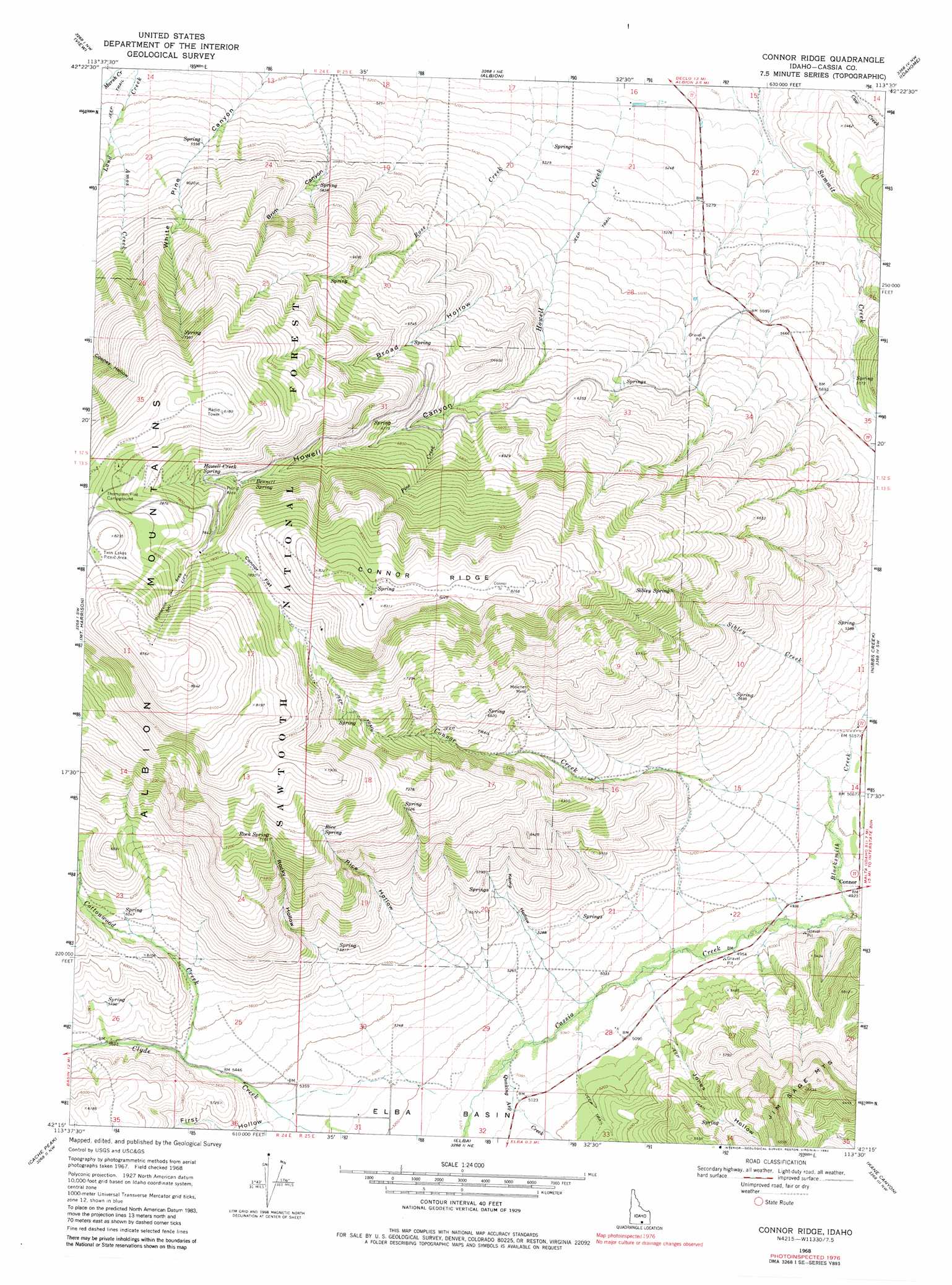
USGS Topo Quad 42113c5 - 1:24,000 scale
| Topo Map Name: | Connor Ridge |
| USGS Topo Quad ID: | 42113c5 |
| Print Size: | ca. 21 1/4" wide x 27" high |
| Southeast Coordinates: | 42.25° N latitude / 113.5° W longitude |
| Map Center Coordinates: | 42.3125° N latitude / 113.5625° W longitude |
| U.S. State: | ID |
| Filename: | o42113c5.jpg |
| Download Map JPG Image: | Connor Ridge topo map 1:24,000 scale |
| Map Type: | Topographic |
| Topo Series: | 7.5´ |
| Map Scale: | 1:24,000 |
| Source of Map Images: | United States Geological Survey (USGS) |
| Alternate Map Versions: |
Connor Ridge ID 1968, updated 1972 Download PDF Buy paper map Connor Ridge ID 1968, updated 1982 Download PDF Buy paper map Connor Ridge ID 2001, updated 2006 Download PDF Buy paper map Connor Ridge ID 2011 Download PDF Buy paper map Connor Ridge ID 2013 Download PDF Buy paper map |
| FStopo: | US Forest Service topo Connor Ridge is available: Download FStopo PDF Download FStopo TIF |
1:24,000 Topo Quads surrounding Connor Ridge
Burley |
Rupert |
Rupert Se |
Lake Walcott Sw |
Lake Walcott Se |
Kenyon |
View |
Albion |
Idahome |
Malta Ne |
Marion Se |
Mount Harrison |
Connor Ridge |
Nibbs Creek |
Malta |
Basin |
Cache Peak |
Elba |
Kane Canyon |
Bridge |
Lyman Pass |
Almo |
Jim Sage Canyon |
Chokecherry Canyon |
Naf |
> Back to 42113a1 at 1:100,000 scale
> Back to 42112a1 at 1:250,000 scale
> Back to U.S. Topo Maps home
Connor Ridge topo map: Gazetteer
Connor Ridge: Basins
Elba Basin elevation 1554m 5098′Connor Ridge: Flats
Connor Flat elevation 2396m 7860′Connor Ridge: Populated Places
Connor elevation 1503m 4931′Connor Ridge: Ridges
Connor Ridge elevation 2507m 8225′Connor Ridge: Springs
Bennett Spring elevation 2244m 7362′Howell Creek Spring elevation 2291m 7516′
Rice Spring elevation 2172m 7125′
Rock Spring elevation 2188m 7178′
Sibley Spring elevation 2140m 7020′
Connor Ridge: Streams
Amos Creek elevation 1677m 5501′Blacksmith Creek elevation 1487m 4878′
Connor Creek elevation 1488m 4881′
Cottonwood Creek elevation 1682m 5518′
Pine Creek elevation 1966m 6450′
Quaking Asp Creek elevation 1544m 5065′
Rose Creek elevation 1558m 5111′
Sibley Creek elevation 1588m 5209′
Connor Ridge: Valleys
Brim Canyon elevation 1717m 5633′Broad Hollow elevation 1824m 5984′
First Hollow elevation 1637m 5370′
Howell Canyon elevation 1820m 5971′
Jones Hollow elevation 1544m 5065′
Kemp Hollow elevation 1585m 5200′
Rice Hollow elevation 1769m 5803′
Rocky Hollow elevation 1738m 5702′
Connor Ridge digital topo map on disk
Buy this Connor Ridge topo map showing relief, roads, GPS coordinates and other geographical features, as a high-resolution digital map file on DVD: