Blackstone Reservoir Topo Map Idaho
To zoom in, hover over the map of Blackstone Reservoir
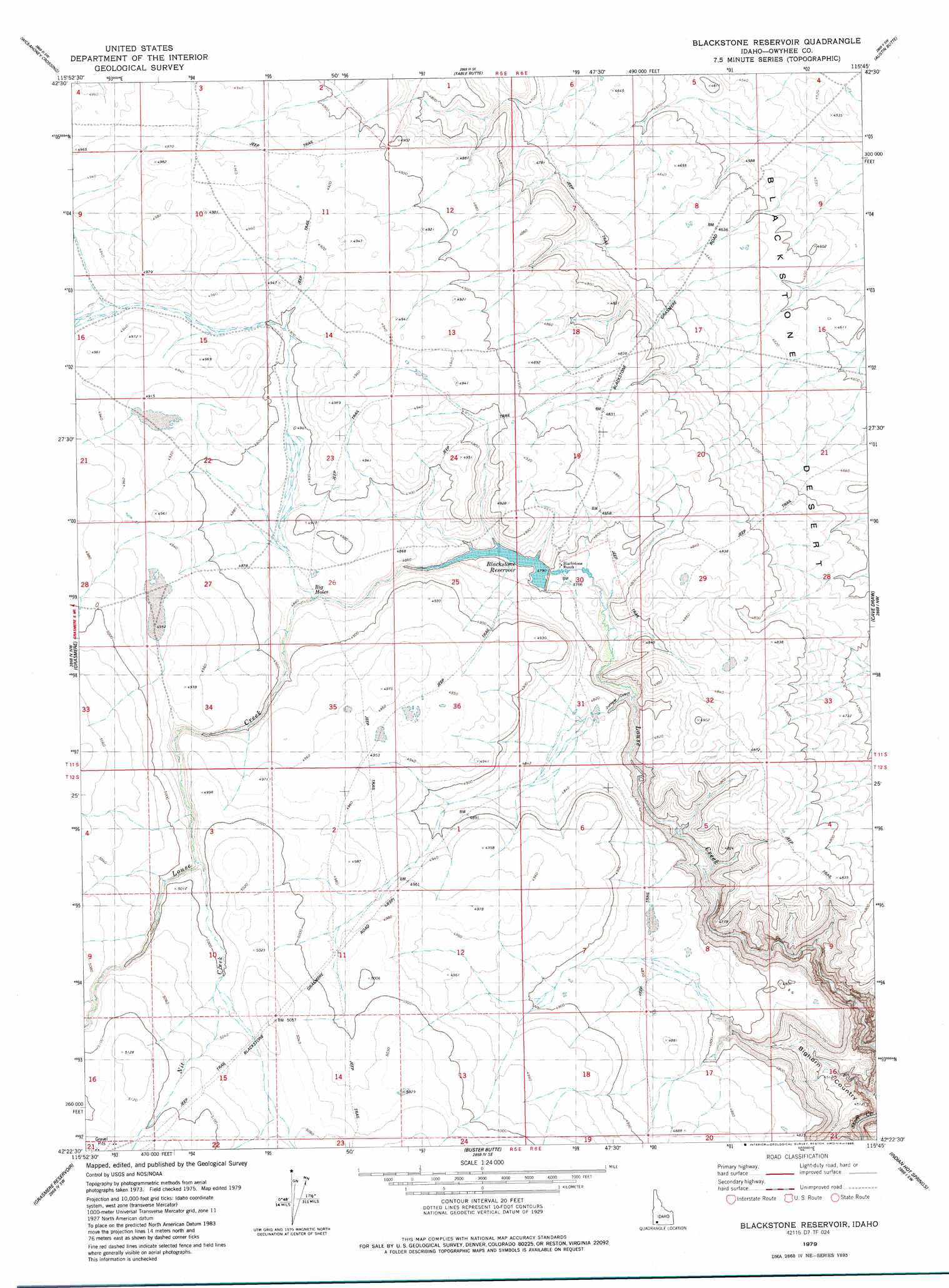
USGS Topo Quad 42115d7 - 1:24,000 scale
| Topo Map Name: | Blackstone Reservoir |
| USGS Topo Quad ID: | 42115d7 |
| Print Size: | ca. 21 1/4" wide x 27" high |
| Southeast Coordinates: | 42.375° N latitude / 115.75° W longitude |
| Map Center Coordinates: | 42.4375° N latitude / 115.8125° W longitude |
| U.S. State: | ID |
| Filename: | o42115d7.jpg |
| Download Map JPG Image: | Blackstone Reservoir topo map 1:24,000 scale |
| Map Type: | Topographic |
| Topo Series: | 7.5´ |
| Map Scale: | 1:24,000 |
| Source of Map Images: | United States Geological Survey (USGS) |
| Alternate Map Versions: |
Blackstone Reservoir ID 1979, updated 1979 Download PDF Buy paper map Blackstone Reservoir ID 1979, updated 1986 Download PDF Buy paper map Blackstone Reservoir ID 2010 Download PDF Buy paper map Blackstone Reservoir ID 2013 Download PDF Buy paper map |
1:24,000 Topo Quads surrounding Blackstone Reservoir
Big Horse Basin Gap |
Hole In Rock |
Broken Wagon Flat |
Crowbar Gulch |
Pot Hole Butte |
Hill Pasture |
Wickahoney Crossing |
Table Butte |
Austin Butte |
Winter Camp |
Wickahoney Point |
Grasmere |
Blackstone Reservoir |
Cave Draw |
Stiff Tree Draw |
Little Blue Table |
Grasmere Reservoir |
Buster Butte |
Indian Hot Springs |
Inside Lakes |
Riddle |
Buckhorn |
Antelope Creek |
Triguero Lake |
The Arch |
> Back to 42115a1 at 1:100,000 scale
> Back to 42114a1 at 1:250,000 scale
> Back to U.S. Topo Maps home
Blackstone Reservoir topo map: Gazetteer
Blackstone Reservoir: Bends
Big Holes elevation 1478m 4849′Blackstone Reservoir: Dams
Strickland Dam elevation 1460m 4790′Blackstone Reservoir: Reservoirs
Blackstone Reservoir elevation 1460m 4790′Blackstone Reservoir: Streams
Nit Creek elevation 1513m 4963′Blackstone Reservoir: Valleys
Juniper Draw elevation 1463m 4799′Blackstone Reservoir digital topo map on disk
Buy this Blackstone Reservoir topo map showing relief, roads, GPS coordinates and other geographical features, as a high-resolution digital map file on DVD: