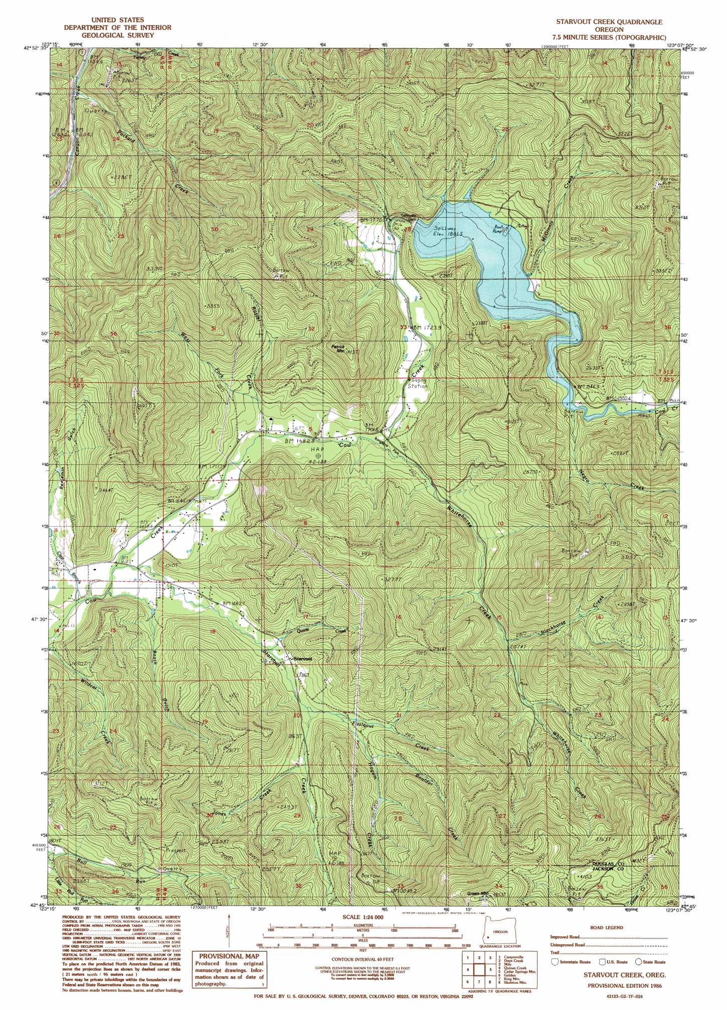
Starvout Creek Topo Map Oregon
To zoom in, hover over the map of Starvout Creek
USGS Topo Quad 42123g2 - 1:24,000 scale
| Topo Map Name: | Starvout Creek |
| USGS Topo Quad ID: | 42123g2 |
| Print Size: | ca. 21 1/4" wide x 27" high |
| Southeast Coordinates: | 42.75° N latitude / 123.125° W longitude |
| Map Center Coordinates: | 42.8125° N latitude / 123.1875° W longitude |
| U.S. State: | OR |
| Filename: | o42123g2.jpg |
| Download Map JPG Image: | Starvout Creek topo map 1:24,000 scale |
| Map Type: | Topographic |
| Topo Series: | 7.5´ |
| Map Scale: | 1:24,000 |
| Source of Map Images: | United States Geological Survey (USGS) |
| Alternate Map Versions: |
Starvout Creek OR 1986, updated 1987 Download PDF Buy paper map Starvout Creek OR 2011 Download PDF Buy paper map Starvout Creek OR 2014 Download PDF Buy paper map |
1:24,000 Topo Quads surrounding Starvout Creek
Winston |
Myrtle Creek |
Dodson Butte |
White Rock |
Deadman Mountain |
Nickel Mountain |
Canyonville |
Days Creek |
Milo |
Tiller |
Mccullough Creek |
Quines Creek |
Starvout Creek |
Cedar Springs Mountain |
Richter Mountain |
Glendale |
Golden |
King Mountain |
Skeleton Mountain |
Cleveland Ridge |
Merlin |
Sexton Mountain |
Wimer |
Mcconville Peak |
Boswell Mountain |
> Back to 42123e1 at 1:100,000 scale
> Back to 42122a1 at 1:250,000 scale
> Back to U.S. Topo Maps home
Starvout Creek topo map: Gazetteer
Starvout Creek: Airports
Starvout Creek Airport elevation 501m 1643′Starvout Creek: Dams
Galesville Dam elevation 538m 1765′Starvout Creek: Parks
Long Fibre County Park elevation 515m 1689′Starvout Creek: Populated Places
Anchor (historical) elevation 565m 1853′Booth (historical) elevation 496m 1627′
Starvout Creek: Post Offices
Anchor Post Office (historical) elevation 565m 1853′Booth Post Office (historical) elevation 496m 1627′
Starvout Post Office (historical) elevation 581m 1906′
Starvout Creek: Streams
Albro Creek elevation 678m 2224′Alice Creek elevation 576m 1889′
Boulder Creek elevation 611m 2004′
Clear Creek elevation 482m 1581′
Dark Creek elevation 543m 1781′
East Fork Whitehorse Creek elevation 638m 2093′
Fizzleout Creek elevation 554m 1817′
Hogum Creek elevation 569m 1866′
Jones Creek elevation 931m 3054′
McGinnis Creek elevation 565m 1853′
Negro Creek elevation 571m 1873′
Niday Branch Cow Creek elevation 478m 1568′
No Name Creek elevation 606m 1988′
Packard Creek elevation 375m 1230′
Quartz Creek elevation 535m 1755′
Ramsey Creek elevation 619m 2030′
Russel Creek elevation 512m 1679′
Starvout Creek elevation 483m 1584′
West Fork Russel Creek elevation 512m 1679′
Whitehorse Creek elevation 512m 1679′
Starvout Creek: Summits
Green Mountain elevation 1478m 4849′Patrick Mountain elevation 926m 3038′
Starvout Creek: Valleys
Benjamin Gulch elevation 511m 1676′Booth Gulch elevation 506m 1660′
Starvout Creek digital topo map on disk
Buy this Starvout Creek topo map showing relief, roads, GPS coordinates and other geographical features, as a high-resolution digital map file on DVD: