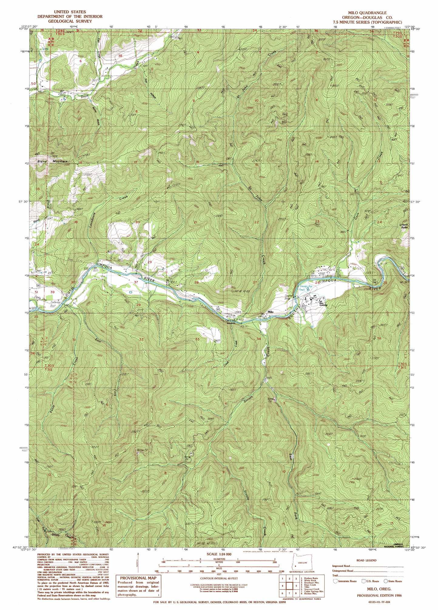
Milo Topo Map Oregon
To zoom in, hover over the map of Milo
USGS Topo Quad 42123h1 - 1:24,000 scale
| Topo Map Name: | Milo |
| USGS Topo Quad ID: | 42123h1 |
| Print Size: | ca. 21 1/4" wide x 27" high |
| Southeast Coordinates: | 42.875° N latitude / 123° W longitude |
| Map Center Coordinates: | 42.9375° N latitude / 123.0625° W longitude |
| U.S. State: | OR |
| Filename: | o42123h1.jpg |
| Download Map JPG Image: | Milo topo map 1:24,000 scale |
| Map Type: | Topographic |
| Topo Series: | 7.5´ |
| Map Scale: | 1:24,000 |
| Source of Map Images: | United States Geological Survey (USGS) |
| Alternate Map Versions: |
Milo OR 1986, updated 1986 Download PDF Buy paper map Milo OR 1998, updated 2000 Download PDF Buy paper map Milo OR 2011 Download PDF Buy paper map Milo OR 2014 Download PDF Buy paper map |
| FStopo: | US Forest Service topo Milo is available: Download FStopo PDF Download FStopo TIF |
1:24,000 Topo Quads surrounding Milo
Roseburg East |
Dixonville |
Lane Mountain |
Red Butte |
Taft Mountain |
Myrtle Creek |
Dodson Butte |
White Rock |
Deadman Mountain |
Dumont Creek |
Canyonville |
Days Creek |
Milo |
Tiller |
Pickett Butte |
Quines Creek |
Starvout Creek |
Cedar Springs Mountain |
Richter Mountain |
Ragsdale Butte |
Golden |
King Mountain |
Skeleton Mountain |
Cleveland Ridge |
Trail |
> Back to 42123e1 at 1:100,000 scale
> Back to 42122a1 at 1:250,000 scale
> Back to U.S. Topo Maps home
Milo topo map: Gazetteer
Milo: Airports
Riverview Ranch Airport elevation 260m 853′Milo: Mines
Miller Mine elevation 615m 2017′Milo: Parks
Hill County Wayside elevation 274m 898′Milo: Populated Places
Lavadoure (historical) elevation 270m 885′Milo elevation 278m 912′
Perdue (historical) elevation 281m 921′
Milo: Post Offices
Milo Post Office (historical) elevation 278m 912′Perdue Post Office (historical) elevation 271m 889′
Milo: Streams
Ash Creek elevation 274m 898′Canyon Creek elevation 316m 1036′
Cedar Creek elevation 281m 921′
Coble Creek elevation 321m 1053′
Coffee Creek elevation 292m 958′
Coon Creek elevation 272m 892′
Corn Creek elevation 281m 921′
East Fork Poole Creek elevation 271m 889′
East Fork Stouts Creek elevation 306m 1003′
Fate Creek elevation 289m 948′
Gilbeaugh Creek elevation 284m 931′
Lavadoure Creek elevation 261m 856′
Lick Creek elevation 284m 931′
Perdue Creek elevation 273m 895′
Poole Creek elevation 260m 853′
Saint John Creek elevation 271m 889′
Stouts Creek elevation 275m 902′
Milo: Summits
Bland Mountain elevation 799m 2621′O'Neill Butte elevation 692m 2270′
Milo: Valleys
Bailey Gulch elevation 295m 967′Doe Hollow elevation 316m 1036′
Milo digital topo map on disk
Buy this Milo topo map showing relief, roads, GPS coordinates and other geographical features, as a high-resolution digital map file on DVD: