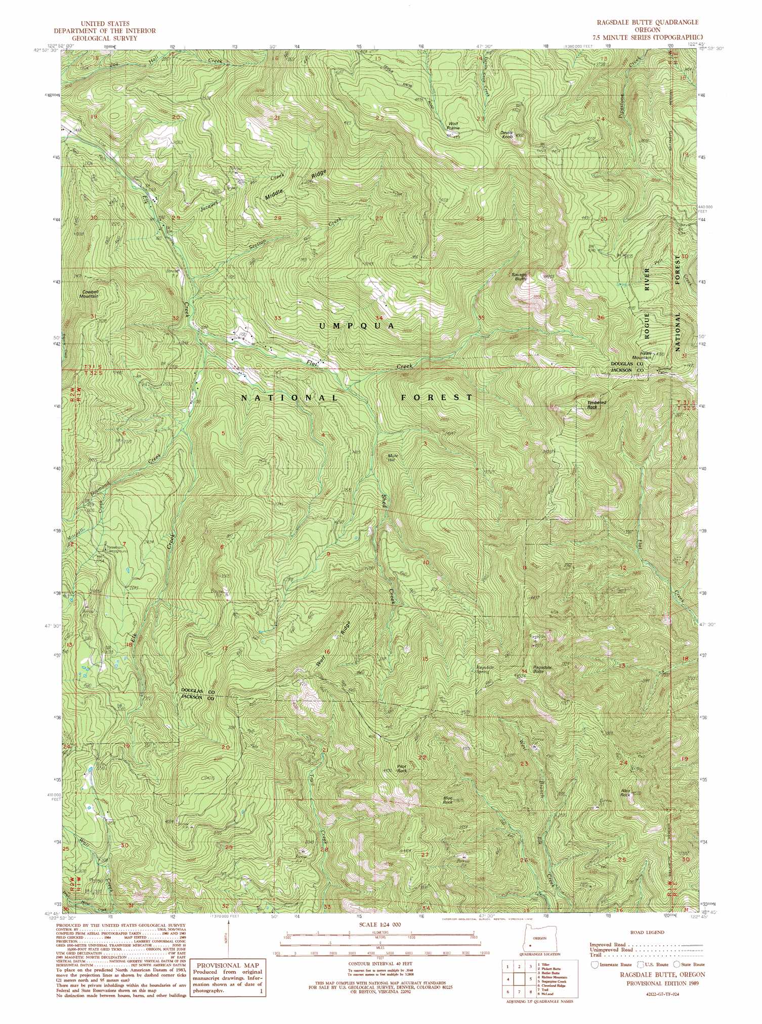
Ragsdale Butte Topo Map Oregon
To zoom in, hover over the map of Ragsdale Butte
USGS Topo Quad 42122g7 - 1:24,000 scale
| Topo Map Name: | Ragsdale Butte |
| USGS Topo Quad ID: | 42122g7 |
| Print Size: | ca. 21 1/4" wide x 27" high |
| Southeast Coordinates: | 42.75° N latitude / 122.75° W longitude |
| Map Center Coordinates: | 42.8125° N latitude / 122.8125° W longitude |
| U.S. State: | OR |
| Filename: | o42122g7.jpg |
| Download Map JPG Image: | Ragsdale Butte topo map 1:24,000 scale |
| Map Type: | Topographic |
| Topo Series: | 7.5´ |
| Map Scale: | 1:24,000 |
| Source of Map Images: | United States Geological Survey (USGS) |
| Alternate Map Versions: |
Ragsdale Butte OR 1989, updated 1990 Download PDF Buy paper map Ragsdale Butte OR 1998, updated 2000 Download PDF Buy paper map Ragsdale Butte OR 2011 Download PDF Buy paper map Ragsdale Butte OR 2014 Download PDF Buy paper map |
| FStopo: | US Forest Service topo Ragsdale Butte is available: Download FStopo PDF Download FStopo TIF |
1:24,000 Topo Quads surrounding Ragsdale Butte
White Rock |
Deadman Mountain |
Dumont Creek |
Acker Rock |
Buckeye Lake |
Milo |
Tiller |
Pickett Butte |
Butler Butte |
Abbott Butte |
Cedar Springs Mountain |
Richter Mountain |
Ragsdale Butte |
Sugarpine Creek |
Whetstone Point |
Skeleton Mountain |
Cleveland Ridge |
Trail |
Mcleod |
Cascade Gorge |
Mcconville Peak |
Boswell Mountain |
Shady Cove |
Obenchain Mountain |
Butte Falls |
> Back to 42122e1 at 1:100,000 scale
> Back to 42122a1 at 1:250,000 scale
> Back to U.S. Topo Maps home
Ragsdale Butte topo map: Gazetteer
Ragsdale Butte: Areas
Wolf Prairie elevation 1354m 4442′Ragsdale Butte: Cliffs
Savage Bluffs elevation 1241m 4071′Ragsdale Butte: Pillars
Alco Rock elevation 1345m 4412′Blue Rock elevation 1123m 3684′
Timbered Rock elevation 1415m 4642′
Ragsdale Butte: Ridges
Middle Ridge elevation 859m 2818′Wolf Ridge elevation 1187m 3894′
Ragsdale Butte: Springs
Oliver Spring elevation 1260m 4133′Ragsdale Spring elevation 1304m 4278′
Ragsdale Butte: Streams
Dead Horse Creek elevation 764m 2506′Diamond Creek elevation 562m 1843′
East Fork Elk Creek elevation 522m 1712′
Flat Creek elevation 516m 1692′
Growey Creek elevation 654m 2145′
Jacques Creek elevation 494m 1620′
Mitchell Creek elevation 710m 2329′
Section Creek elevation 513m 1683′
Shed Creek elevation 613m 2011′
Ragsdale Butte: Summits
Cowbell Mountain elevation 851m 2791′Devils Knob elevation 1482m 4862′
Hawk Mountain elevation 1451m 4760′
Mule Hill elevation 766m 2513′
Pilot Rock elevation 1363m 4471′
Ragsdale Butte elevation 1455m 4773′
Ragsdale Butte: Trails
Alco Trail elevation 1288m 4225′Rattlesnake Trail elevation 1260m 4133′
Rogue-Umpqua Divide Trail elevation 1192m 3910′
Tison Trail elevation 803m 2634′
Ragsdale Butte digital topo map on disk
Buy this Ragsdale Butte topo map showing relief, roads, GPS coordinates and other geographical features, as a high-resolution digital map file on DVD: