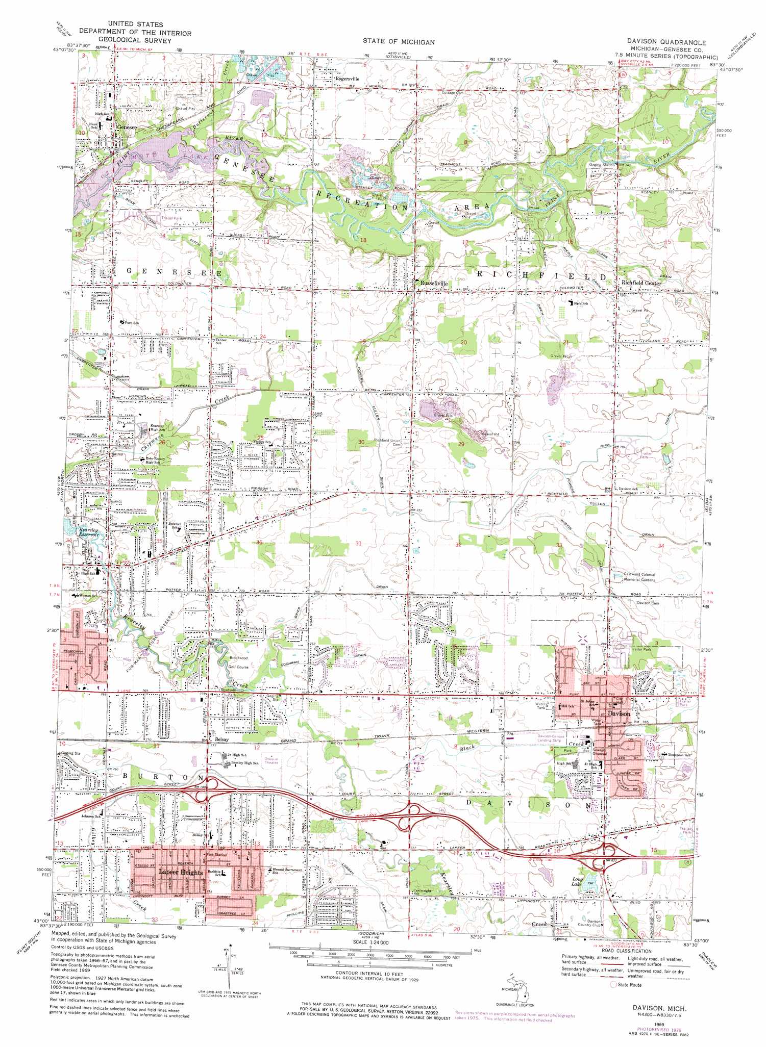
Davison Topo Map Michigan
To zoom in, hover over the map of Davison
USGS Topo Quad 43083a5 - 1:24,000 scale
| Topo Map Name: | Davison |
| USGS Topo Quad ID: | 43083a5 |
| Print Size: | ca. 21 1/4" wide x 27" high |
| Southeast Coordinates: | 43° N latitude / 83.5° W longitude |
| Map Center Coordinates: | 43.0625° N latitude / 83.5625° W longitude |
| U.S. State: | MI |
| Filename: | o43083a5.jpg |
| Download Map JPG Image: | Davison topo map 1:24,000 scale |
| Map Type: | Topographic |
| Topo Series: | 7.5´ |
| Map Scale: | 1:24,000 |
| Source of Map Images: | United States Geological Survey (USGS) |
| Alternate Map Versions: |
Davison MI 1969, updated 1971 Download PDF Buy paper map Davison MI 1969, updated 1976 Download PDF Buy paper map Davison MI 2011 Download PDF Buy paper map Davison MI 2014 Download PDF Buy paper map Davison MI 2017 Download PDF Buy paper map |
1:24,000 Topo Quads surrounding Davison
Birch Run North |
Frankenmuth |
Vassar |
Juniata |
Mayville |
Birch Run South |
Clio |
Otisville |
Columbiaville |
Barnes Lake |
Flushing |
Flint North |
Davison |
Elba |
Lapeer |
Swartz Creek |
Flint South |
Goodrich |
Hadley |
Metamora |
Linden |
Fenton |
Davisburg |
Ortonville |
Oxford |
> Back to 43083a1 at 1:100,000 scale
> Back to 43082a1 at 1:250,000 scale
> Back to U.S. Topo Maps home
Davison topo map: Gazetteer
Davison: Airports
Athelone Williams Memorial Airport elevation 237m 777′Davison: Canals
Austin Drain elevation 241m 790′Bear Swamp Ditch elevation 230m 754′
Bird Drain elevation 241m 790′
Brier Drain elevation 235m 770′
Cochran Drain elevation 231m 757′
Powers Cullen Drain elevation 235m 770′
Davison: Crossings
Interchange 141 elevation 237m 777′Interchange 143 elevation 240m 787′
Interchange 145 elevation 249m 816′
Davison: Lakes
Long Lake elevation 241m 790′Davison: Parks
Davison Regional Park elevation 237m 777′Davison Roadside County Park elevation 230m 754′
For-mar Nature Preserve elevation 232m 761′
Genesee Recreation Area elevation 223m 731′
Richfield County Park elevation 223m 731′
Davison: Populated Places
Belsay elevation 238m 780′Continental Estates Mobile Home Park elevation 244m 800′
Continental North Mobile Home Park elevation 243m 797′
Davison elevation 242m 793′
Genesee elevation 229m 751′
Lapeer Heights elevation 237m 777′
Richfield Center elevation 239m 784′
Rogersville elevation 230m 754′
Russellville elevation 225m 738′
Davison: Post Offices
Belsey Post Office (historical) elevation 238m 780′Davison Post Office elevation 244m 800′
Genesee Post Office elevation 228m 748′
Rogersville Post Office (historical) elevation 230m 754′
Davison: Streams
Black Creek elevation 232m 761′Butternut Creek elevation 222m 728′
Clark Drain elevation 223m 731′
Riegle Drain elevation 229m 751′
Zufelt Drain elevation 223m 731′
Davison digital topo map on disk
Buy this Davison topo map showing relief, roads, GPS coordinates and other geographical features, as a high-resolution digital map file on DVD:
 map DVD")