Flint South Topo Map Michigan
To zoom in, hover over the map of Flint South
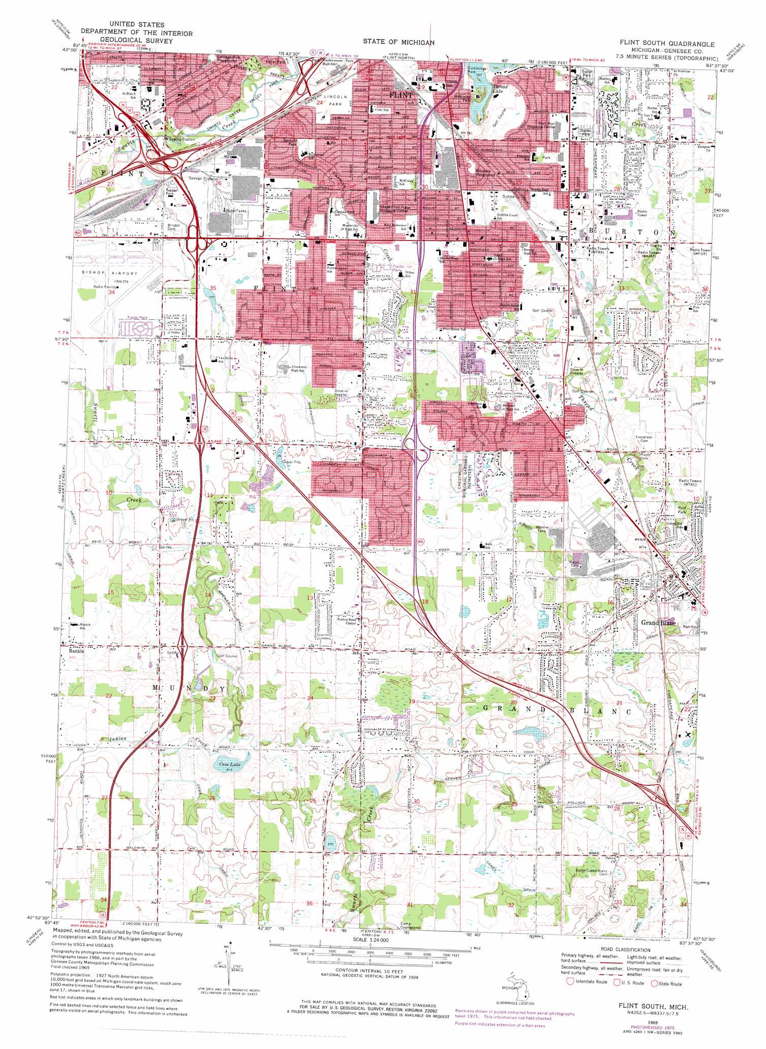
USGS Topo Quad 42083h6 - 1:24,000 scale
| Topo Map Name: | Flint South |
| USGS Topo Quad ID: | 42083h6 |
| Print Size: | ca. 21 1/4" wide x 27" high |
| Southeast Coordinates: | 42.875° N latitude / 83.625° W longitude |
| Map Center Coordinates: | 42.9375° N latitude / 83.6875° W longitude |
| U.S. State: | MI |
| Filename: | o42083h6.jpg |
| Download Map JPG Image: | Flint South topo map 1:24,000 scale |
| Map Type: | Topographic |
| Topo Series: | 7.5´ |
| Map Scale: | 1:24,000 |
| Source of Map Images: | United States Geological Survey (USGS) |
| Alternate Map Versions: |
Flint South MI 1969, updated 1971 Download PDF Buy paper map Flint South MI 1969, updated 1976 Download PDF Buy paper map Flint South MI 1969, updated 1976 Download PDF Buy paper map Flint South MI 2011 Download PDF Buy paper map Flint South MI 2014 Download PDF Buy paper map Flint South MI 2017 Download PDF Buy paper map |
1:24,000 Topo Quads surrounding Flint South
Montrose |
Birch Run South |
Clio |
Otisville |
Columbiaville |
New Lothrop |
Flushing |
Flint North |
Davison |
Elba |
Durand |
Swartz Creek |
Flint South |
Goodrich |
Hadley |
Byron |
Linden |
Fenton |
Davisburg |
Ortonville |
Oak Grove |
Hartland |
West Highland |
Highland |
Clarkston |
> Back to 42083e1 at 1:100,000 scale
> Back to 42082a1 at 1:250,000 scale
> Back to U.S. Topo Maps home
Flint South topo map: Gazetteer
Flint South: Airports
Bishop International Airport elevation 235m 770′Flint South: Canals
Brewer Drain elevation 244m 800′Call Drain elevation 236m 774′
Cames Drain elevation 264m 866′
Curtis Drain elevation 235m 770′
Dawe Drain elevation 256m 839′
Gibson Drain elevation 249m 816′
Gibson Drain elevation 238m 780′
Layman Drain elevation 255m 836′
Seaver Drain elevation 256m 839′
Sherwood Drain elevation 243m 797′
Flint South: Crossings
Interchange 108 elevation 273m 895′Interchange 109 elevation 257m 843′
Interchange 111 elevation 257m 843′
Interchange 116A elevation 231m 757′
Interchange 116B elevation 230m 754′
Interchange 117A elevation 234m 767′
Interchange 117B elevation 224m 734′
Interchange 133 elevation 230m 754′
Interchange 135 elevation 221m 725′
Interchange 2 elevation 247m 810′
Interchange 4 elevation 237m 777′
Interchange 5 elevation 229m 751′
Interchange 88 elevation 249m 816′
Interchange 90 elevation 244m 800′
Flint South: Lakes
Case Lake elevation 248m 813′Thread Lake elevation 227m 744′
Flint South: Parks
Broome Park elevation 230m 754′Congregational Church Historical Marker elevation 260m 853′
Creasy Bicentennial Park elevation 257m 843′
Cummings Park elevation 232m 761′
Davison Farmstead Historical Marker elevation 246m 807′
Farnumwood Park elevation 237m 777′
First Baptist Church Historical Marker elevation 251m 823′
General Motors Sit-Down Strike Historical Marker elevation 233m 764′
Gerholz Park elevation 228m 748′
Mason's Tavern Historical Marker elevation 244m 800′
McKinley Park elevation 234m 767′
Physicians Park elevation 256m 839′
Rust Park elevation 246m 807′
Swartz Creek Valley Park elevation 221m 725′
Water Tower Park elevation 238m 780′
Windiate Playground elevation 231m 757′
Flint South: Populated Places
Chateau of Grand Blanc Mobile Home Park elevation 262m 859′Chauteau Torrey Hills Mobile Home Park elevation 239m 784′
Delta Mobile Home Park elevation 234m 767′
Elms Mobile Home Park elevation 233m 764′
Fisherman's Cove Mobile Home Park elevation 236m 774′
Grand Blanc elevation 256m 839′
Hi-Way Trailer Court elevation 247m 810′
Maple Grove Mobile Home Park elevation 235m 770′
Park Meadow Estates Mobile Home Park elevation 248m 813′
Royal Mobile Home Park elevation 236m 774′
Tudor Estates Mobile Home Park elevation 236m 774′
Twin Meadows Mobile Home Park elevation 233m 764′
Villa Estates Mobile Home Park elevation 238m 780′
West Haven Mobile Home Park elevation 230m 754′
Flint South: Post Offices
Grand Blanc Post Office elevation 257m 843′Flint South: Streams
Carman Creek elevation 219m 718′Indian Creek elevation 244m 800′
Pierson Branch elevation 231m 757′
Flint South digital topo map on disk
Buy this Flint South topo map showing relief, roads, GPS coordinates and other geographical features, as a high-resolution digital map file on DVD:
 map DVD")