Fond Du Lac Topo Map Wisconsin
To zoom in, hover over the map of Fond Du Lac
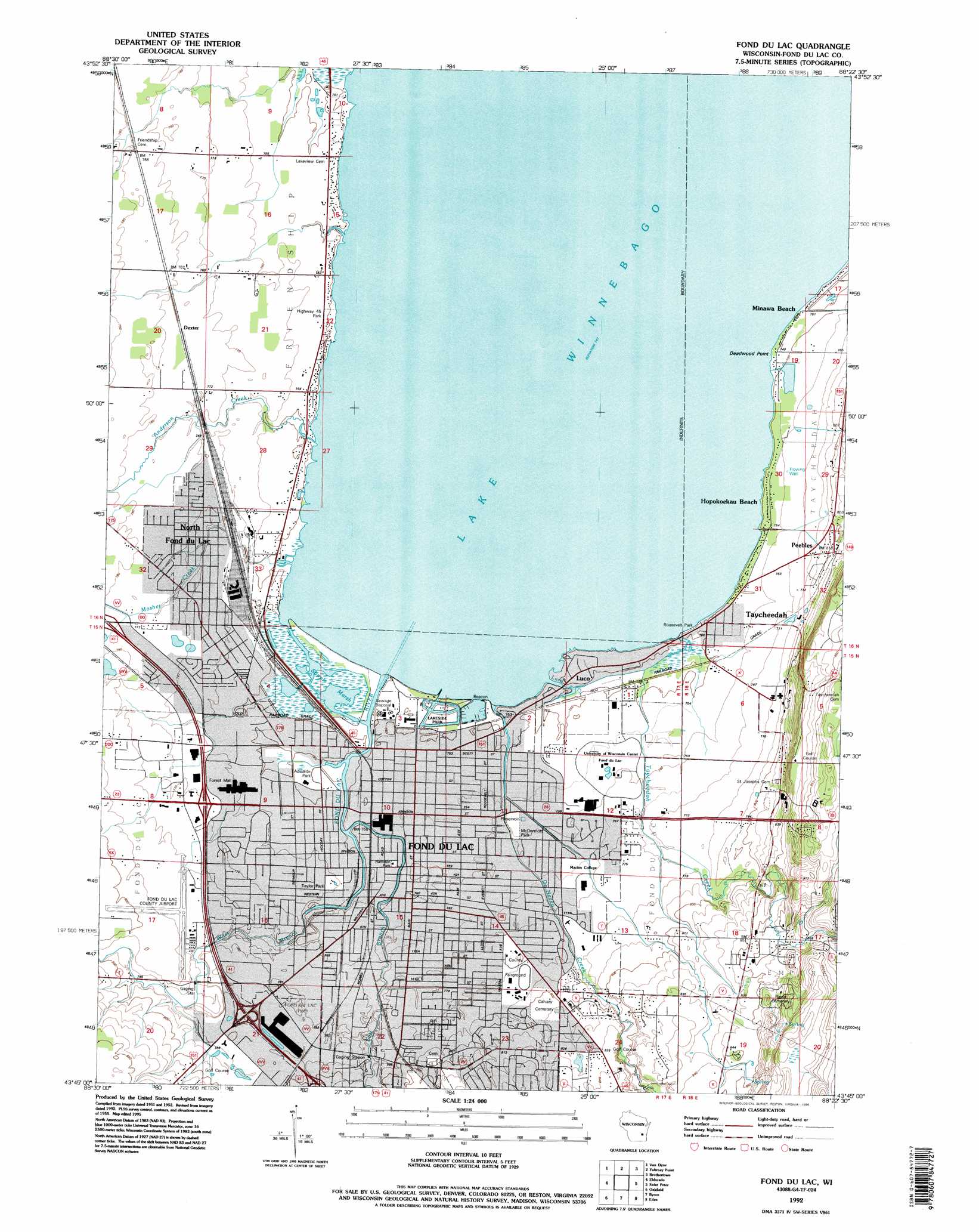
USGS Topo Quad 43088g4 - 1:24,000 scale
| Topo Map Name: | Fond Du Lac |
| USGS Topo Quad ID: | 43088g4 |
| Print Size: | ca. 21 1/4" wide x 27" high |
| Southeast Coordinates: | 43.75° N latitude / 88.375° W longitude |
| Map Center Coordinates: | 43.8125° N latitude / 88.4375° W longitude |
| U.S. State: | WI |
| Filename: | o43088g4.jpg |
| Download Map JPG Image: | Fond Du Lac topo map 1:24,000 scale |
| Map Type: | Topographic |
| Topo Series: | 7.5´ |
| Map Scale: | 1:24,000 |
| Source of Map Images: | United States Geological Survey (USGS) |
| Alternate Map Versions: |
Fond Du Lac WI 1955, updated 1966 Download PDF Buy paper map Fond Du Lac WI 1955, updated 1985 Download PDF Buy paper map Fond Du Lac WI 1992, updated 1996 Download PDF Buy paper map Fond du Lac WI 2010 Download PDF Buy paper map Fond du Lac WI 2013 Download PDF Buy paper map Fond du Lac WI 2015 Download PDF Buy paper map |
1:24,000 Topo Quads surrounding Fond Du Lac
Omro |
Oshkosh |
Indian Point |
Stockbridge |
Chilton |
Pickett |
Van Dyne |
Fahrney Point |
Brothertown |
Marytown |
Rosendale |
Eldorado |
Fond Du Lac |
Saint Peter |
Saint Cloud |
Waupun North |
Oakfield |
Byron |
Eden |
Dundee |
Waupun South |
Mayville North |
Lomira |
Campbellsport |
Kewaskum |
> Back to 43088e1 at 1:100,000 scale
> Back to 43088a1 at 1:250,000 scale
> Back to U.S. Topo Maps home
Fond Du Lac topo map: Gazetteer
Fond Du Lac: Airports
Fond du Lac County Airport elevation 240m 787′Fond Du Lac: Bays
Supple Marsh elevation 228m 748′Fond Du Lac: Canals
South Ditch elevation 236m 774′Fond Du Lac: Capes
Deadwood Point elevation 228m 748′Fond Du Lac: Crossings
Interchange 101 elevation 239m 784′Interchange 97A elevation 244m 800′
Interchange 97B elevation 242m 793′
Interchange 99 elevation 235m 770′
Fond Du Lac: Harbors
Lighthouse Harbor elevation 228m 748′Fond Du Lac: Parks
Adelaide Park elevation 229m 751′Bellvue Park elevation 251m 823′
Brookfield Park elevation 238m 780′
Buttermilk Creek Park elevation 239m 784′
Fond du Lac County Fairgrounds elevation 238m 780′
Franklin Park elevation 233m 764′
Fruthfield Park elevation 231m 757′
Hamilton Park elevation 229m 751′
Jefferson Park elevation 233m 764′
Lakeside Park elevation 229m 751′
Lallier Park elevation 235m 770′
LeMieux Park elevation 234m 767′
Linden Street Historic District elevation 232m 761′
McDermott Park elevation 230m 754′
Playmore Park elevation 231m 757′
Roosevelt Park elevation 229m 751′
Russell Park elevation 233m 764′
Taylor Park elevation 232m 761′
Village Park elevation 235m 770′
Fond Du Lac: Populated Places
Dexter elevation 237m 777′Fond du Lac elevation 232m 761′
Hopokoekau Beach elevation 229m 751′
Luco elevation 229m 751′
Minawa Beach elevation 229m 751′
North Fond du Lac elevation 234m 767′
Peebles elevation 248m 813′
Taycheedah elevation 229m 751′
Fond Du Lac: Post Offices
Fond du Lac Post Office elevation 229m 751′Fond Du Lac: Streams
Anderson Creek elevation 228m 748′De Neveu Creek elevation 228m 748′
East Branch Fond Du Lac River elevation 228m 748′
Fond du Lac River elevation 228m 748′
Luco Creek elevation 228m 748′
Mosher Creek elevation 228m 748′
Taycheedah Creek elevation 228m 748′
West Branch Fond Du Lac River elevation 228m 748′
Fond Du Lac digital topo map on disk
Buy this Fond Du Lac topo map showing relief, roads, GPS coordinates and other geographical features, as a high-resolution digital map file on DVD: