Waunakee Topo Map Wisconsin
To zoom in, hover over the map of Waunakee
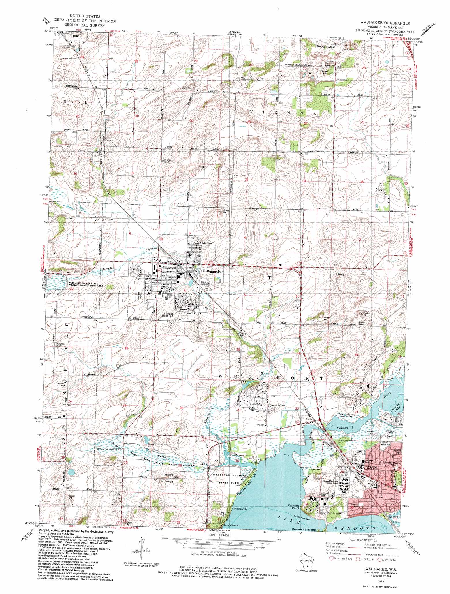
USGS Topo Quad 43089b4 - 1:24,000 scale
| Topo Map Name: | Waunakee |
| USGS Topo Quad ID: | 43089b4 |
| Print Size: | ca. 21 1/4" wide x 27" high |
| Southeast Coordinates: | 43.125° N latitude / 89.375° W longitude |
| Map Center Coordinates: | 43.1875° N latitude / 89.4375° W longitude |
| U.S. State: | WI |
| Filename: | o43089b4.jpg |
| Download Map JPG Image: | Waunakee topo map 1:24,000 scale |
| Map Type: | Topographic |
| Topo Series: | 7.5´ |
| Map Scale: | 1:24,000 |
| Source of Map Images: | United States Geological Survey (USGS) |
| Alternate Map Versions: |
Waunakee WI 1959, updated 1960 Download PDF Buy paper map Waunakee WI 1959, updated 1970 Download PDF Buy paper map Waunakee WI 1959, updated 1975 Download PDF Buy paper map Waunakee WI 1983, updated 1984 Download PDF Buy paper map Waunakee WI 2010 Download PDF Buy paper map Waunakee WI 2013 Download PDF Buy paper map Waunakee WI 2016 Download PDF Buy paper map |
1:24,000 Topo Quads surrounding Waunakee
Baraboo |
Durwards Glen |
Poynette |
Wyocena |
Rio |
Sauk City |
Lodi |
Arlington |
Morrisonville |
North Bristol |
Black Earth |
Springfield Corners |
Waunakee |
De Forest |
Sun Prairie |
Cross Plains |
Middleton |
Madison West |
Madison East |
Cottage Grove |
Mount Vernon |
Verona |
Oregon |
Rutland |
Stoughton |
> Back to 43089a1 at 1:100,000 scale
> Back to 43088a1 at 1:250,000 scale
> Back to U.S. Topo Maps home
Waunakee topo map: Gazetteer
Waunakee: Airports
Dane Airport elevation 317m 1040′Waunakee Airport elevation 277m 908′
Waunkakee Landing Field elevation 284m 931′
Waunakee: Areas
Westport Drumlin Prairie elevation 303m 994′Waunakee: Capes
Farwells Point elevation 263m 862′Waunakee: Lakes
Cherokee Lake elevation 259m 849′Waunakee: Parks
Centennial Park elevation 289m 948′Dorn Creek Marsh State Fishery Area elevation 263m 862′
Governor Nelson State Park elevation 261m 856′
Nerdahl Park elevation 270m 885′
Northland Manor Park elevation 265m 869′
Wheeler Heights Park elevation 287m 941′
Yahara Heights County Park elevation 264m 866′
Waunakee: Populated Places
Catfish (historical) elevation 261m 856′Kingsley Corners elevation 293m 961′
Mendota elevation 279m 915′
Norway Grove elevation 302m 990′
Waunakee elevation 283m 928′
Waunakee: Streams
Dorn Creek elevation 259m 849′Sixmile Creek elevation 259m 849′
Waunakee digital topo map on disk
Buy this Waunakee topo map showing relief, roads, GPS coordinates and other geographical features, as a high-resolution digital map file on DVD: