Cedarbutte Topo Map South Dakota
To zoom in, hover over the map of Cedarbutte
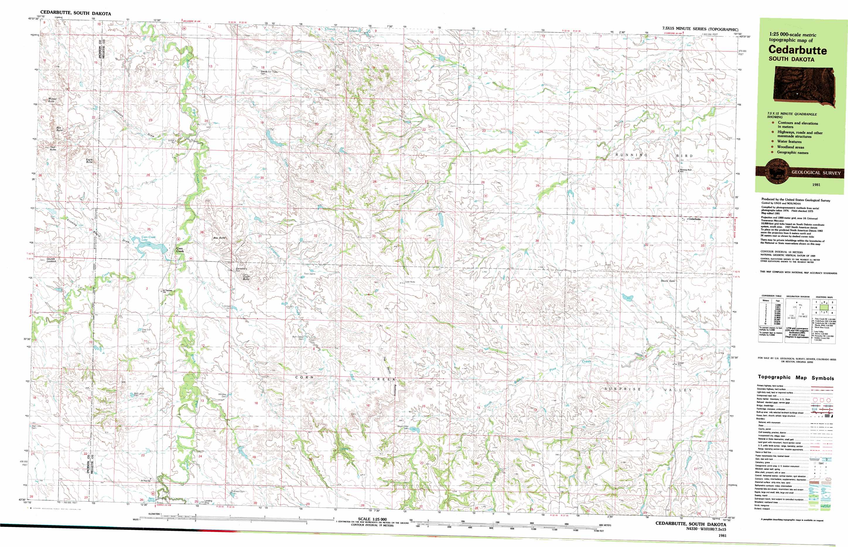
USGS Topo Quad 43101e1 - 1:25,000 scale
| Topo Map Name: | Cedarbutte |
| USGS Topo Quad ID: | 43101e1 |
| Print Size: | ca. 39" wide x 24" high |
| Southeast Coordinates: | 43.5° N latitude / 101° W longitude |
| Map Center Coordinates: | 43.5625° N latitude / 101.125° W longitude |
| U.S. State: | SD |
| Filename: | k43101e1.jpg |
| Download Map JPG Image: | Cedarbutte topo map 1:25,000 scale |
| Map Type: | Topographic |
| Topo Series: | 7.5´x15´ |
| Map Scale: | 1:25,000 |
| Source of Map Images: | United States Geological Survey (USGS) |
| Alternate Map Versions: |
Cedar Butte SD 1981, updated 1981 Download PDF Buy paper map |
1:24,000 Topo Quads surrounding Cedarbutte
Belvidere |
Stamford Sw |
Stamford Se |
Okaton Sw |
Okaton Se |
Pass Creek Ne |
Cedar Butte Nw |
Cedar Butte Ne |
Murdo 3 Nw |
Murdo 3 Ne |
Short Bow Creek East |
Cedarbutte |
Murdo 3 Sw |
White River West |
|
Long Valley Nw |
Norris |
Parmelee Ne |
Soldier Creek Nw |
Soldier Creek Ne |
Blackpipe |
Eagle Mans Butte |
Parmelee |
Soldier Creek |
Soldier Creek Se |
> Back to 43101e1 at 1:100,000 scale
> Back to 43100a1 at 1:250,000 scale
> Back to U.S. Topo Maps home
Cedarbutte topo map: Gazetteer
Cedarbutte: Arroyos
Johnson Draw elevation 700m 2296′Klinking Beard Draw elevation 741m 2431′
Cedarbutte: Dams
Anderson Number 1 Dam elevation 736m 2414′Bad Lands Dam elevation 764m 2506′
Baummiller Dam elevation 758m 2486′
Bronson Number 1 Dam elevation 802m 2631′
Bronson Number 2 Dam elevation 793m 2601′
Bullhead Dam elevation 770m 2526′
Deep Dam elevation 753m 2470′
Dog Eye Dam elevation 758m 2486′
Gregor Dam elevation 745m 2444′
High Line Dam elevation 776m 2545′
Huber Number 1 Dam elevation 752m 2467′
John Catron Junior Number 1 Dam elevation 688m 2257′
Paul Berry Dam elevation 759m 2490′
Phipps Number 1 Dam elevation 729m 2391′
Rassmussen Number 1 Dam elevation 741m 2431′
Rum Camp Dam elevation 751m 2463′
Twin Dams elevation 743m 2437′
Whistler Dam elevation 758m 2486′
Cedarbutte: Gaps
Devils Gate elevation 705m 2312′Cedarbutte: Populated Places
Cedar Butte elevation 718m 2355′Corn Creek elevation 721m 2365′
Cedarbutte: Reservoirs
Corn Creek Lake elevation 722m 2368′Cedarbutte: Ridges
The Devils Backbone elevation 779m 2555′Cedarbutte: Springs
Berry Spring elevation 751m 2463′Cedarbutte: Streams
Corn Creek elevation 720m 2362′Dry Creek elevation 750m 2460′
Langston Creek elevation 708m 2322′
Owl Creek elevation 696m 2283′
Cedarbutte: Summits
Box Butte elevation 775m 2542′Bus Butte elevation 778m 2552′
Cemetery Hill elevation 771m 2529′
Coyote Lookout elevation 783m 2568′
Cross Butte elevation 805m 2641′
Eagle Butte elevation 781m 2562′
Eagle Butte elevation 771m 2529′
Midget Butte elevation 754m 2473′
Teat Butte elevation 783m 2568′
Cedarbutte digital topo map on disk
Buy this Cedarbutte topo map showing relief, roads, GPS coordinates and other geographical features, as a high-resolution digital map file on DVD:
Eastern North Dakota & Eastern South Dakota
Buy digital topo maps: Eastern North Dakota & Eastern South Dakota