Cedar Butte Nw Topo Map South Dakota
To zoom in, hover over the map of Cedar Butte Nw
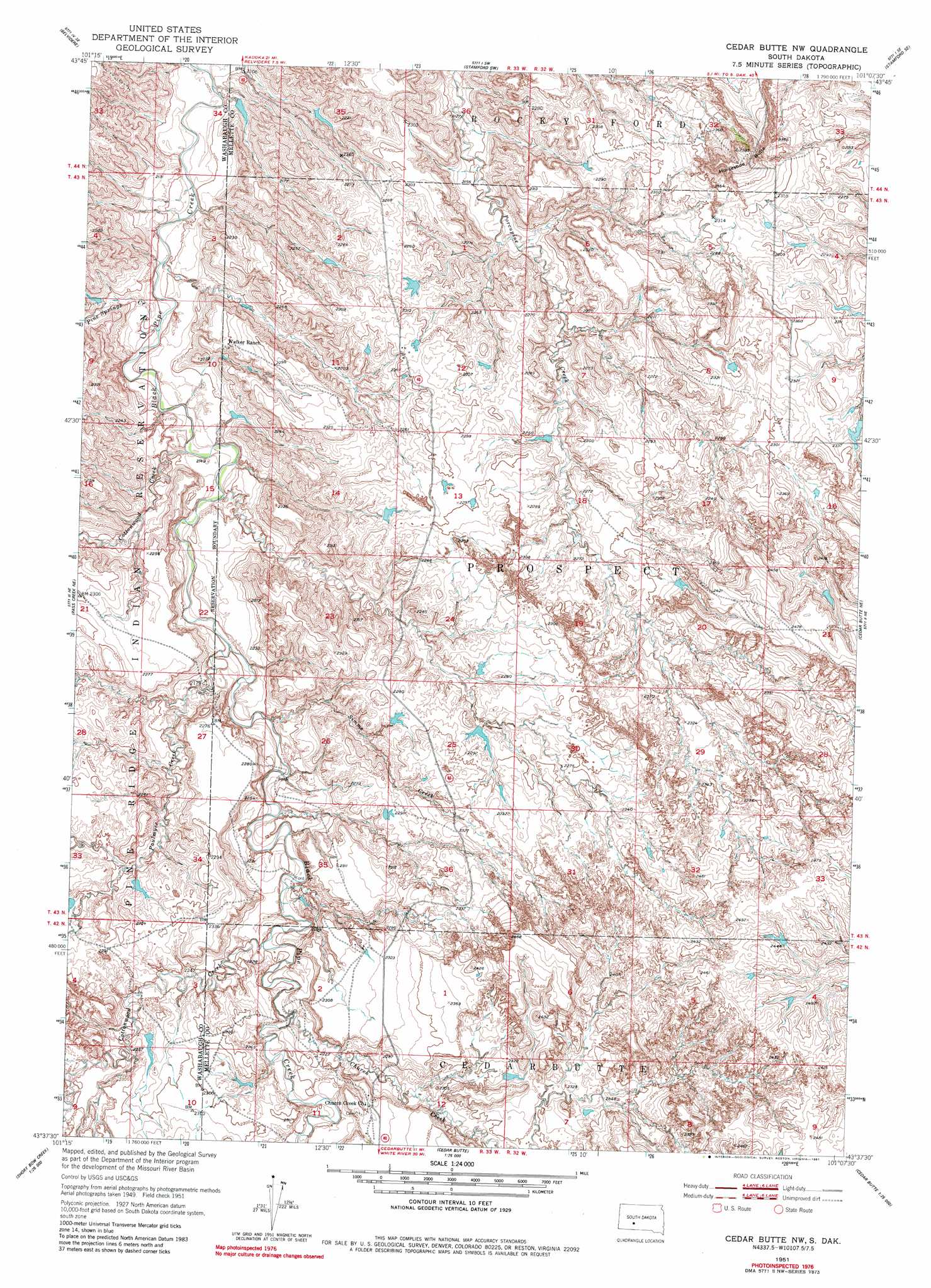
USGS Topo Quad 43101f2 - 1:24,000 scale
| Topo Map Name: | Cedar Butte Nw |
| USGS Topo Quad ID: | 43101f2 |
| Print Size: | ca. 21 1/4" wide x 27" high |
| Southeast Coordinates: | 43.625° N latitude / 101.125° W longitude |
| Map Center Coordinates: | 43.6875° N latitude / 101.1875° W longitude |
| U.S. State: | SD |
| Filename: | o43101f2.jpg |
| Download Map JPG Image: | Cedar Butte Nw topo map 1:24,000 scale |
| Map Type: | Topographic |
| Topo Series: | 7.5´ |
| Map Scale: | 1:24,000 |
| Source of Map Images: | United States Geological Survey (USGS) |
| Alternate Map Versions: |
Cedar Butte NW SD 1951, updated 1953 Download PDF Buy paper map Cedar Butte NW SD 1951, updated 1981 Download PDF Buy paper map Cedar Butte NW SD 2012 Download PDF Buy paper map Cedar Butte NW SD 2015 Download PDF Buy paper map |
1:24,000 Topo Quads surrounding Cedar Butte Nw
Belvidere Nw |
Belvidere Ne |
Stamford Nw |
Stamford |
Okaton |
Belvidere Sw |
Belvidere |
Stamford Sw |
Stamford Se |
Okaton Sw |
Pass Creek Nw |
Pass Creek Ne |
Cedar Butte Nw |
Cedar Butte Ne |
Murdo 3 Nw |
Short Bow Creek East |
Cedarbutte |
Murdo 3 Sw |
||
Long Valley Nw |
Norris |
Parmelee Ne |
Soldier Creek Nw |
> Back to 43101e1 at 1:100,000 scale
> Back to 43100a1 at 1:250,000 scale
> Back to U.S. Topo Maps home
Cedar Butte Nw topo map: Gazetteer
Cedar Butte Nw: Streams
Church Creek elevation 674m 2211′Cottonwood Creek elevation 643m 2109′
Cottonwood Creek elevation 671m 2201′
Paulmyer Creek elevation 650m 2132′
Pine Springs Creek elevation 637m 2089′
Simms Creek elevation 654m 2145′
Cedar Butte Nw: Summits
Horseshoe Butte elevation 772m 2532′Cedar Butte Nw digital topo map on disk
Buy this Cedar Butte Nw topo map showing relief, roads, GPS coordinates and other geographical features, as a high-resolution digital map file on DVD:
Eastern North Dakota & Eastern South Dakota
Buy digital topo maps: Eastern North Dakota & Eastern South Dakota