Fort Reno Se Topo Map Wyoming
To zoom in, hover over the map of Fort Reno Se
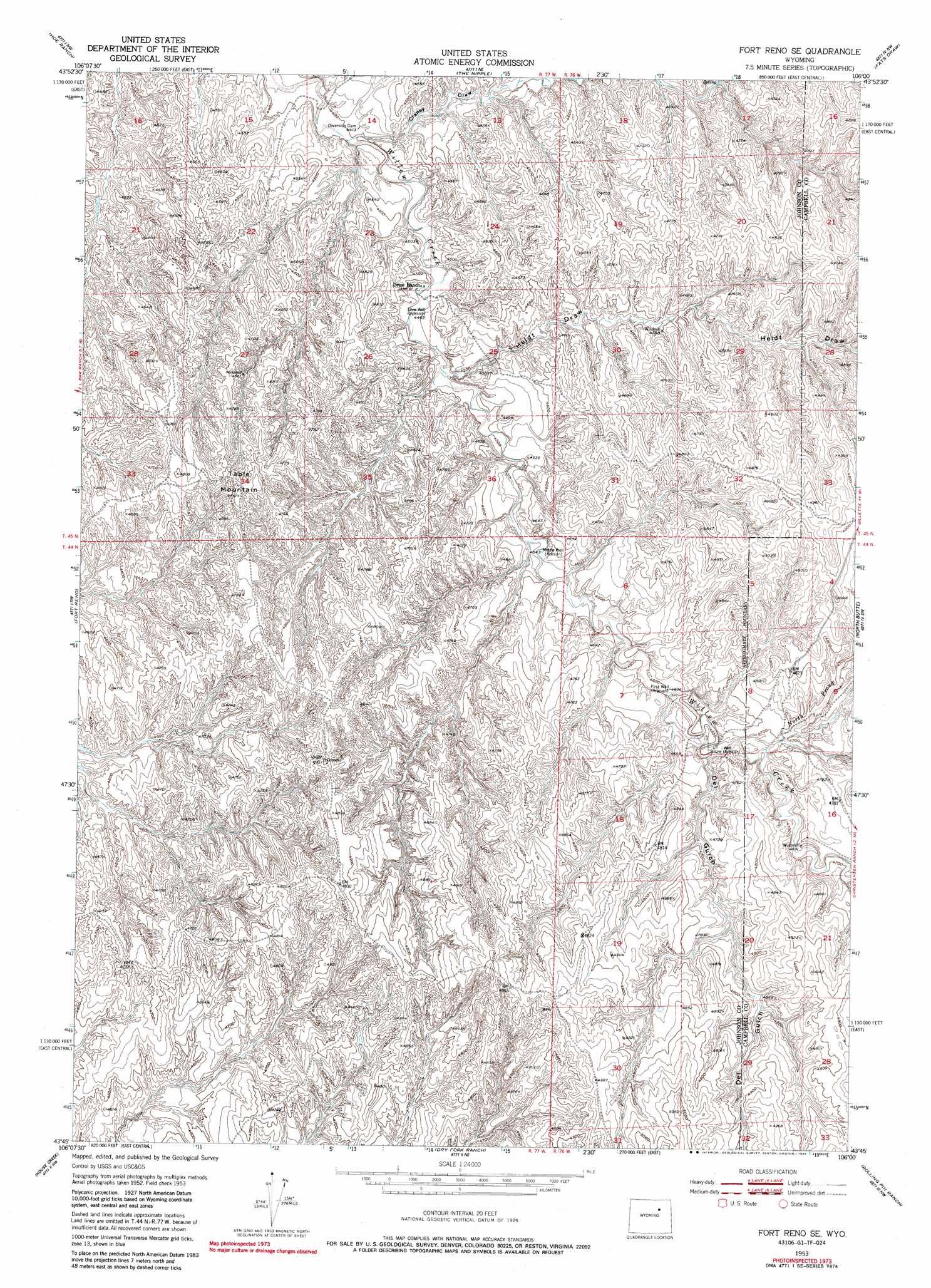
USGS Topo Quad 43106g1 - 1:24,000 scale
| Topo Map Name: | Fort Reno Se |
| USGS Topo Quad ID: | 43106g1 |
| Print Size: | ca. 21 1/4" wide x 27" high |
| Southeast Coordinates: | 43.75° N latitude / 106° W longitude |
| Map Center Coordinates: | 43.8125° N latitude / 106.0625° W longitude |
| U.S. State: | WY |
| Filename: | o43106g1.jpg |
| Download Map JPG Image: | Fort Reno Se topo map 1:24,000 scale |
| Map Type: | Topographic |
| Topo Series: | 7.5´ |
| Map Scale: | 1:24,000 |
| Source of Map Images: | United States Geological Survey (USGS) |
| Alternate Map Versions: |
Fort Reno SE WY 1953, updated 1954 Download PDF Buy paper map Fort Reno SE WY 1953, updated 1958 Download PDF Buy paper map Fort Reno SE WY 1953, updated 1978 Download PDF Buy paper map Fort Reno SE WY 1953, updated 1985 Download PDF Buy paper map Fort Reno SE WY 2012 Download PDF Buy paper map Fort Reno SE WY 2015 Download PDF Buy paper map |
1:24,000 Topo Quads surrounding Fort Reno Se
Boon |
Bowman Flat |
Negro Butte |
Bogie Draw |
Double Tanks |
Provence Ranch |
Hoe Ranch |
The Nipple |
Fats Draw |
Wags Pinnacle |
Soldier Creek |
Fort Reno |
Fort Reno Se |
North Butte |
Savageton |
Sussex |
House Creek |
Dry Fork Ranch |
Rolling Pin Ranch |
South Butte |
Dead Woman Crossing |
Linch |
Taylor Ranch |
Artesian Draw |
Pine Tree |
> Back to 43106e1 at 1:100,000 scale
> Back to 43106a1 at 1:250,000 scale
> Back to U.S. Topo Maps home
Fort Reno Se topo map: Gazetteer
Fort Reno Se: Mines
A-Number Ninety-three Mine elevation 1468m 4816′Channel Deposit Mine elevation 1425m 4675′
Charlite Ore Body Mine elevation 1399m 4589′
Christensen Lease Mine elevation 1484m 4868′
Christensen Lease Number Two Mine elevation 1459m 4786′
Christianson Ranch Joint Venture Mine elevation 1387m 4550′
Frank Claims elevation 1434m 4704′
Jack Christansen Mine elevation 1464m 4803′
Jane One Mine elevation 1423m 4668′
John Christian Pit elevation 1430m 4691′
Karl Three Claim elevation 1426m 4678′
Kerr-McGee Stan Seven and Eight Claims elevation 1474m 4835′
Lem Three and Four Moe Three and Four Claims elevation 1459m 4786′
Moe Fourteen Mine elevation 1433m 4701′
Ole Claims Mine elevation 1422m 4665′
Opal Claims elevation 1414m 4639′
Quincy Claims elevation 1415m 4642′
Ray Claims elevation 1419m 4655′
Sad Sack Six Mine elevation 1430m 4691′
South Peak Mining Property Mine elevation 1453m 4767′
Fort Reno Se: Streams
North Prong Willow Creek elevation 1416m 4645′Fort Reno Se: Summits
Table Mountain elevation 1460m 4790′Fort Reno Se: Valleys
Craney Draw elevation 1340m 4396′Del Gulch elevation 1407m 4616′
Heidt Draw elevation 1364m 4475′
Fort Reno Se: Wells
Drew Well elevation 1372m 4501′First Well elevation 1402m 4599′
Middle Well elevation 1391m 4563′
Fort Reno Se digital topo map on disk
Buy this Fort Reno Se topo map showing relief, roads, GPS coordinates and other geographical features, as a high-resolution digital map file on DVD:
Eastern Wyoming & Western South Dakota
Buy digital topo maps: Eastern Wyoming & Western South Dakota