Sussex Topo Map Wyoming
To zoom in, hover over the map of Sussex
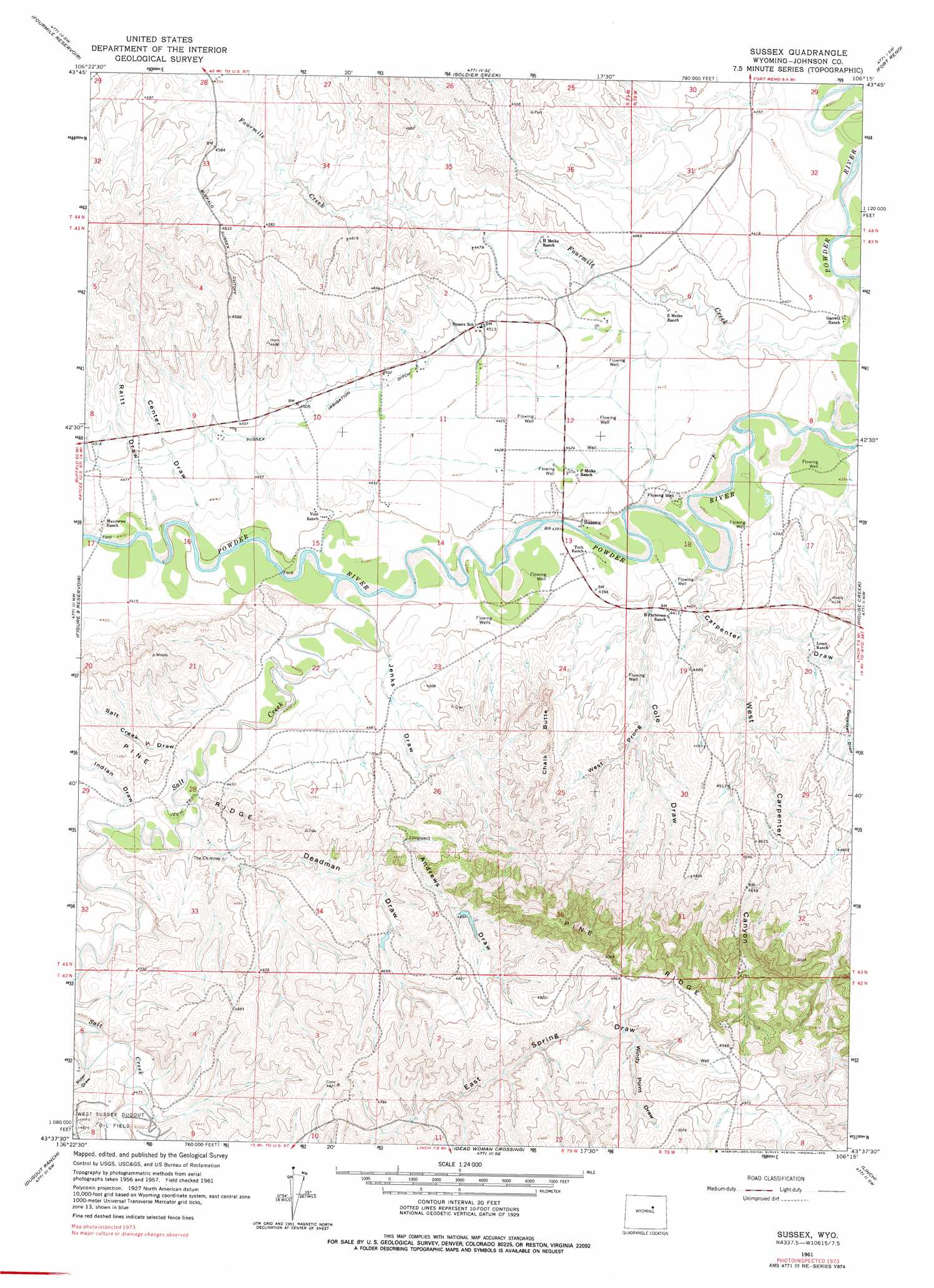
USGS Topo Quad 43106f3 - 1:24,000 scale
| Topo Map Name: | Sussex |
| USGS Topo Quad ID: | 43106f3 |
| Print Size: | ca. 21 1/4" wide x 27" high |
| Southeast Coordinates: | 43.625° N latitude / 106.25° W longitude |
| Map Center Coordinates: | 43.6875° N latitude / 106.3125° W longitude |
| U.S. State: | WY |
| Filename: | o43106f3.jpg |
| Download Map JPG Image: | Sussex topo map 1:24,000 scale |
| Map Type: | Topographic |
| Topo Series: | 7.5´ |
| Map Scale: | 1:24,000 |
| Source of Map Images: | United States Geological Survey (USGS) |
| Alternate Map Versions: |
Sussex WY 1961, updated 1965 Download PDF Buy paper map Sussex WY 1961, updated 1978 Download PDF Buy paper map Sussex WY 2012 Download PDF Buy paper map Sussex WY 2015 Download PDF Buy paper map |
1:24,000 Topo Quads surrounding Sussex
Antelope Draw |
Elaine Draw |
Provence Ranch |
Hoe Ranch |
The Nipple |
Dry Creek Reservoir |
Fourmile Reservoir |
Soldier Creek |
Fort Reno |
Fort Reno Se |
Kaycee Ne |
Figure 8 Reservoir |
Sussex |
House Creek |
Dry Fork Ranch |
Wall Creek |
Dugout Ranch |
Dead Woman Crossing |
Linch |
Taylor Ranch |
Salt Canyon |
Government Creek |
Midwest |
Edgerton |
Sawmill Canyon |
> Back to 43106e1 at 1:100,000 scale
> Back to 43106a1 at 1:250,000 scale
> Back to U.S. Topo Maps home
Sussex topo map: Gazetteer
Sussex: Dams
Patrick Dam elevation 1485m 4872′Sussex: Mines
Meike Pit Number Three Mine elevation 1327m 4353′Skiles Pit Number One elevation 1402m 4599′
Sussex: Pillars
The Chimney elevation 1354m 4442′Sussex: Populated Places
Sussex elevation 1336m 4383′Sussex: Reservoirs
Patrick Reservoir elevation 1485m 4872′Sussex: Streams
Fourmile Creek elevation 1320m 4330′Salt Creek elevation 1337m 4386′
Sussex: Summits
Chalk Butte elevation 1440m 4724′Sussex: Valleys
Andrews Draw elevation 1385m 4543′Carpenter Draw elevation 1329m 4360′
Center Draw elevation 1356m 4448′
Cole Draw elevation 1336m 4383′
Deadman Draw elevation 1348m 4422′
Indian Draw elevation 1351m 4432′
Jenks Draw elevation 1340m 4396′
Raitt Draw elevation 1347m 4419′
Rider Draw elevation 1366m 4481′
Salt Creek V Draw elevation 1353m 4438′
West Carpenter Canyon elevation 1345m 4412′
West Prong Cole Draw elevation 1358m 4455′
Windy Point Draw elevation 1476m 4842′
Sussex digital topo map on disk
Buy this Sussex topo map showing relief, roads, GPS coordinates and other geographical features, as a high-resolution digital map file on DVD:
Eastern Wyoming & Western South Dakota
Buy digital topo maps: Eastern Wyoming & Western South Dakota