Silica Mountain Topo Map Oregon
To zoom in, hover over the map of Silica Mountain
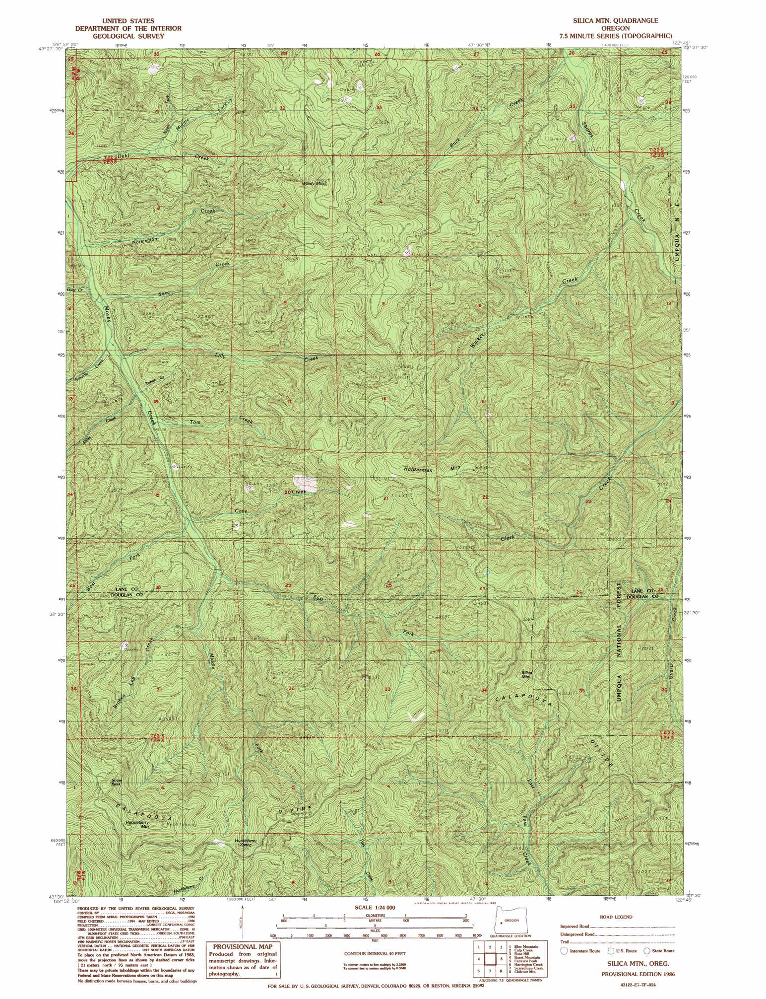
USGS Topo Quad 43122e7 - 1:24,000 scale
| Topo Map Name: | Silica Mountain |
| USGS Topo Quad ID: | 43122e7 |
| Print Size: | ca. 21 1/4" wide x 27" high |
| Southeast Coordinates: | 43.5° N latitude / 122.75° W longitude |
| Map Center Coordinates: | 43.5625° N latitude / 122.8125° W longitude |
| U.S. State: | OR |
| Filename: | o43122e7.jpg |
| Download Map JPG Image: | Silica Mountain topo map 1:24,000 scale |
| Map Type: | Topographic |
| Topo Series: | 7.5´ |
| Map Scale: | 1:24,000 |
| Source of Map Images: | United States Geological Survey (USGS) |
| Alternate Map Versions: |
Silica Mtn OR 1986, updated 1986 Download PDF Buy paper map Silica Mountain OR 1998, updated 2000 Download PDF Buy paper map Silica Mountain OR 2011 Download PDF Buy paper map Silica Mountain OR 2014 Download PDF Buy paper map |
| FStopo: | US Forest Service topo Silica Mountain is available: Download FStopo PDF Download FStopo TIF |
1:24,000 Topo Quads surrounding Silica Mountain
Cottage Grove |
Dorena Lake |
Kloster Mountain |
Mount June |
Westfir West |
Cottage Grove Lake |
Blue Mountain |
Culp Creek |
Rose Hill |
Holland Point |
Harness Mountain |
Burnt Mountain |
Silica Mountain |
Fairview Peak |
Bearbones Mountain |
Hinkle Creek |
Harrington Creek |
Scaredman Creek |
Chilcoot Mountain |
Reynolds Ridge |
Glide |
Old Fairview |
Mace Mountain |
Steamboat |
Illahee Rock |
> Back to 43122e1 at 1:100,000 scale
> Back to 43122a1 at 1:250,000 scale
> Back to U.S. Topo Maps home
Silica Mountain topo map: Gazetteer
Silica Mountain: Ridges
Calapooya Divide elevation 987m 3238′Silica Mountain: Springs
Huckleberry Spring elevation 1187m 3894′Silica Mountain: Streams
Broken Leg Creek elevation 526m 1725′Brownie Creek elevation 406m 1332′
Buck Creek elevation 395m 1295′
Cove Creek elevation 449m 1473′
East Fork Mosby Creek elevation 459m 1505′
Gray Creek elevation 392m 1286′
Lick Creek elevation 395m 1295′
Lilly Creek elevation 413m 1354′
Middle Fork Dahl Creek elevation 508m 1666′
Middle Fork Mosby Creek elevation 474m 1555′
Miles Creek elevation 416m 1364′
North Fork Dahl Creek elevation 529m 1735′
Norwegian Creek elevation 392m 1286′
Shea Creek elevation 406m 1332′
Tom Creek elevation 429m 1407′
Tones Creek elevation 415m 1361′
Walker Creek elevation 425m 1394′
West Fork Mosby Creek elevation 459m 1505′
White Creek elevation 456m 1496′
Silica Mountain: Summits
Holderman Mountain elevation 1321m 4333′Huckleberry Mountain elevation 1443m 4734′
Silica Mountain elevation 1284m 4212′
Snow Peak elevation 1386m 4547′
Windy Mountain elevation 1200m 3937′
Silica Mountain: Trails
Pass Creek Trail elevation 1156m 3792′Silica Trail elevation 1019m 3343′
Silica Mountain digital topo map on disk
Buy this Silica Mountain topo map showing relief, roads, GPS coordinates and other geographical features, as a high-resolution digital map file on DVD: