Whiteface Mountain Topo Map Vermont
To zoom in, hover over the map of Whiteface Mountain
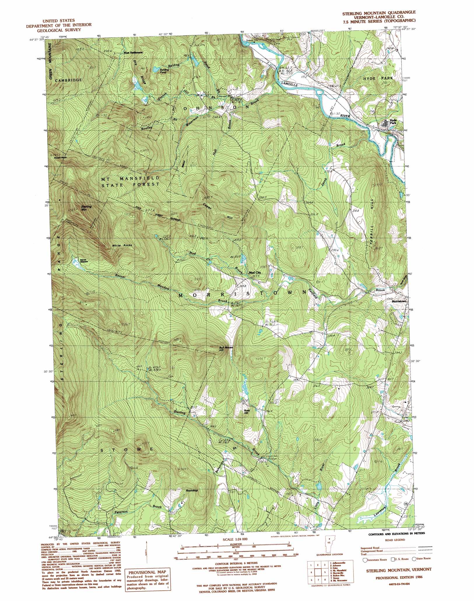
USGS Topo Quad 44072e6 - 1:24,000 scale
| Topo Map Name: | Whiteface Mountain |
| USGS Topo Quad ID: | 44072e6 |
| Print Size: | ca. 21 1/4" wide x 27" high |
| Southeast Coordinates: | 44.5° N latitude / 72.625° W longitude |
| Map Center Coordinates: | 44.5625° N latitude / 72.6875° W longitude |
| U.S. State: | VT |
| Filename: | o44072e6.jpg |
| Download Map JPG Image: | Whiteface Mountain topo map 1:24,000 scale |
| Map Type: | Topographic |
| Topo Series: | 7.5´ |
| Map Scale: | 1:24,000 |
| Source of Map Images: | United States Geological Survey (USGS) |
| Alternate Map Versions: |
Sterling Mountain VT 1986, updated 1987 Download PDF Buy paper map Sterling Mountain VT 1986, updated 1987 Download PDF Buy paper map Sterling Mountain VT 1998, updated 2001 Download PDF Buy paper map Sterling Mountain VT 2012 Download PDF Buy paper map Sterling Mountain VT 2015 Download PDF Buy paper map |
1:24,000 Topo Quads surrounding Whiteface Mountain
Fairfield |
Bakersfield |
Cold Hollow Mountains |
Hazens Notch |
Lowell |
Gilson Mountain |
Jeffersonville |
Johnson |
Eden |
Albany |
Underhill |
Mount Mansfield |
Whiteface Mountain |
Morrisville |
W0Lcott |
Richmond |
Bolton Mountain |
Stowe |
Mount Worcester |
Woodbury |
Huntington |
Waterbury |
Middlesex |
Montpelier |
Plainfield |
> Back to 44072e1 at 1:100,000 scale
> Back to 44072a1 at 1:250,000 scale
> Back to U.S. Topo Maps home
Whiteface Mountain topo map: Gazetteer
Whiteface Mountain: Bridges
Red Bridge elevation 290m 951′Waterman Covered Bridge elevation 225m 738′
Whiteface Mountain: Dams
Kimibakw Dam elevation 316m 1036′Whiteface Mountain: Flats
Beaver Meadow elevation 665m 2181′Whiteface Mountain: Forests
Johnson Village Municipal Forest elevation 304m 997′Morristown Bog State Forest elevation 228m 748′
Stowe Municipal Forest elevation 438m 1437′
Whiteface Mountain: Gaps
Daniels Notch elevation 712m 2335′Whiteface Mountain: Lakes
Belding Pond elevation 363m 1190′Molly Pond elevation 230m 754′
Whiteface Mountain: Populated Places
West Settlement elevation 355m 1164′Whiteface Mountain: Ranges
Sterling Range elevation 878m 2880′Whiteface Mountain: Ridges
Dry Ridge elevation 450m 1476′Whiteface Mountain: Streams
Bahannan Brook elevation 312m 1023′Beaver Meadow Brook elevation 292m 958′
Belding Pond Brook elevation 227m 744′
Boulley Brook elevation 292m 958′
French Hill Brook elevation 234m 767′
Hall Brook elevation 203m 666′
Jacob Brook elevation 161m 528′
Mud Brook elevation 314m 1030′
Waterman Brook elevation 161m 528′
Whiteface Mountain: Summits
Bull Moose Hill elevation 606m 1988′Caper Hill elevation 636m 2086′
Ross Hill elevation 410m 1345′
Roundtop elevation 532m 1745′
Sterling Mountain elevation 1101m 3612′
Terrill Hill elevation 353m 1158′
White Rocks elevation 906m 2972′
Whiteface Mountain digital topo map on disk
Buy this Whiteface Mountain topo map showing relief, roads, GPS coordinates and other geographical features, as a high-resolution digital map file on DVD:
New York, Vermont, Connecticut & Western Massachusetts
Buy digital topo maps: New York, Vermont, Connecticut & Western Massachusetts