Neenah Topo Map Wisconsin
To zoom in, hover over the map of Neenah
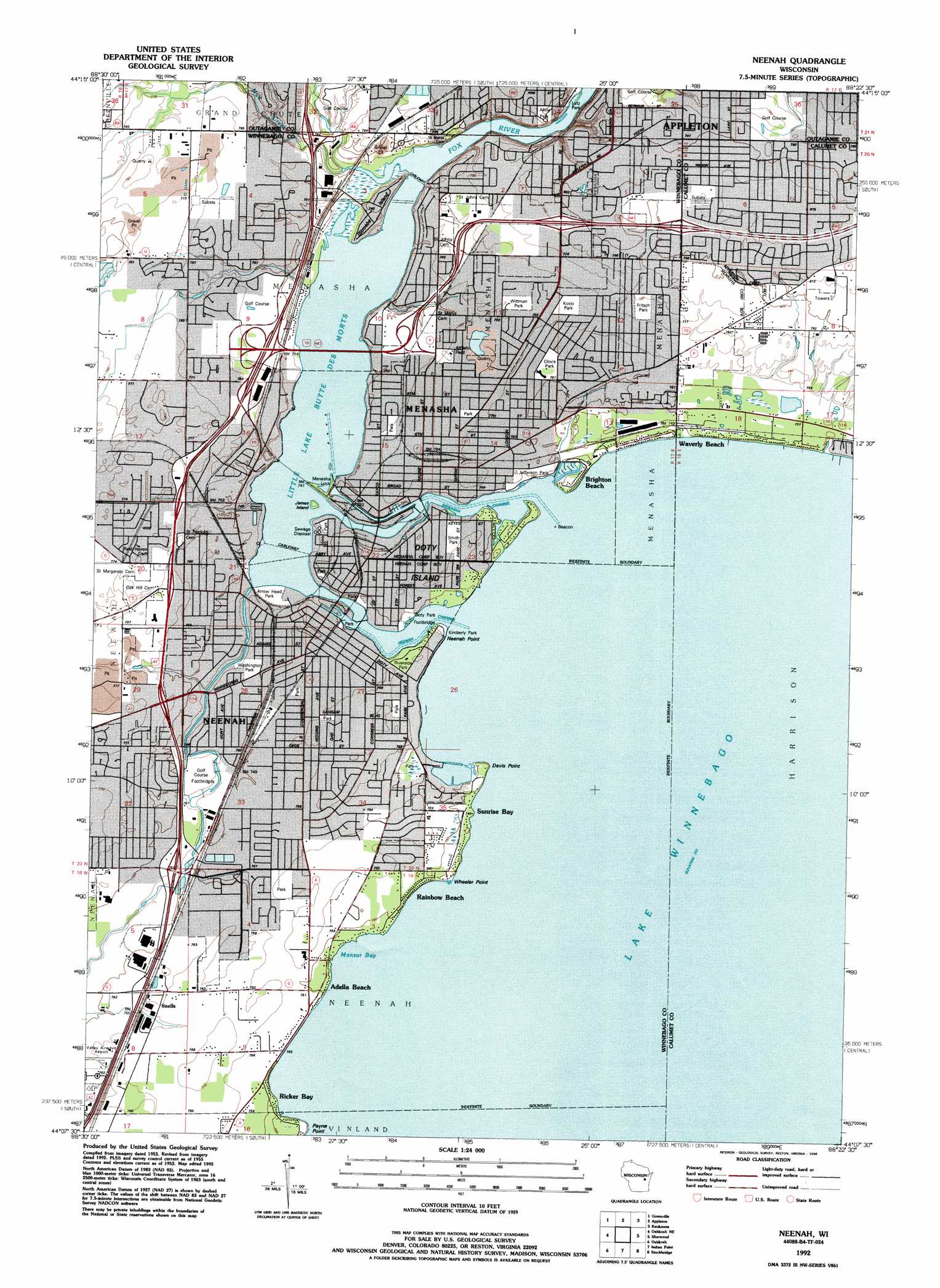
USGS Topo Quad 44088b4 - 1:24,000 scale
| Topo Map Name: | Neenah |
| USGS Topo Quad ID: | 44088b4 |
| Print Size: | ca. 21 1/4" wide x 27" high |
| Southeast Coordinates: | 44.125° N latitude / 88.375° W longitude |
| Map Center Coordinates: | 44.1875° N latitude / 88.4375° W longitude |
| U.S. State: | WI |
| Filename: | o44088b4.jpg |
| Download Map JPG Image: | Neenah topo map 1:24,000 scale |
| Map Type: | Topographic |
| Topo Series: | 7.5´ |
| Map Scale: | 1:24,000 |
| Source of Map Images: | United States Geological Survey (USGS) |
| Alternate Map Versions: |
Neenah WI 1955, updated 1957 Download PDF Buy paper map Neenah WI 1955, updated 1976 Download PDF Buy paper map Neenah WI 1955, updated 1984 Download PDF Buy paper map Neenah WI 1992, updated 1996 Download PDF Buy paper map Neenah WI 2010 Download PDF Buy paper map Neenah WI 2013 Download PDF Buy paper map Neenah WI 2016 Download PDF Buy paper map |
1:24,000 Topo Quads surrounding Neenah
New London |
Shiocton |
Black Creek |
Freedom |
Oneida South |
Hortonville |
Greenville |
Appleton |
Kaukauna |
Wrightstown |
Oshkosh Nw |
Oshkosh Ne |
Neenah |
Sherwood |
Hilbert |
Omro |
Oshkosh |
Indian Point |
Stockbridge |
Chilton |
Pickett |
Van Dyne |
Fahrney Point |
Brothertown |
Marytown |
> Back to 44088a1 at 1:100,000 scale
> Back to 44088a1 at 1:250,000 scale
> Back to U.S. Topo Maps home
Neenah topo map: Gazetteer
Neenah: Airports
Theda Clark Regional Medical Center Heliport elevation 229m 751′Wilmer M Zimmerman Civil Air Patrol Airport elevation 232m 761′
Neenah: Bars
Haystack Reef elevation 228m 748′Lighthouse Reef elevation 228m 748′
Mansur Reef elevation 228m 748′
Outer Bar elevation 228m 748′
Stevens Reef elevation 228m 748′
Neenah: Bays
Mansur Bay elevation 228m 748′Neenah: Capes
Davis Point elevation 229m 751′Neenah Point elevation 229m 751′
Payne Point elevation 229m 751′
Wheeler Point elevation 229m 751′
Neenah: Channels
Menasha Channel elevation 228m 748′Neenah Channel elevation 228m 748′
Neenah: Crossings
Interchange 129 elevation 225m 738′Interchange 131 elevation 232m 761′
Interchange 132 elevation 234m 767′
Interchange 133 elevation 234m 767′
Interchange 134 elevation 230m 754′
Interchange 136 elevation 232m 761′
Neenah: Dams
Menasha Genlaws Dam elevation 228m 748′Menasha Lock elevation 226m 741′
Neenah Dam elevation 225m 738′
Neenah: Islands
Doty Island elevation 230m 754′James Island elevation 226m 741′
Stroebe Island elevation 229m 751′
Neenah: Lakes
Little Lake Butte Des Morts elevation 225m 738′Neenah: Parks
Alicia Park elevation 244m 800′Arrow Head Park elevation 225m 738′
Clovis Park elevation 230m 754′
Columbia Park elevation 230m 754′
Doty Park elevation 228m 748′
Jefferson Park elevation 229m 751′
Kimberly Park elevation 229m 751′
Lutz Park elevation 229m 751′
Riverside Park elevation 230m 754′
Shattuck Park elevation 229m 751′
Smith Park elevation 230m 754′
Washington Park elevation 226m 741′
Neenah: Populated Places
Adella Beach elevation 229m 751′Brighton Beach elevation 229m 751′
Menasha elevation 230m 754′
Neenah elevation 229m 751′
Rainbow Beach elevation 229m 751′
Ricker Bay elevation 229m 751′
Snells elevation 231m 757′
Sunrise Bay elevation 229m 751′
Waverly Beach elevation 229m 751′
Neenah: Post Offices
Menasha Post Office elevation 230m 754′Neenah Post Office elevation 229m 751′
Neenah: Reservoirs
Lake Winnebago 6124 elevation 225m 738′Lake Winnebago 6124 elevation 228m 748′
Neenah: Streams
Mud Creek elevation 225m 738′Neenah digital topo map on disk
Buy this Neenah topo map showing relief, roads, GPS coordinates and other geographical features, as a high-resolution digital map file on DVD: