Menomonie North Topo Map Wisconsin
To zoom in, hover over the map of Menomonie North
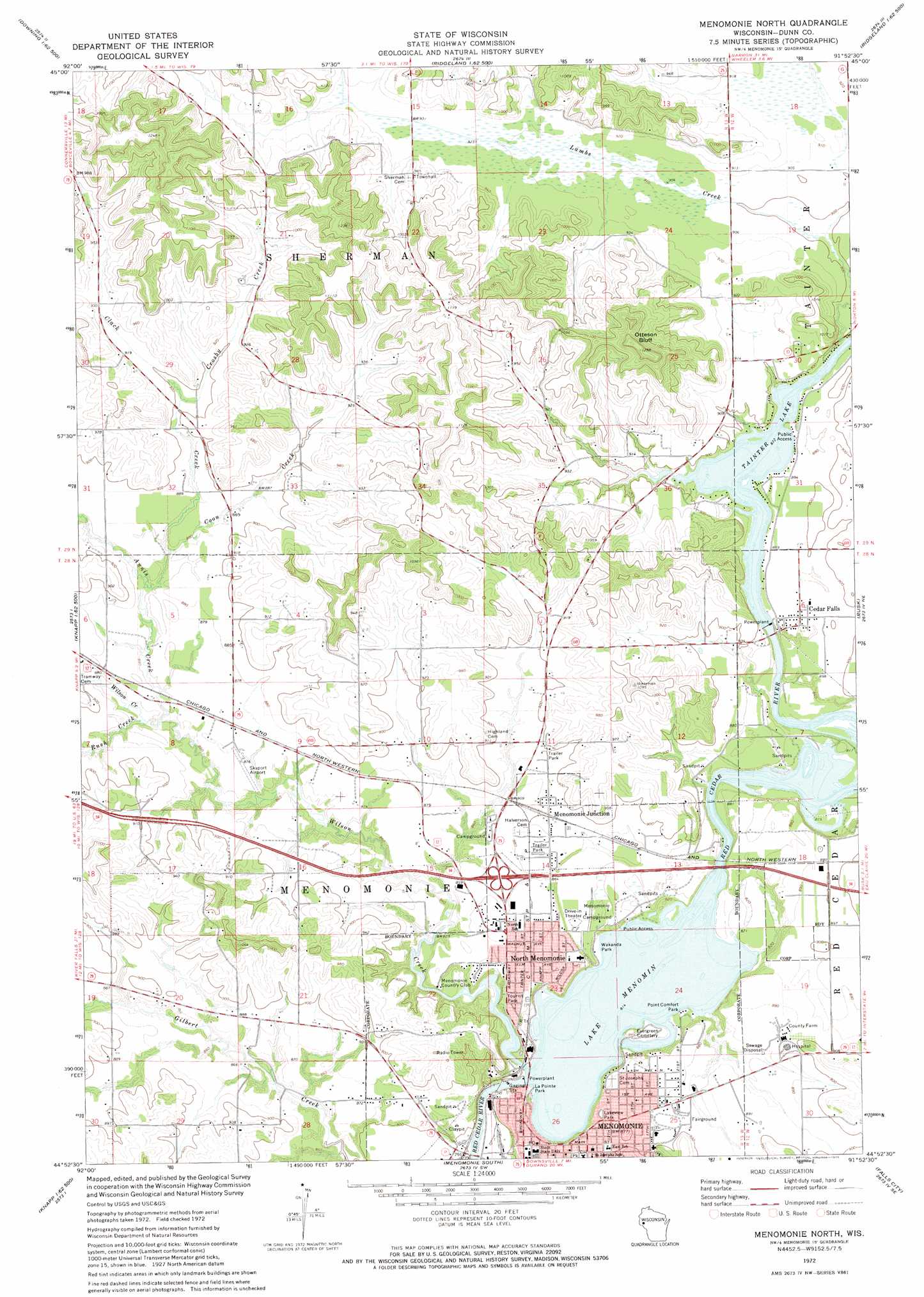
USGS Topo Quad 44091h8 - 1:24,000 scale
| Topo Map Name: | Menomonie North |
| USGS Topo Quad ID: | 44091h8 |
| Print Size: | ca. 21 1/4" wide x 27" high |
| Southeast Coordinates: | 44.875° N latitude / 91.875° W longitude |
| Map Center Coordinates: | 44.9375° N latitude / 91.9375° W longitude |
| U.S. State: | WI |
| Filename: | o44091h8.jpg |
| Download Map JPG Image: | Menomonie North topo map 1:24,000 scale |
| Map Type: | Topographic |
| Topo Series: | 7.5´ |
| Map Scale: | 1:24,000 |
| Source of Map Images: | United States Geological Survey (USGS) |
| Alternate Map Versions: |
Menomonie North WI 1972, updated 1975 Download PDF Buy paper map Menomonie North WI 2010 Download PDF Buy paper map Menomonie North WI 2013 Download PDF Buy paper map Menomonie North WI 2015 Download PDF Buy paper map |
1:24,000 Topo Quads surrounding Menomonie North
Graytown |
Connorsville |
Ridgeland |
Ridgeland Ne |
Sand Creek |
Glenwood City |
Boyceville |
Wheeler |
Norton |
Colfax North |
Wilson |
Knapp |
Menomonie North |
Rusk |
Colfax South |
Spring Valley |
Weston |
Menomonie South |
Falls City |
Elk Creek Lake |
Plum City |
Arkansaw |
Durand North |
Meridean |
Rock Falls |
> Back to 44091e1 at 1:100,000 scale
> Back to 44090a1 at 1:250,000 scale
> Back to U.S. Topo Maps home
Menomonie North topo map: Gazetteer
Menomonie North: Airports
Myrtle Werth Medical Center Heliport elevation 266m 872′Skyport Airport elevation 264m 866′
Menomonie North: Dams
Cedar Falls 1883C3 Dam elevation 259m 849′Menomonie 2WP983 Dam elevation 248m 813′
Menomonie North: Parks
Dunn County Fairgrounds elevation 271m 889′La Pointe Park elevation 248m 813′
Lakeside Park elevation 248m 813′
Lakeview Park elevation 266m 872′
Menomin Park elevation 259m 849′
Menomonie Downtown Historic District elevation 267m 875′
Point Comfort Park elevation 252m 826′
Sanna Park elevation 266m 872′
Wakanda Park elevation 246m 807′
Wilson Park elevation 267m 875′
Menomonie North: Populated Places
Cedar Falls elevation 268m 879′Huber Mobile Home Park elevation 269m 882′
Menominee elevation 271m 889′
Menomonie Junction elevation 269m 882′
North Menomonie elevation 267m 875′
Menomonie North: Post Offices
Menomonie Post Office elevation 266m 872′Menomonie North: Reservoirs
Lake Menomin elevation 248m 813′Tainter Lake elevation 266m 872′
Tainter Lake 1667 elevation 259m 849′
Menomonie North: Streams
Annis Creek elevation 256m 839′Clack Creek elevation 261m 856′
Coon Creek elevation 262m 859′
Crosby Creek elevation 273m 895′
Lambs Creek elevation 266m 872′
Little Lambs Creek elevation 274m 898′
Rush Creek elevation 257m 843′
Wilson Creek elevation 249m 816′
Menomonie North: Summits
Otteson Bluff elevation 383m 1256′Menomonie North digital topo map on disk
Buy this Menomonie North topo map showing relief, roads, GPS coordinates and other geographical features, as a high-resolution digital map file on DVD: