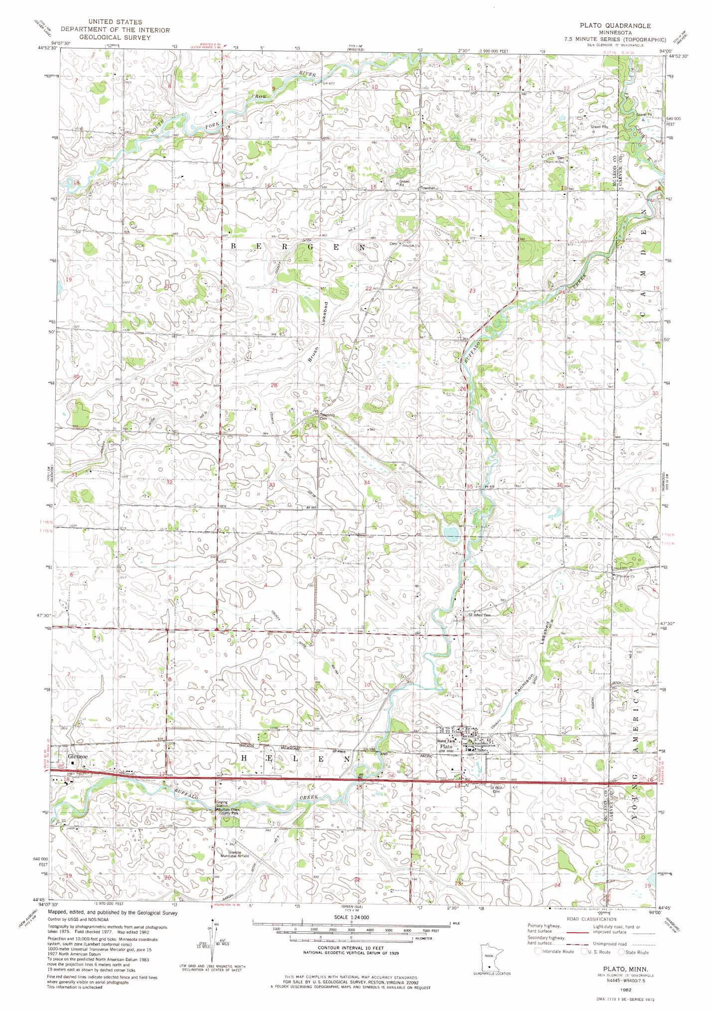
Plato Topo Map Minnesota
To zoom in, hover over the map of Plato
USGS Topo Quad 44094g1 - 1:24,000 scale
| Topo Map Name: | Plato |
| USGS Topo Quad ID: | 44094g1 |
| Print Size: | ca. 21 1/4" wide x 27" high |
| Southeast Coordinates: | 44.75° N latitude / 94° W longitude |
| Map Center Coordinates: | 44.8125° N latitude / 94.0625° W longitude |
| U.S. State: | MN |
| Filename: | o44094g1.jpg |
| Download Map JPG Image: | Plato topo map 1:24,000 scale |
| Map Type: | Topographic |
| Topo Series: | 7.5´ |
| Map Scale: | 1:24,000 |
| Source of Map Images: | United States Geological Survey (USGS) |
| Alternate Map Versions: |
Plato MN 1982, updated 1982 Download PDF Buy paper map Plato MN 2010 Download PDF Buy paper map Plato MN 2013 Download PDF Buy paper map Plato MN 2016 Download PDF Buy paper map |
1:24,000 Topo Quads surrounding Plato
Dassel |
Cokato |
Howard Lake |
Waverly |
Delano |
Hutchinson East |
Silver Lake |
Winsted |
Mayer |
Watertown |
Biscay |
Glenco |
Plato |
Norwood |
Waconia |
Brownton |
New Auburn |
Green Isle |
Hamburg |
Belle Plaine North |
Winthrop |
Gaylord |
Arlington |
Henderson |
Belle Plaine South |
> Back to 44094e1 at 1:100,000 scale
> Back to 44094a1 at 1:250,000 scale
> Back to U.S. Topo Maps home
Plato topo map: Gazetteer
Plato: Airports
Glencoe Municipal Airfield elevation 301m 987′Plato: Canals
County Ditch Number Fifteen A elevation 304m 997′County Ditch Number Five elevation 294m 964′
County Ditch Number Thirteen elevation 300m 984′
County Ditch Number Twentyeight elevation 296m 971′
County Ditch Number Twentynine elevation 301m 987′
Judicial Ditch Number Eight elevation 300m 984′
Plato: Flats
Brush Lakebed elevation 296m 971′Kennison Lakebed elevation 296m 971′
Plato: Parks
Buffalo Creek County Park elevation 296m 971′Plato Baseball Field elevation 303m 994′
Plato: Populated Places
Plato elevation 304m 997′Plato: Post Offices
Plato Post Office elevation 303m 994′Plato: Streams
Crane Creek elevation 290m 951′Silver Creek elevation 290m 951′
Plato digital topo map on disk
Buy this Plato topo map showing relief, roads, GPS coordinates and other geographical features, as a high-resolution digital map file on DVD: