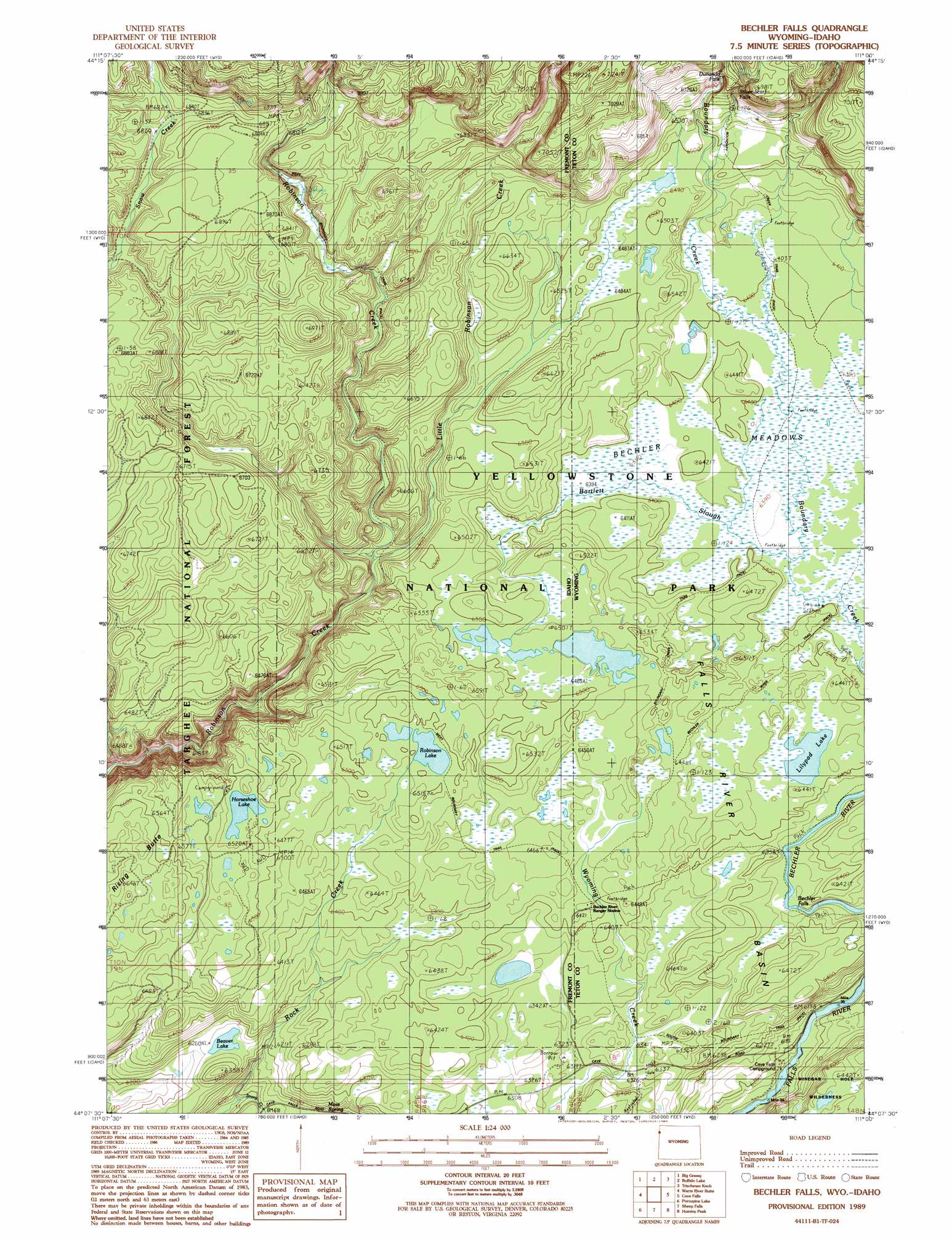
Bechler Falls Topo Map Idaho
To zoom in, hover over the map of Bechler Falls
USGS Topo Quad 44111b1 - 1:24,000 scale
| Topo Map Name: | Bechler Falls |
| USGS Topo Quad ID: | 44111b1 |
| Print Size: | ca. 21 1/4" wide x 27" high |
| Southeast Coordinates: | 44.125° N latitude / 111° W longitude |
| Map Center Coordinates: | 44.1875° N latitude / 111.0625° W longitude |
| U.S. States: | ID, WY |
| Filename: | o44111b1.jpg |
| Download Map JPG Image: | Bechler Falls topo map 1:24,000 scale |
| Map Type: | Topographic |
| Topo Series: | 7.5´ |
| Map Scale: | 1:24,000 |
| Source of Map Images: | United States Geological Survey (USGS) |
| Alternate Map Versions: |
Bechler Falls WY 1989, updated 1989 Download PDF Buy paper map Bechler Falls WY 1989, updated 1989 Download PDF Buy paper map Bechler Falls WY 2011 Download PDF Buy paper map Bechler Falls WY 2015 Download PDF Buy paper map |
| FStopo: | US Forest Service topo Bechler Falls is available: Download FStopo PDF Download FStopo TIF |
1:24,000 Topo Quads surrounding Bechler Falls
Island Park |
Latham Spring |
Buffalo Lake Ne |
Summit Lake |
Old Faithful |
Hatchery Butte |
Big Grassy |
Buffalo Lake |
Trischman Knob |
Shoshone Geyser Basin |
Snake River Butte |
Warm River Butte |
Bechler Falls |
Cave Falls |
Grassy Lake Reservoir |
Warm River |
Porcupine Lake |
Sheep Falls |
Hominy Peak |
Survey Peak |
Drummond |
Lamont |
Mcrenolds Reservoir |
Rammel Mountain |
Ranger Peak |
> Back to 44111a1 at 1:100,000 scale
> Back to 44110a1 at 1:250,000 scale
> Back to U.S. Topo Maps home
Bechler Falls topo map: Gazetteer
Bechler Falls: Falls
Bechler Falls elevation 1933m 6341′Dunanda Falls elevation 2007m 6584′
Silver Scarf Falls elevation 2021m 6630′
Bechler Falls: Flats
Bechler Meadows elevation 1949m 6394′Bechler Falls: Lakes
Beaver Lake elevation 1905m 6250′Horseshoe Lake elevation 1984m 6509′
Lilypad Lake elevation 1954m 6410′
Robinson Lake elevation 1978m 6489′
Bechler Falls: Springs
Boundary Creek Hot Springs elevation 1999m 6558′Moss Spring elevation 1900m 6233′
Bechler Falls: Streams
Bartlett Slough elevation 1948m 6391′Bartlett Slough elevation 1949m 6394′
Boundary Creek elevation 1950m 6397′
Boundary Creek elevation 1950m 6397′
Little Robinson Creek elevation 1933m 6341′
Bechler Falls: Trails
Boundary Creek Trail elevation 1949m 6394′West Boundary Trail elevation 1942m 6371′
Bechler Falls digital topo map on disk
Buy this Bechler Falls topo map showing relief, roads, GPS coordinates and other geographical features, as a high-resolution digital map file on DVD: