Warbonnet Peak Topo Map Idaho
To zoom in, hover over the map of Warbonnet Peak
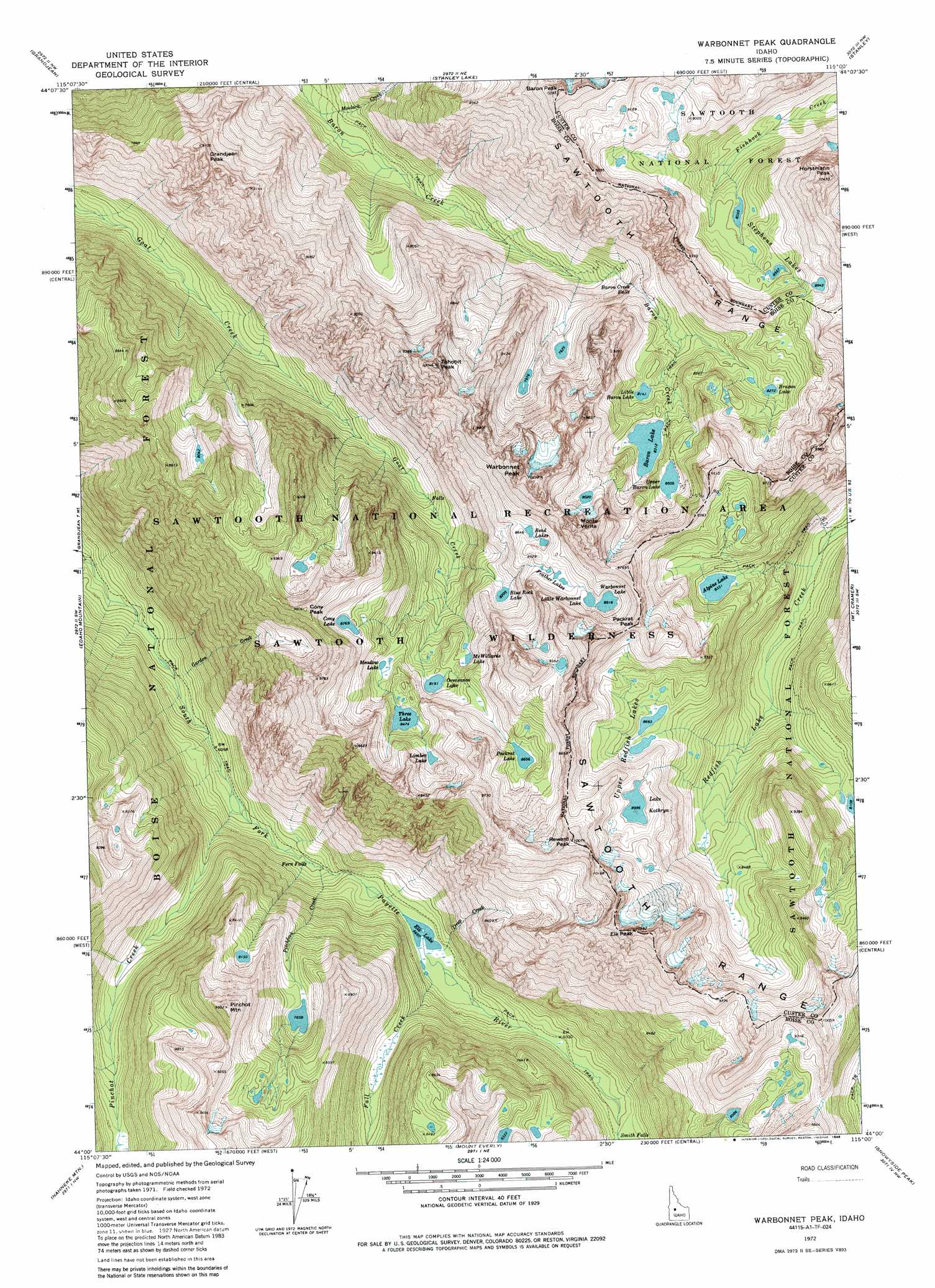
USGS Topo Quad 44115a1 - 1:24,000 scale
| Topo Map Name: | Warbonnet Peak |
| USGS Topo Quad ID: | 44115a1 |
| Print Size: | ca. 21 1/4" wide x 27" high |
| Southeast Coordinates: | 44° N latitude / 115° W longitude |
| Map Center Coordinates: | 44.0625° N latitude / 115.0625° W longitude |
| U.S. State: | ID |
| Filename: | o44115a1.jpg |
| Download Map JPG Image: | Warbonnet Peak topo map 1:24,000 scale |
| Map Type: | Topographic |
| Topo Series: | 7.5´ |
| Map Scale: | 1:24,000 |
| Source of Map Images: | United States Geological Survey (USGS) |
| Alternate Map Versions: |
Warbonnet Peak ID 1972, updated 1977 Download PDF Buy paper map Warbonnet Peak ID 1972, updated 1980 Download PDF Buy paper map Warbonnet Peak ID 1972, updated 1986 Download PDF Buy paper map Warbonnet Peak ID 2011 Download PDF Buy paper map Warbonnet Peak ID 2013 Download PDF Buy paper map |
| FStopo: | US Forest Service topo Warbonnet Peak is available: Download FStopo PDF Download FStopo TIF |
1:24,000 Topo Quads surrounding Warbonnet Peak
Bull Trout Point |
Banner Summit |
Elk Meadow |
Basin Butte |
East Basin Creek |
Eightmile Mountain |
Grandjean |
Stanley Lake |
Stanley |
Casino Lakes |
Tyee Mountain |
Edaho Mountain |
Warbonnet Peak |
Mount Cramer |
Obsidian |
Swanholm Peak |
Nahneke Mountain |
Mount Everly |
Snowyside Peak |
Alturas Lake |
Phifer Creek |
Atlanta West |
Atlanta East |
Marshall Peak |
Frenchman Creek |
> Back to 44115a1 at 1:100,000 scale
> Back to 44114a1 at 1:250,000 scale
> Back to U.S. Topo Maps home
Warbonnet Peak topo map: Gazetteer
Warbonnet Peak: Falls
Baron Creek Falls elevation 2312m 7585′Fern Falls elevation 1953m 6407′
Smith Falls elevation 2151m 7057′
Warbonnet Peak: Lakes
Alpine Lake elevation 2434m 7985′Baron Lakes elevation 2535m 8316′
Bead Lakes elevation 2698m 8851′
Blue Rock Lake elevation 2657m 8717′
Braxon Lake elevation 2519m 8264′
Cony Lake elevation 2513m 8244′
Elk Lake elevation 2029m 6656′
Feather Lakes elevation 2558m 8392′
Lake Kathryn elevation 2745m 9005′
Limber Lake elevation 2640m 8661′
Little Baron Lake elevation 2482m 8143′
McWillards Lake elevation 3049m 10003′
Meadow Lake elevation 2852m 9356′
Oreamnos Lake elevation 2902m 9520′
Packrat Lake elevation 2688m 8818′
Stevens Lakes elevation 2169m 7116′
Three Lake elevation 2682m 8799′
Upper Redfish Lakes elevation 2561m 8402′
Warbonnet Lake elevation 2616m 8582′
Warbonnet Peak: Streams
Drop Creek elevation 2030m 6660′Fall Creek elevation 2028m 6653′
Garden Creek elevation 2886m 9468′
Moolack Creek elevation 1858m 6095′
Pinchot Creek elevation 1872m 6141′
Pitchfork Creek elevation 1951m 6400′
Warbonnet Peak: Summits
Baron Peak elevation 3072m 10078′Cony Peak elevation 2349m 7706′
Elk Peak elevation 3222m 10570′
Grandjean Peak elevation 2762m 9061′
Horstmann Peak elevation 3116m 10223′
Monte Verita elevation 2772m 9094′
Packrat Peak elevation 2952m 9685′
Pinchot Mountain elevation 2881m 9452′
Reward Peak elevation 2818m 9245′
Tohobit Peak elevation 2509m 8231′
Warbonnet Peak elevation 3093m 10147′
Warbonnet Peak digital topo map on disk
Buy this Warbonnet Peak topo map showing relief, roads, GPS coordinates and other geographical features, as a high-resolution digital map file on DVD: