Angell Butte Topo Map Oregon
To zoom in, hover over the map of Angell Butte
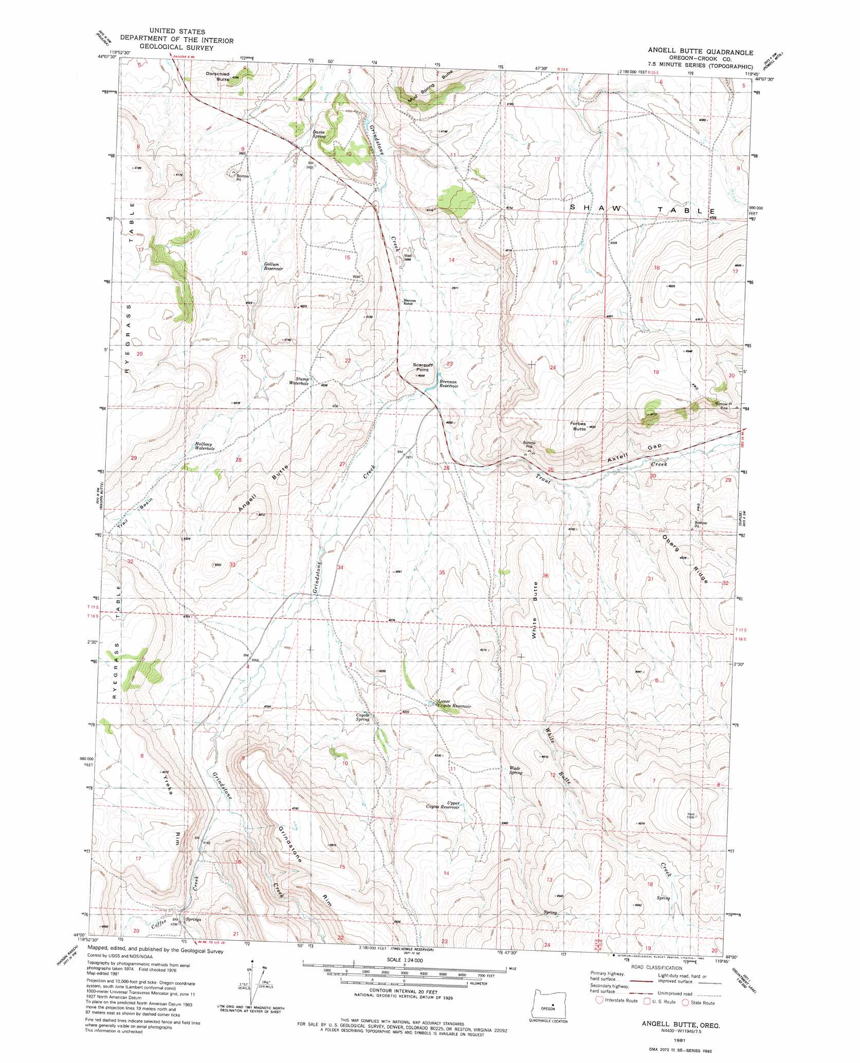
USGS Topo Quad 44119a7 - 1:24,000 scale
| Topo Map Name: | Angell Butte |
| USGS Topo Quad ID: | 44119a7 |
| Print Size: | ca. 21 1/4" wide x 27" high |
| Southeast Coordinates: | 44° N latitude / 119.75° W longitude |
| Map Center Coordinates: | 44.0625° N latitude / 119.8125° W longitude |
| U.S. State: | OR |
| Filename: | o44119a7.jpg |
| Download Map JPG Image: | Angell Butte topo map 1:24,000 scale |
| Map Type: | Topographic |
| Topo Series: | 7.5´ |
| Map Scale: | 1:24,000 |
| Source of Map Images: | United States Geological Survey (USGS) |
| Alternate Map Versions: |
Angell Butte OR 1981, updated 1982 Download PDF Buy paper map Angell Butte OR 2011 Download PDF Buy paper map Angell Butte OR 2014 Download PDF Buy paper map |
1:24,000 Topo Quads surrounding Angell Butte
Keys Creek |
Little Summit Prairie |
Six Corners |
Wolf Mountain |
Aldrich Gulch |
Rabbit Valley |
Paulina |
Mud Spring |
Powell Mountain |
Suplee Butte |
Liggett Table |
Maupin Butte |
Angell Butte |
Suplee |
Funny Butte |
Sand Hollow |
Hardin Ranch |
Twelvemile Reservoir |
Delintment Lake |
Big Mowich Mountain |
G. I. Ranch |
Ibex Butte |
Mackey Butte |
Buck Spring |
Donnelly Butte |
> Back to 44119a1 at 1:100,000 scale
> Back to 44118a1 at 1:250,000 scale
> Back to U.S. Topo Maps home
Angell Butte topo map: Gazetteer
Angell Butte: Basins
Trail Basin elevation 1241m 4071′Angell Butte: Cliffs
Grindstone Rim elevation 1450m 4757′Yreka Rim elevation 1383m 4537′
Angell Butte: Dams
Brennan Dam elevation 1204m 3950′Layton Dam Number 2 elevation 1184m 3884′
Angell Butte: Gaps
Axtell Gap elevation 1276m 4186′Angell Butte: Post Offices
Hardin Post Office (historical) elevation 1217m 3992′Angell Butte: Reservoirs
Brennan Reservoir elevation 1204m 3950′Gollum Reservoir elevation 1206m 3956′
Halfway Waterhole elevation 1233m 4045′
Layton Reservoir Number 2 elevation 1184m 3884′
Lower Coyote Reservoir elevation 1276m 4186′
Stump Waterhole elevation 1226m 4022′
Upper Coyote Reservoir elevation 1327m 4353′
Angell Butte: Ridges
Oberg Ridge elevation 1382m 4534′Angell Butte: Springs
Coyote Spring elevation 1254m 4114′Davin Spring elevation 1187m 3894′
Wade Spring elevation 1327m 4353′
Angell Butte: Streams
Coffee Creek elevation 1258m 4127′South Fork Trout Creek elevation 1213m 3979′
Trout Creek elevation 1204m 3950′
White Butte Creek elevation 1233m 4045′
Angell Butte: Summits
Angell Butte elevation 1343m 4406′Dorschied Butte elevation 1249m 4097′
Forbes Butte elevation 1412m 4632′
Ryegrass Table elevation 1317m 4320′
Scareoff Point elevation 1236m 4055′
Shaw Table elevation 1421m 4662′
Angell Butte digital topo map on disk
Buy this Angell Butte topo map showing relief, roads, GPS coordinates and other geographical features, as a high-resolution digital map file on DVD: