Paulina Topo Map Oregon
To zoom in, hover over the map of Paulina
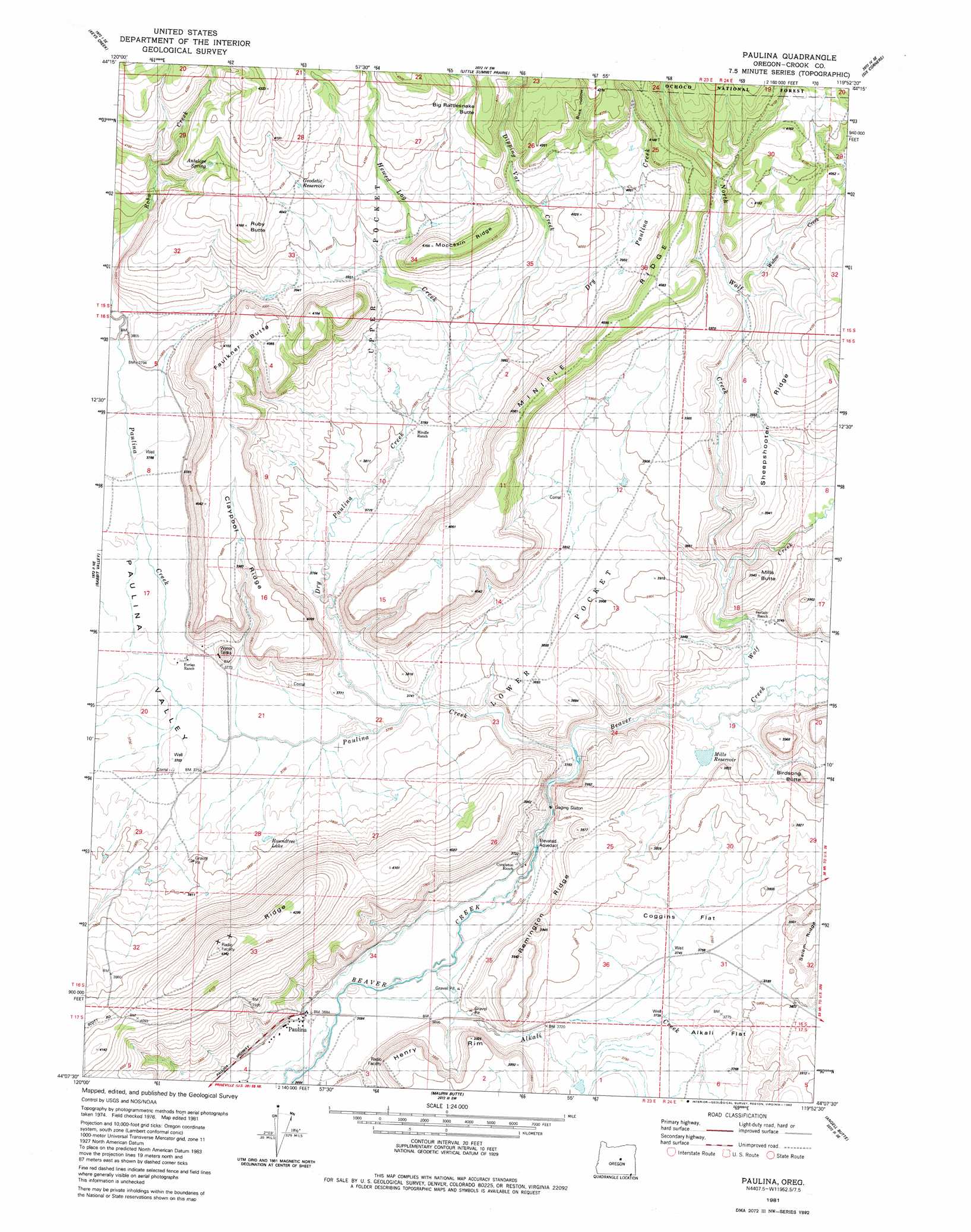
USGS Topo Quad 44119b8 - 1:24,000 scale
| Topo Map Name: | Paulina |
| USGS Topo Quad ID: | 44119b8 |
| Print Size: | ca. 21 1/4" wide x 27" high |
| Southeast Coordinates: | 44.125° N latitude / 119.875° W longitude |
| Map Center Coordinates: | 44.1875° N latitude / 119.9375° W longitude |
| U.S. State: | OR |
| Filename: | o44119b8.jpg |
| Download Map JPG Image: | Paulina topo map 1:24,000 scale |
| Map Type: | Topographic |
| Topo Series: | 7.5´ |
| Map Scale: | 1:24,000 |
| Source of Map Images: | United States Geological Survey (USGS) |
| Alternate Map Versions: |
Paulina OR 1981, updated 1982 Download PDF Buy paper map Paulina OR 1992, updated 1997 Download PDF Buy paper map Paulina OR 2011 Download PDF Buy paper map Paulina OR 2014 Download PDF Buy paper map |
| FStopo: | US Forest Service topo Paulina is available: Download FStopo PDF Download FStopo TIF |
1:24,000 Topo Quads surrounding Paulina
Mount Pisgah |
Peterson Point |
Derr Meadows |
Antone |
Day Basin |
Williams Prairie |
Keys Creek |
Little Summit Prairie |
Six Corners |
Wolf Mountain |
Committee Creek |
Rabbit Valley |
Paulina |
Mud Spring |
Powell Mountain |
Arrowwood Point |
Liggett Table |
Maupin Butte |
Angell Butte |
Suplee |
Gerry Mountain |
Sand Hollow |
Hardin Ranch |
Twelvemile Reservoir |
Delintment Lake |
> Back to 44119a1 at 1:100,000 scale
> Back to 44118a1 at 1:250,000 scale
> Back to U.S. Topo Maps home
Paulina topo map: Gazetteer
Paulina: Basins
Lower Pocket elevation 1177m 3861′Upper Pocket elevation 1206m 3956′
Paulina: Cliffs
Henry Rim elevation 1190m 3904′Paulina: Flats
Coggins Flat elevation 1144m 3753′Paulina: Populated Places
Paulina elevation 1124m 3687′Paulina: Post Offices
Paulina Post Office elevation 1124m 3687′Paulina: Reservoirs
Geodetic Reservoir elevation 1242m 4074′Mills Reservoir elevation 1141m 3743′
Ritch-Fayne Reservoir elevation 1154m 3786′
Roundtree Lake elevation 1152m 3779′
Paulina: Ridges
Claypool Ridge elevation 1144m 3753′Minifie Ridge elevation 1248m 4094′
Moccasin Ridge elevation 1263m 4143′
Remington Ridge elevation 1202m 3943′
Sheepshooter Ridge elevation 1215m 3986′
X X Ridge elevation 1320m 4330′
Paulina: Springs
Antelope Spring elevation 1245m 4084′Paulina: Streams
Alkali Creek elevation 1123m 3684′Dipping Vat Creek elevation 1175m 3854′
Dry Paulina Creek elevation 1148m 3766′
Hewed Log Creek elevation 1162m 3812′
North Wolf Creek elevation 1149m 3769′
Paulina Creek elevation 1135m 3723′
Widow Creek elevation 1188m 3897′
Wolf Creek elevation 1138m 3733′
Paulina: Summits
Big Rattlesnake Butte elevation 1259m 4130′Birdsong Butte elevation 1198m 3930′
Faulkner Butte elevation 1251m 4104′
Mills Butte elevation 1203m 3946′
Ruby Butte elevation 1270m 4166′
Paulina: Valleys
Buck Hollow elevation 1256m 4120′Hewed Log Hollow elevation 1180m 3871′
Paulina Valley elevation 1135m 3723′
Paulina digital topo map on disk
Buy this Paulina topo map showing relief, roads, GPS coordinates and other geographical features, as a high-resolution digital map file on DVD: