Suplee Butte Topo Map Oregon
To zoom in, hover over the map of Suplee Butte
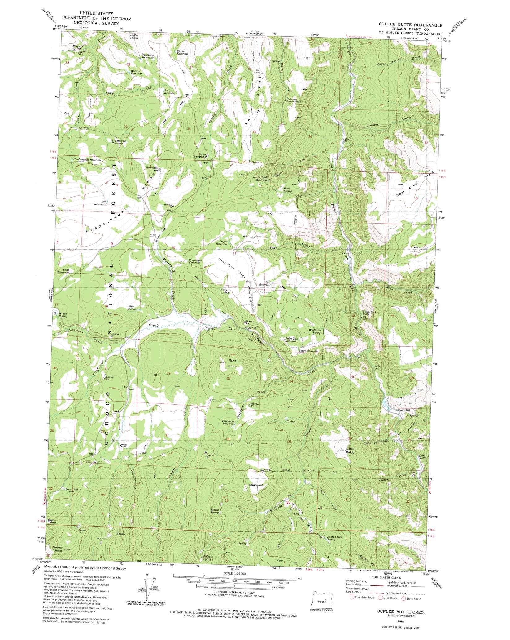
USGS Topo Quad 44119b5 - 1:24,000 scale
| Topo Map Name: | Suplee Butte |
| USGS Topo Quad ID: | 44119b5 |
| Print Size: | ca. 21 1/4" wide x 27" high |
| Southeast Coordinates: | 44.125° N latitude / 119.5° W longitude |
| Map Center Coordinates: | 44.1875° N latitude / 119.5625° W longitude |
| U.S. State: | OR |
| Filename: | o44119b5.jpg |
| Download Map JPG Image: | Suplee Butte topo map 1:24,000 scale |
| Map Type: | Topographic |
| Topo Series: | 7.5´ |
| Map Scale: | 1:24,000 |
| Source of Map Images: | United States Geological Survey (USGS) |
| Alternate Map Versions: |
Suplee Butte OR 1981, updated 1981 Download PDF Buy paper map Suplee Butte OR 1992, updated 1997 Download PDF Buy paper map Suplee Butte OR 2011 Download PDF Buy paper map Suplee Butte OR 2014 Download PDF Buy paper map |
| FStopo: | US Forest Service topo Suplee Butte is available: Download FStopo PDF Download FStopo TIF |
1:24,000 Topo Quads surrounding Suplee Butte
Antone |
Day Basin |
Dayville |
Aldrich Mountain North |
Shop Gulch |
Six Corners |
Wolf Mountain |
Aldrich Gulch |
Aldrich Mountain South |
Big Weasel Sprs |
Mud Spring |
Powell Mountain |
Suplee Butte |
Graylock Butte |
Flagtail Mountain |
Angell Butte |
Suplee |
Funny Butte |
Izee |
Lewis Creek |
Twelvemile Reservoir |
Delintment Lake |
Big Mowich Mountain |
Whiskey Mountain |
Alsup Mountain |
> Back to 44119a1 at 1:100,000 scale
> Back to 44118a1 at 1:250,000 scale
> Back to U.S. Topo Maps home
Suplee Butte topo map: Gazetteer
Suplee Butte: Falls
South Fork Falls elevation 1077m 3533′Suplee Butte: Flats
Cinnabar Flat elevation 1483m 4865′Holding Pasture elevation 1334m 4376′
Murray Flat elevation 1442m 4730′
Suplee Butte: Reservoirs
Art Reservoir elevation 1375m 4511′Big Mowich Reservoir elevation 1365m 4478′
Cayuse Reservoir elevation 1361m 4465′
Coyote Reservoir elevation 1468m 4816′
Davis Creek Reservoir elevation 1355m 4445′
Dual Reservoir elevation 1484m 4868′
Elk Reservoir elevation 1485m 4872′
Fort Reservoir elevation 1442m 4730′
Greenwater Reservoir elevation 1450m 4757′
Hard Scrabble Reservoir elevation 1380m 4527′
Hobnail Reservoir elevation 1333m 4373′
Porcipine Reservoir elevation 1438m 4717′
Sedge Reservoir elevation 1419m 4655′
Sedge Two Reservoir elevation 1435m 4708′
Viewpoint Reservoir elevation 1343m 4406′
Wildhorse Falls Reservoir elevation 1098m 3602′
Wildhorse Reservoir elevation 1440m 4724′
Suplee Butte: Springs
Blue Pot Spring elevation 1277m 4189′Blue Spring elevation 1428m 4685′
Buck Spring elevation 1388m 4553′
Hobble Spring elevation 1303m 4274′
Santa Claus Spring elevation 1474m 4835′
Skid Seep elevation 1434m 4704′
Strip Spring elevation 1430m 4691′
Stump Spring elevation 1536m 5039′
Wildcat Spring elevation 1588m 5209′
Wildhorse Spring elevation 1408m 4619′
Willow Spring elevation 1481m 4858′
Suplee Butte: Streams
Basin Creek elevation 1310m 4297′Cougar Creek elevation 1375m 4511′
Davis Creek elevation 1001m 3284′
Deer Creek elevation 1060m 3477′
Fort Creek elevation 1038m 3405′
Frazier Creek elevation 1145m 3756′
Junction Creek elevation 1175m 3854′
Little Fir Creek elevation 1132m 3713′
Little Frazier Creek elevation 1140m 3740′
Magic Lantern Creek elevation 982m 3221′
Porcipine Creek elevation 1222m 4009′
Santa Claus Stream elevation 1380m 4527′
South Fork Wind Creek elevation 1235m 4051′
Sunflower Creek elevation 1115m 3658′
Trail Creek elevation 1361m 4465′
Wildcat Creek elevation 1168m 3832′
Suplee Butte: Summits
Little Baldy elevation 1548m 5078′Spur Butte elevation 1565m 5134′
Sugarloaf elevation 1619m 5311′
Sugarloaf Mountain elevation 1566m 5137′
Suplee Butte elevation 1758m 5767′
Suplee Butte: Valleys
Cougar Gulch elevation 1021m 3349′Suplee Butte digital topo map on disk
Buy this Suplee Butte topo map showing relief, roads, GPS coordinates and other geographical features, as a high-resolution digital map file on DVD: