Graylock Butte Topo Map Oregon
To zoom in, hover over the map of Graylock Butte
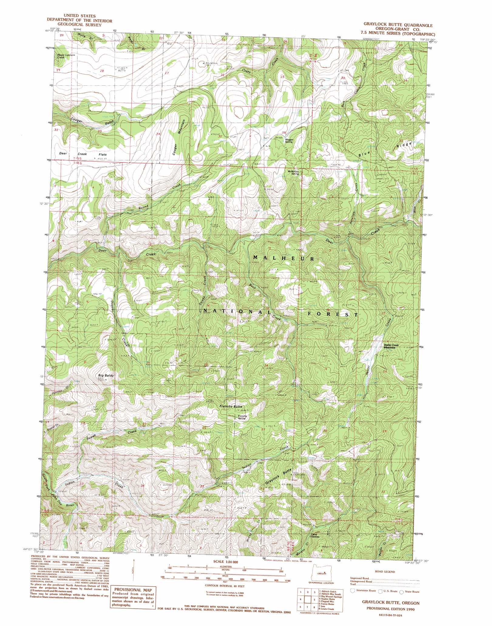
USGS Topo Quad 44119b4 - 1:24,000 scale
| Topo Map Name: | Graylock Butte |
| USGS Topo Quad ID: | 44119b4 |
| Print Size: | ca. 21 1/4" wide x 27" high |
| Southeast Coordinates: | 44.125° N latitude / 119.375° W longitude |
| Map Center Coordinates: | 44.1875° N latitude / 119.4375° W longitude |
| U.S. State: | OR |
| Filename: | o44119b4.jpg |
| Download Map JPG Image: | Graylock Butte topo map 1:24,000 scale |
| Map Type: | Topographic |
| Topo Series: | 7.5´ |
| Map Scale: | 1:24,000 |
| Source of Map Images: | United States Geological Survey (USGS) |
| Alternate Map Versions: |
Graylock Butte OR 1990, updated 1990 Download PDF Buy paper map Graylock Butte OR 1998, updated 2000 Download PDF Buy paper map Graylock Butte OR 2011 Download PDF Buy paper map Graylock Butte OR 2014 Download PDF Buy paper map |
| FStopo: | US Forest Service topo Graylock Butte is available: Download FStopo PDF Download FStopo TIF |
1:24,000 Topo Quads surrounding Graylock Butte
Day Basin |
Dayville |
Aldrich Mountain North |
Shop Gulch |
Wolfinger Butte |
Wolf Mountain |
Aldrich Gulch |
Aldrich Mountain South |
Big Weasel Sprs |
Mcclellan Mountain |
Powell Mountain |
Suplee Butte |
Graylock Butte |
Flagtail Mountain |
Logdell |
Suplee |
Funny Butte |
Izee |
Lewis Creek |
Five Hundred Flat |
Delintment Lake |
Big Mowich Mountain |
Whiskey Mountain |
Alsup Mountain |
West Myrtle Butte |
> Back to 44119a1 at 1:100,000 scale
> Back to 44118a1 at 1:250,000 scale
> Back to U.S. Topo Maps home
Graylock Butte topo map: Gazetteer
Graylock Butte: Flats
Deer Creek Flats elevation 1429m 4688′Vester Creek Meadows elevation 1499m 4917′
Graylock Butte: Reservoirs
Pewee Creek Reservoir elevation 1434m 4704′Graylock Butte: Springs
Frenchy Spring elevation 1702m 5583′Maggot Spring elevation 1414m 4639′
McMullen Spring elevation 1452m 4763′
Softwater Spring elevation 1718m 5636′
Graylock Butte: Streams
Antelope Creek elevation 1343m 4406′Blue Creek elevation 1353m 4438′
Buck Creek elevation 1277m 4189′
Dewey Creek elevation 1256m 4120′
Dry Pine Creek elevation 1184m 3884′
Dugout Creek elevation 1225m 4019′
Indian Creek elevation 1161m 3809′
Pewee Creek elevation 1206m 3956′
Round Creek elevation 1198m 3930′
Vester Creek elevation 1336m 4383′
Graylock Butte: Summits
Big Baldy elevation 1699m 5574′Cougar Mountain elevation 1517m 4977′
Frenchy Butte elevation 1728m 5669′
Graylock Butte elevation 1672m 5485′
Graylock Butte digital topo map on disk
Buy this Graylock Butte topo map showing relief, roads, GPS coordinates and other geographical features, as a high-resolution digital map file on DVD: