Cline Falls Topo Map Oregon
To zoom in, hover over the map of Cline Falls
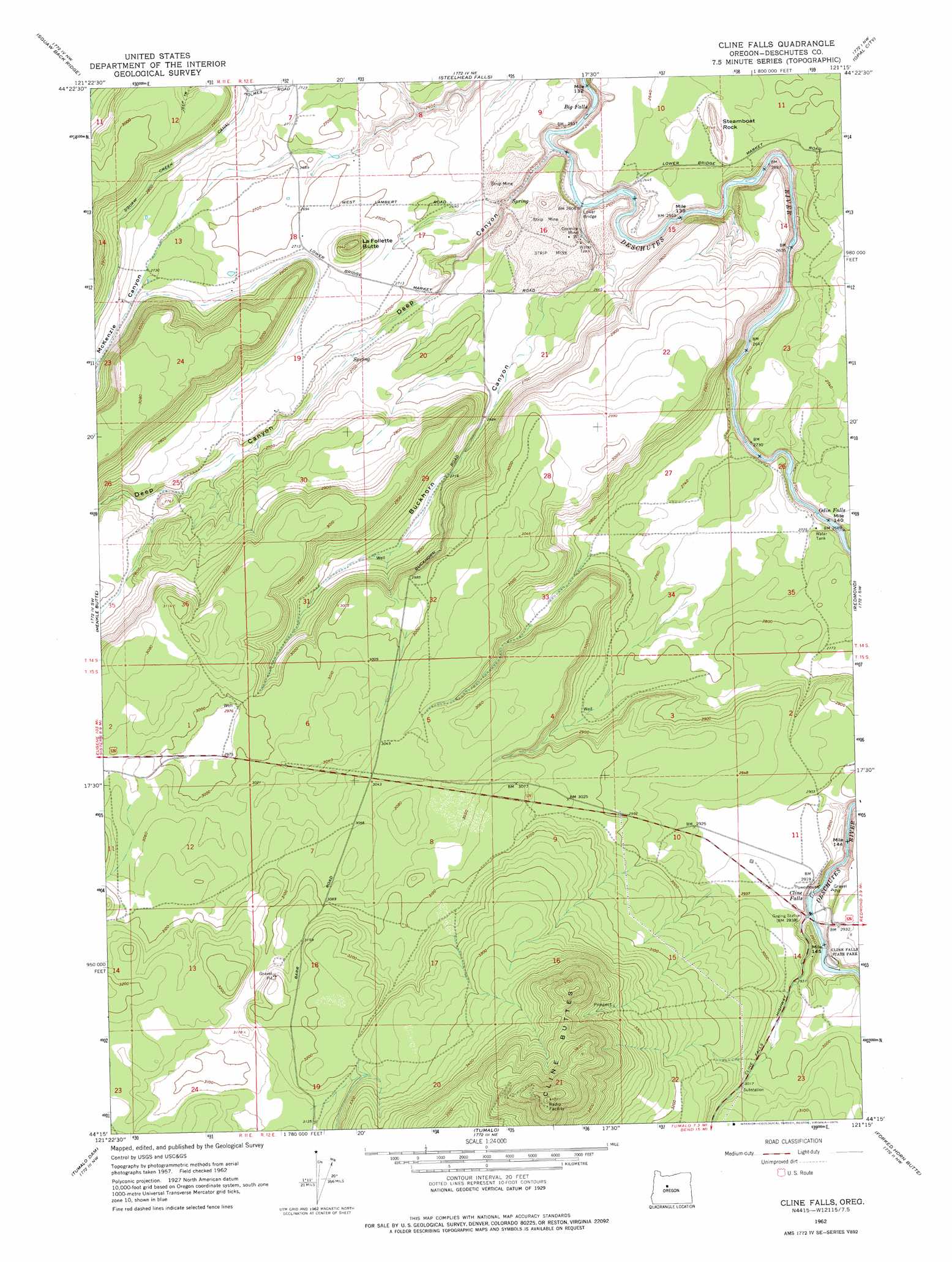
USGS Topo Quad 44121c3 - 1:24,000 scale
| Topo Map Name: | Cline Falls |
| USGS Topo Quad ID: | 44121c3 |
| Print Size: | ca. 21 1/4" wide x 27" high |
| Southeast Coordinates: | 44.25° N latitude / 121.25° W longitude |
| Map Center Coordinates: | 44.3125° N latitude / 121.3125° W longitude |
| U.S. State: | OR |
| Filename: | o44121c3.jpg |
| Download Map JPG Image: | Cline Falls topo map 1:24,000 scale |
| Map Type: | Topographic |
| Topo Series: | 7.5´ |
| Map Scale: | 1:24,000 |
| Source of Map Images: | United States Geological Survey (USGS) |
| Alternate Map Versions: |
Cline Falls OR 1962, updated 1963 Download PDF Buy paper map Cline Falls OR 1962, updated 1975 Download PDF Buy paper map Cline Falls OR 1962, updated 1975 Download PDF Buy paper map Cline Falls OR 2011 Download PDF Buy paper map Cline Falls OR 2014 Download PDF Buy paper map |
1:24,000 Topo Quads surrounding Cline Falls
Prairie Farm Spring |
Fly Creek |
Round Butte Dam |
Culver |
Buck Butte |
Little Squaw Back |
Squaw Back Ridge |
Steelhead Falls |
Opal City |
Gray Butte |
Sisters |
Henkle Butte |
Cline Falls |
Redmond |
O'Neil |
Three Creek Butte |
Tumalo Dam |
Tumalo |
Forked Horn Butte |
Powell Butte |
Tumalo Falls |
Shevlin Park |
Bend |
Bend Airport |
Alfalfa |
> Back to 44121a1 at 1:100,000 scale
> Back to 44120a1 at 1:250,000 scale
> Back to U.S. Topo Maps home
Cline Falls topo map: Gazetteer
Cline Falls: Airports
Cline Falls Air Park elevation 890m 2919′Cline Falls: Dams
Deep Canyon Dam elevation 802m 2631′Cline Falls: Falls
Big Falls elevation 765m 2509′Cline Falls elevation 853m 2798′
Odin Falls elevation 815m 2673′
Cline Falls: Mines
Diatomite Mine Headquarters elevation 771m 2529′Oremite Mine elevation 785m 2575′
Cline Falls: Parks
Cline Falls State Park elevation 874m 2867′Cline Falls: Populated Places
Cline Falls (historical) elevation 867m 2844′Lower Bridge (historical) elevation 772m 2532′
Cline Falls: Post Offices
Cline Falls Post Office (historical) elevation 891m 2923′Lower Bridge Post Office (historical) elevation 774m 2539′
Cline Falls: Reservoirs
Deep Canyon Reservoir elevation 802m 2631′Cline Falls: Ridges
Steamboat Rock elevation 823m 2700′Cline Falls: Summits
Bessie Butte elevation 817m 2680′Cline Buttes elevation 1255m 4117′
LaFollette Butte elevation 893m 2929′
Cline Falls: Valleys
Buckhorn Canyon elevation 775m 2542′Deep Canyon elevation 774m 2539′
McKenzie Canyon elevation 830m 2723′
Cline Falls digital topo map on disk
Buy this Cline Falls topo map showing relief, roads, GPS coordinates and other geographical features, as a high-resolution digital map file on DVD: