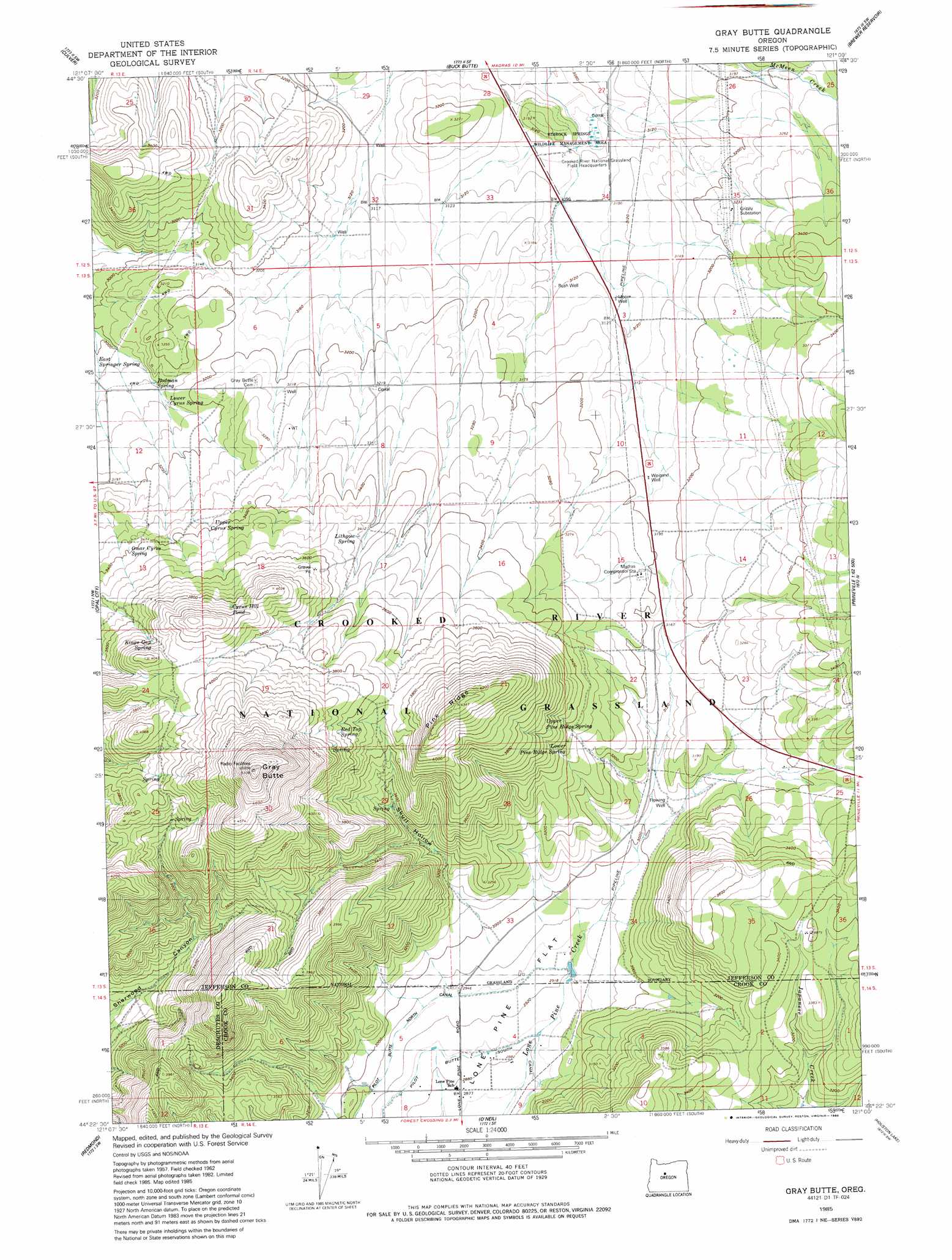
Gray Butte Topo Map Oregon
To zoom in, hover over the map of Gray Butte
USGS Topo Quad 44121d1 - 1:24,000 scale
| Topo Map Name: | Gray Butte |
| USGS Topo Quad ID: | 44121d1 |
| Print Size: | ca. 21 1/4" wide x 27" high |
| Southeast Coordinates: | 44.375° N latitude / 121° W longitude |
| Map Center Coordinates: | 44.4375° N latitude / 121.0625° W longitude |
| U.S. State: | OR |
| Filename: | o44121d1.jpg |
| Download Map JPG Image: | Gray Butte topo map 1:24,000 scale |
| Map Type: | Topographic |
| Topo Series: | 7.5´ |
| Map Scale: | 1:24,000 |
| Source of Map Images: | United States Geological Survey (USGS) |
| Alternate Map Versions: |
Gray Butte OR 1962, updated 1963 Download PDF Buy paper map Gray Butte OR 1962, updated 1977 Download PDF Buy paper map Gray Butte OR 1985, updated 1988 Download PDF Buy paper map Gray Butte OR 1992, updated 1997 Download PDF Buy paper map Gray Butte OR 2011 Download PDF Buy paper map Gray Butte OR 2014 Download PDF Buy paper map |
| FStopo: | US Forest Service topo Gray Butte is available: Download FStopo PDF Download FStopo TIF |
1:24,000 Topo Quads surrounding Gray Butte
Seekseequa Junction |
Madras West |
Madras East |
Teller Butte |
Ashwood |
Round Butte Dam |
Culver |
Buck Butte |
Brewer Reservoir |
Foley Butte |
Steelhead Falls |
Opal City |
Gray Butte |
Grizzly Mountain |
Hensley Butte |
Cline Falls |
Redmond |
O'Neil |
Houston Lake |
Prineville |
Tumalo |
Forked Horn Butte |
Powell Butte |
Powell Buttes |
Stearns Butte |
> Back to 44121a1 at 1:100,000 scale
> Back to 44120a1 at 1:250,000 scale
> Back to U.S. Topo Maps home
Gray Butte topo map: Gazetteer
Gray Butte: Airports
Compressor Station Number 11 Airstrip elevation 995m 3264′Gray Butte: Canals
Pilot Butte North Canal elevation 900m 2952′Pilot Butte South Canal elevation 882m 2893′
Gray Butte: Flats
Lone Pine Flat elevation 886m 2906′Gray Butte: Lakes
Cyrus Hill Pond elevation 1205m 3953′Gray Butte: Parks
Rimrock Springs Wildlife Management Area elevation 965m 3166′Gray Butte: Populated Places
Lamonta (historical) elevation 951m 3120′Gray Butte: Post Offices
Desert Post Office (historical) elevation 962m 3156′Lamonta Post Office (historical) elevation 951m 3120′
Gray Butte: Ridges
Pine Ridge elevation 1318m 4324′Gray Butte: Springs
Adams Spring elevation 1136m 3727′Kings Gap Spring elevation 1182m 3877′
Lithgow Spring elevation 1049m 3441′
Lower Cyrus Spring elevation 953m 3126′
Lower Pine Ridge Spring elevation 1032m 3385′
Lower Skull Hollow Spring elevation 1018m 3339′
Red Top Spring elevation 1169m 3835′
Rodman Spring elevation 941m 3087′
Sumner Spring elevation 1196m 3923′
Upper Cyrus Spring elevation 1025m 3362′
Upper Pine Ridge Spring elevation 1090m 3576′
Gray Butte: Summits
Cyrus Hill elevation 1180m 3871′Gray Butte elevation 1552m 5091′
Gray Butte: Valleys
Skull Hollow elevation 913m 2995′Gray Butte: Wells
Joe Weigand Well elevation 977m 3205′Lone Pine Artesian Well elevation 928m 3044′
Weigand Well elevation 970m 3182′
Gray Butte digital topo map on disk
Buy this Gray Butte topo map showing relief, roads, GPS coordinates and other geographical features, as a high-resolution digital map file on DVD: