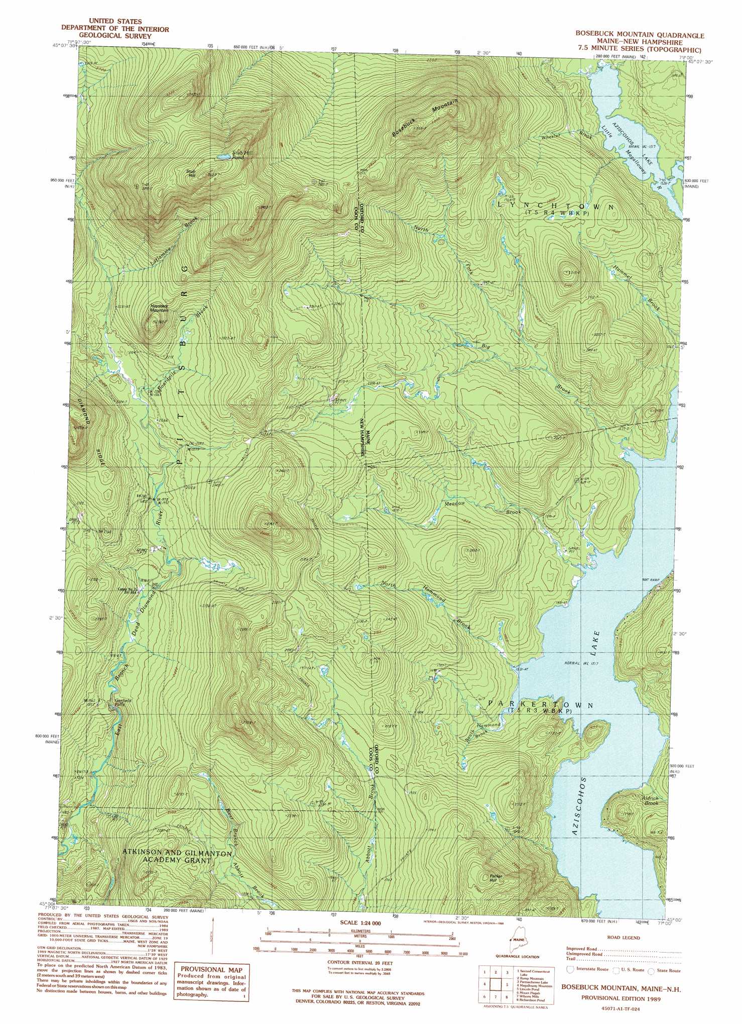
Bosebuck Mountain Topo Map Maine
To zoom in, hover over the map of Bosebuck Mountain
USGS Topo Quad 45071a1 - 1:24,000 scale
| Topo Map Name: | Bosebuck Mountain |
| USGS Topo Quad ID: | 45071a1 |
| Print Size: | ca. 21 1/4" wide x 27" high |
| Southeast Coordinates: | 45° N latitude / 71° W longitude |
| Map Center Coordinates: | 45.0625° N latitude / 71.0625° W longitude |
| U.S. States: | ME, NH |
| Filename: | o45071a1.jpg |
| Download Map JPG Image: | Bosebuck Mountain topo map 1:24,000 scale |
| Map Type: | Topographic |
| Topo Series: | 7.5´ |
| Map Scale: | 1:24,000 |
| Source of Map Images: | United States Geological Survey (USGS) |
| Alternate Map Versions: |
Bosebuck Mountain ME 1976, updated 1983 Download PDF Buy paper map Bosebuck Mountain ME 1989, updated 1989 Download PDF Buy paper map Bosebuck Mountain ME 1989, updated 1989 Download PDF Buy paper map Bosebuck Mountain ME 2011 Download PDF Buy paper map Bosebuck Mountain ME 2014 Download PDF Buy paper map |
1:24,000 Topo Quads surrounding Bosebuck Mountain
Bellefeuille |
Chartierville |
Moose Bog |
Twin Peaks |
Northwest Pond |
Cowen Hill |
Second Connecticut Lake |
Rump Mountain |
Parmachenee Lake |
Little Kennebago Lake |
Lake Francis |
Magalloway Mountain |
Bosebuck Mountain |
Lincoln Pond |
Kennebago |
Diamond Pond |
Mount Pisgah |
Wilsons Mills |
Richardson Pond |
Oquossoc |
Dixville Notch |
Errol |
Umbagog Lake North |
Middle Dam |
Metallak Mountain |
> Back to 45071a1 at 1:100,000 scale
> Back to 45070a1 at 1:250,000 scale
> Back to U.S. Topo Maps home
Bosebuck Mountain topo map: Gazetteer
Bosebuck Mountain: Falls
Garfield Falls elevation 562m 1843′Bosebuck Mountain: Lakes
Stub Hill Pond elevation 1058m 3471′Bosebuck Mountain: Streams
Aldrich Brook elevation 462m 1515′Big Brook elevation 462m 1515′
Big Brook elevation 462m 1515′
Boardpile Brook elevation 628m 2060′
East Branch Dead Diamond River elevation 479m 1571′
La Flamme Brook elevation 659m 2162′
Lincoln Brook elevation 462m 1515′
Little Magalloway River elevation 464m 1522′
Meadow Brook elevation 462m 1515′
Meadow Brook elevation 462m 1515′
Middle Branch Little Magalloway River elevation 464m 1522′
North Fork Big Brook elevation 499m 1637′
North Fork Big Brook elevation 499m 1637′
North Hammond Brook elevation 464m 1522′
North Hammond Brook elevation 464m 1522′
South Hammond Brook elevation 462m 1515′
Wheeler Brook elevation 462m 1515′
Bosebuck Mountain: Summits
Bosebuck Mountain elevation 918m 3011′Haystack Mountain elevation 774m 2539′
Parker Hill elevation 734m 2408′
Stub Hill elevation 1077m 3533′
Bosebuck Mountain digital topo map on disk
Buy this Bosebuck Mountain topo map showing relief, roads, GPS coordinates and other geographical features, as a high-resolution digital map file on DVD:
Maine, New Hampshire, Rhode Island & Eastern Massachusetts
Buy digital topo maps: Maine, New Hampshire, Rhode Island & Eastern Massachusetts