Rush Lake Topo Map Minnesota
To zoom in, hover over the map of Rush Lake
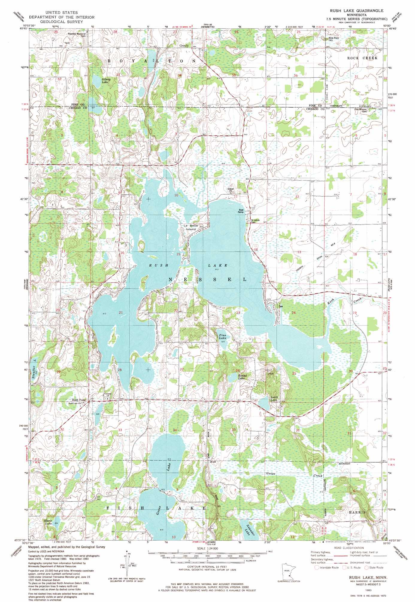
USGS Topo Quad 45093f1 - 1:24,000 scale
| Topo Map Name: | Rush Lake |
| USGS Topo Quad ID: | 45093f1 |
| Print Size: | ca. 21 1/4" wide x 27" high |
| Southeast Coordinates: | 45.625° N latitude / 93° W longitude |
| Map Center Coordinates: | 45.6875° N latitude / 93.0625° W longitude |
| U.S. State: | MN |
| Filename: | o45093f1.jpg |
| Download Map JPG Image: | Rush Lake topo map 1:24,000 scale |
| Map Type: | Topographic |
| Topo Series: | 7.5´ |
| Map Scale: | 1:24,000 |
| Source of Map Images: | United States Geological Survey (USGS) |
| Alternate Map Versions: |
Rush Lake MN 1983, updated 1984 Download PDF Buy paper map Rush Lake MN 2010 Download PDF Buy paper map Rush Lake MN 2013 Download PDF Buy paper map Rush Lake MN 2016 Download PDF Buy paper map |
1:24,000 Topo Quads surrounding Rush Lake
Mora North |
Quamba |
Brook Park |
Beroun |
Cedar Lake |
Mora South |
Grasston |
Henriette |
Pine City |
Bass Creek |
Springvale |
Braham |
Rush Lake |
Rush City |
Randall |
Bradford |
Cambridge |
Stark |
North Branch |
Sunrise |
Saint Francis |
Isanti |
Typo Lake |
Stacy |
Lindstrom |
> Back to 45093e1 at 1:100,000 scale
> Back to 45092a1 at 1:250,000 scale
> Back to U.S. Topo Maps home
Rush Lake topo map: Gazetteer
Rush Lake: Canals
County Ditch Number Eight elevation 282m 925′Rush Lake: Islands
La Belle Island elevation 280m 918′Rush Lake: Lakes
Alexis Lake elevation 284m 931′Goose Lake elevation 278m 912′
Leech Lake elevation 284m 931′
Neander Lake elevation 278m 912′
Pine Lake elevation 281m 921′
Round Lake elevation 280m 918′
Rush Lake elevation 278m 912′
Silberg Lake elevation 287m 941′
Stauffer Lake elevation 284m 931′
Rush Lake: Populated Places
Greely elevation 300m 984′Rush Point elevation 289m 948′
Rush Lake: Post Offices
Rushpoint Post Office (historical) elevation 286m 938′Rush Lake digital topo map on disk
Buy this Rush Lake topo map showing relief, roads, GPS coordinates and other geographical features, as a high-resolution digital map file on DVD: