Cottonwood Creek Sw Topo Map South Dakota
To zoom in, hover over the map of Cottonwood Creek Sw
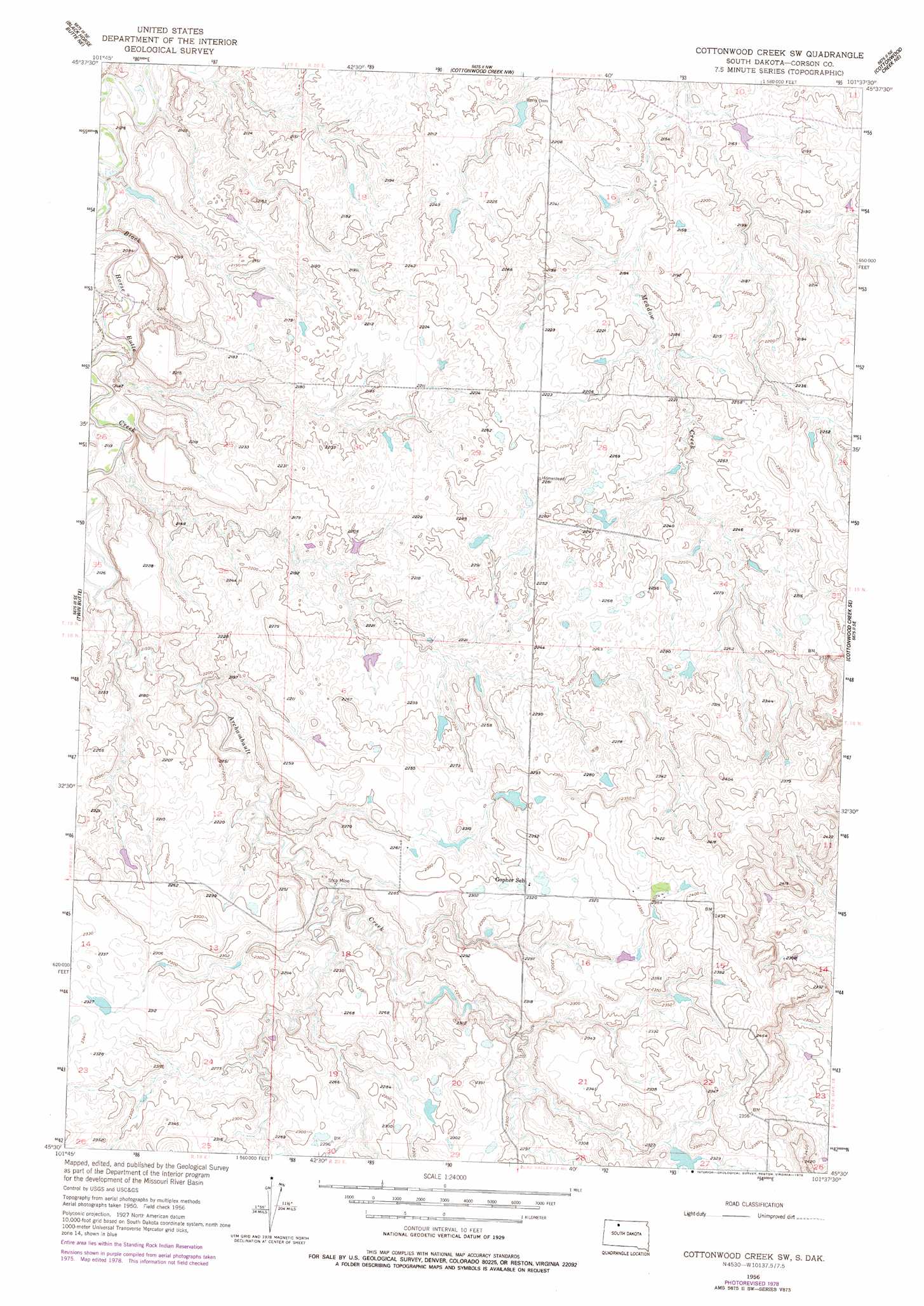
USGS Topo Quad 45101e6 - 1:24,000 scale
| Topo Map Name: | Cottonwood Creek Sw |
| USGS Topo Quad ID: | 45101e6 |
| Print Size: | ca. 21 1/4" wide x 27" high |
| Southeast Coordinates: | 45.5° N latitude / 101.625° W longitude |
| Map Center Coordinates: | 45.5625° N latitude / 101.6875° W longitude |
| U.S. State: | SD |
| Filename: | o45101e6.jpg |
| Download Map JPG Image: | Cottonwood Creek Sw topo map 1:24,000 scale |
| Map Type: | Topographic |
| Topo Series: | 7.5´ |
| Map Scale: | 1:24,000 |
| Source of Map Images: | United States Geological Survey (USGS) |
| Alternate Map Versions: |
Cottonwood Creek SW SD 1956, updated 1957 Download PDF Buy paper map Cottonwood Creek SW SD 1956, updated 1978 Download PDF Buy paper map Cottonwood Creek SW SD 2012 Download PDF Buy paper map Cottonwood Creek SW SD 2015 Download PDF Buy paper map |
1:24,000 Topo Quads surrounding Cottonwood Creek Sw
Thunder Hawk Sw |
Thunder Hawk Se |
Skull Butte |
Morristown Se |
Mcintosh Sw |
Black Horse Butte Nw |
Black Horse Butte Ne |
Cottonwood Creek Nw |
Cottonwood Creek Ne |
Black Horse |
Black Horse Butte |
Twin Butte |
Cottonwood Creek Sw |
Cottonwood Creek Se |
Black Horse Sw |
Glad Valley Nw |
Glad Valley |
Irish Creek Nw |
Irish Creek Ne |
Isabel |
Glad Valley Sw |
Glad Valley Se |
Irish Creek Sw |
Irish Creek Se |
Isabel Sw |
> Back to 45101e1 at 1:100,000 scale
> Back to 45100a1 at 1:250,000 scale
> Back to U.S. Topo Maps home
Cottonwood Creek Sw topo map: Gazetteer
Cottonwood Creek Sw: Dams
Berry Dam elevation 663m 2175′John Alley Dam elevation 706m 2316′
Cottonwood Creek Sw: Streams
Archambault Creek elevation 646m 2119′Cottonwood Creek Sw digital topo map on disk
Buy this Cottonwood Creek Sw topo map showing relief, roads, GPS coordinates and other geographical features, as a high-resolution digital map file on DVD:
Eastern North Dakota & Eastern South Dakota
Buy digital topo maps: Eastern North Dakota & Eastern South Dakota