Vernonia Topo Map Oregon
To zoom in, hover over the map of Vernonia
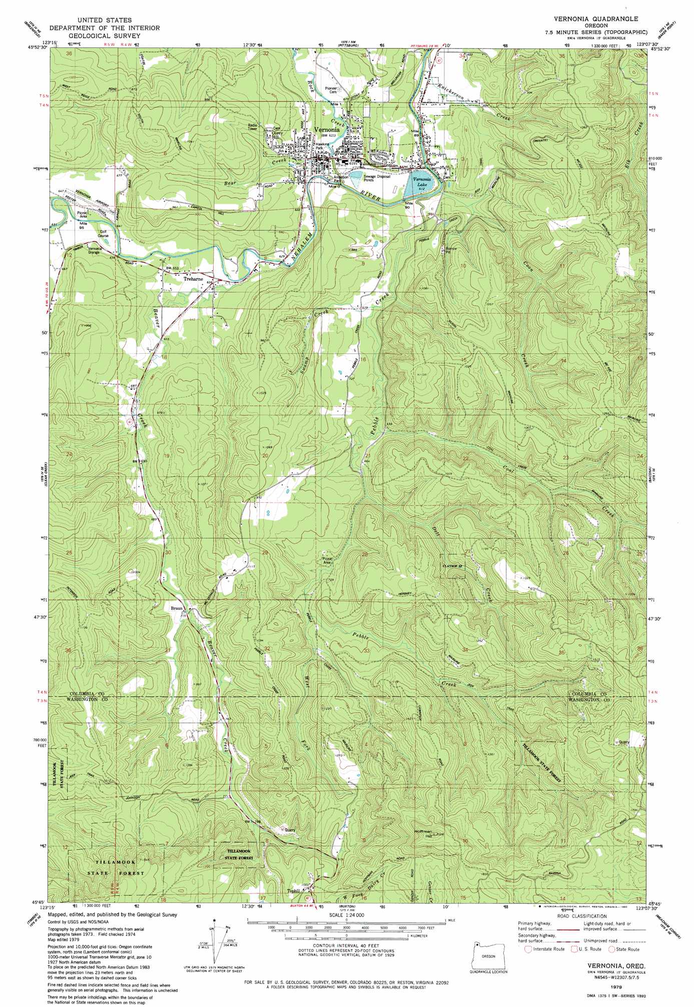
USGS Topo Quad 45123g2 - 1:24,000 scale
| Topo Map Name: | Vernonia |
| USGS Topo Quad ID: | 45123g2 |
| Print Size: | ca. 21 1/4" wide x 27" high |
| Southeast Coordinates: | 45.75° N latitude / 123.125° W longitude |
| Map Center Coordinates: | 45.8125° N latitude / 123.1875° W longitude |
| U.S. State: | OR |
| Filename: | o45123g2.jpg |
| Download Map JPG Image: | Vernonia topo map 1:24,000 scale |
| Map Type: | Topographic |
| Topo Series: | 7.5´ |
| Map Scale: | 1:24,000 |
| Source of Map Images: | United States Geological Survey (USGS) |
| Alternate Map Versions: |
Vernonia OR 1979, updated 1980 Download PDF Buy paper map Vernonia OR 2011 Download PDF Buy paper map Vernonia OR 2014 Download PDF Buy paper map |
1:24,000 Topo Quads surrounding Vernonia
Nicolai Mountain |
Marshland |
Clatskanie |
Delena |
Rainier |
Sager Creek |
Birkenfeld |
Pittsburg |
Baker Point |
Trenholm |
Sunset Spring |
Clear Creek |
Vernonia |
Bacona |
Chapman |
Cochran |
Timber |
Buxton |
Meacham Corner |
Dixie Mountain |
Wood Point |
Roaring Creek |
Gales Creek |
Forest Grove |
Hillsboro |
> Back to 45123e1 at 1:100,000 scale
> Back to 45122a1 at 1:250,000 scale
> Back to U.S. Topo Maps home
Vernonia topo map: Gazetteer
Vernonia: Airports
Vernonia Airfield elevation 197m 646′Vernonia: Dams
Vernonia Log Pond Dike elevation 184m 603′Vernonia: Mines
Smithwick Haydite Quarry elevation 283m 928′Vernonia: Parks
Airport City Park elevation 192m 629′Anderson Park elevation 184m 603′
Hawkins Park elevation 191m 626′
Ora Bolmeier City Park elevation 208m 682′
Rogers Park elevation 202m 662′
Shay 102 City Park elevation 185m 606′
Spencer City Park elevation 205m 672′
Vernonia Lake City Park elevation 186m 610′
Vernonia: Populated Places
Corey Hill elevation 254m 833′Treharne elevation 194m 636′
Vernonia elevation 190m 623′
Vernonia: Post Offices
Albion Post Office (historical) elevation 380m 1246′Anoka Post Office (historical) elevation 215m 705′
Braunsport Post Office (historical) elevation 215m 705′
Pebble Post Office (historical) elevation 226m 741′
Vernonia Post Office elevation 190m 623′
Vernonia: Reservoirs
Vernonia Lake elevation 184m 603′Vernonia: Streams
Bear Creek elevation 184m 603′Beaver Creek elevation 188m 616′
Coal Creek elevation 196m 643′
Coon Creek elevation 184m 603′
Dell Creek elevation 196m 643′
Elk Creek elevation 201m 659′
Knickerson Creek elevation 184m 603′
Pebble Creek elevation 184m 603′
Rock Creek elevation 184m 603′
Swamp Creek elevation 194m 636′
West Fork Pebble Creek elevation 215m 705′
Vernonia: Summits
Cape Horn elevation 459m 1505′Hoffman Hill elevation 614m 2014′
O-A Hill elevation 238m 780′
Vernonia digital topo map on disk
Buy this Vernonia topo map showing relief, roads, GPS coordinates and other geographical features, as a high-resolution digital map file on DVD: