Graff Topo Map Minnesota
To zoom in, hover over the map of Graff
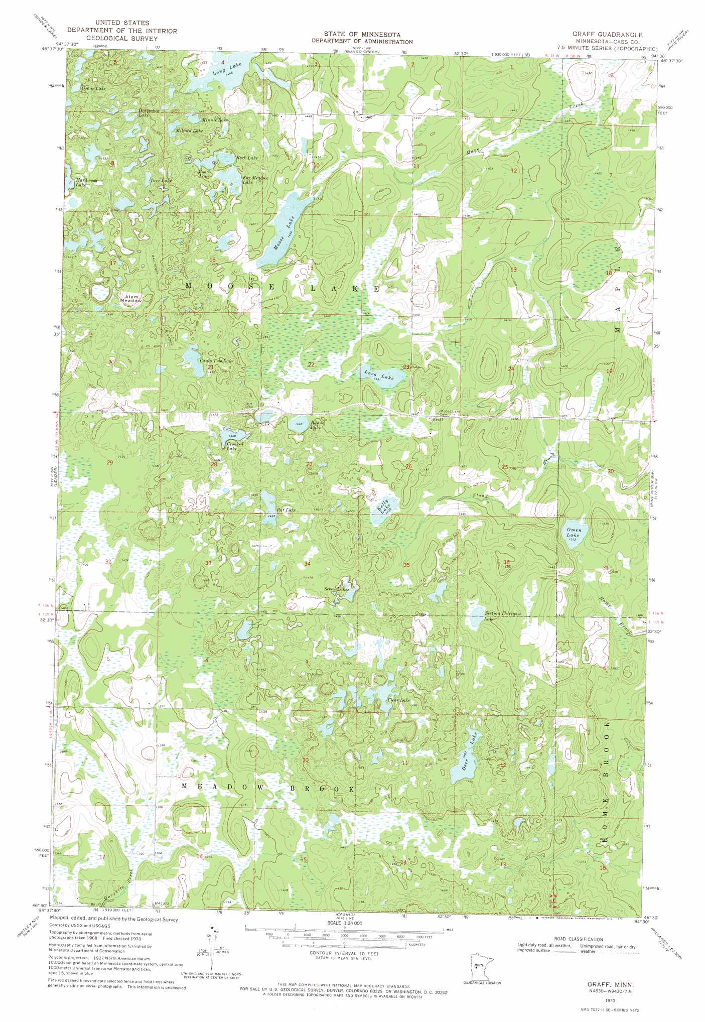
USGS Topo Quad 46094e5 - 1:24,000 scale
| Topo Map Name: | Graff |
| USGS Topo Quad ID: | 46094e5 |
| Print Size: | ca. 21 1/4" wide x 27" high |
| Southeast Coordinates: | 46.5° N latitude / 94.5° W longitude |
| Map Center Coordinates: | 46.5625° N latitude / 94.5625° W longitude |
| U.S. State: | MN |
| Filename: | o46094e5.jpg |
| Download Map JPG Image: | Graff topo map 1:24,000 scale |
| Map Type: | Topographic |
| Topo Series: | 7.5´ |
| Map Scale: | 1:24,000 |
| Source of Map Images: | United States Geological Survey (USGS) |
| Alternate Map Versions: |
Graff MN 1970, updated 1972 Download PDF Buy paper map Graff MN 2010 Download PDF Buy paper map Graff MN 2013 Download PDF Buy paper map Graff MN 2016 Download PDF Buy paper map |
1:24,000 Topo Quads surrounding Graff
First Crow Wing Lake |
Oshawa |
Backus |
Mildred |
Lake Ada |
Burgen Lake |
Spider Lake |
Bungo Creek |
Pine River |
Jenkins |
Oylen |
Leader |
Graff |
Pine River Sw |
Nisswa |
Staples Ne |
Motley Nw |
Casino |
Wilson Bay |
Gull Lake |
Staples |
Motley |
Motley Se |
Pillager |
Baxter |
> Back to 46094e1 at 1:100,000 scale
> Back to 46094a1 at 1:250,000 scale
> Back to U.S. Topo Maps home
Graff topo map: Gazetteer
Graff: Flats
Alem Meadow elevation 465m 1525′Graff: Lakes
Camp Two Lake elevation 449m 1473′Clear Lake elevation 449m 1473′
Crooked Lake elevation 444m 1456′
Deer Lake elevation 446m 1463′
Deer Lake elevation 462m 1515′
Fox Meadow Lake elevation 440m 1443′
Grade Lake elevation 452m 1482′
Hardwood Lake elevation 457m 1499′
Horseshoe Lake elevation 460m 1509′
Kelly Lake elevation 438m 1437′
Long Lake elevation 441m 1446′
Lova Lake elevation 436m 1430′
Milford Lake elevation 448m 1469′
Minnie Lake elevation 445m 1459′
Moore Lake elevation 440m 1443′
Moose Lake elevation 437m 1433′
Omen Lake elevation 418m 1371′
Rat Lake elevation 445m 1459′
Rock Lake elevation 440m 1443′
Round Lake elevation 441m 1446′
Section Thirtysix Lake elevation 444m 1456′
Seven Lakes elevation 443m 1453′
Graff: Populated Places
Graff elevation 438m 1437′Graff: Post Offices
Graff Post Office (historical) elevation 437m 1433′Grant Post Office (historical) elevation 447m 1466′
Graff digital topo map on disk
Buy this Graff topo map showing relief, roads, GPS coordinates and other geographical features, as a high-resolution digital map file on DVD: