Mcclure Reservoir Topo Map Montana
To zoom in, hover over the map of Mcclure Reservoir
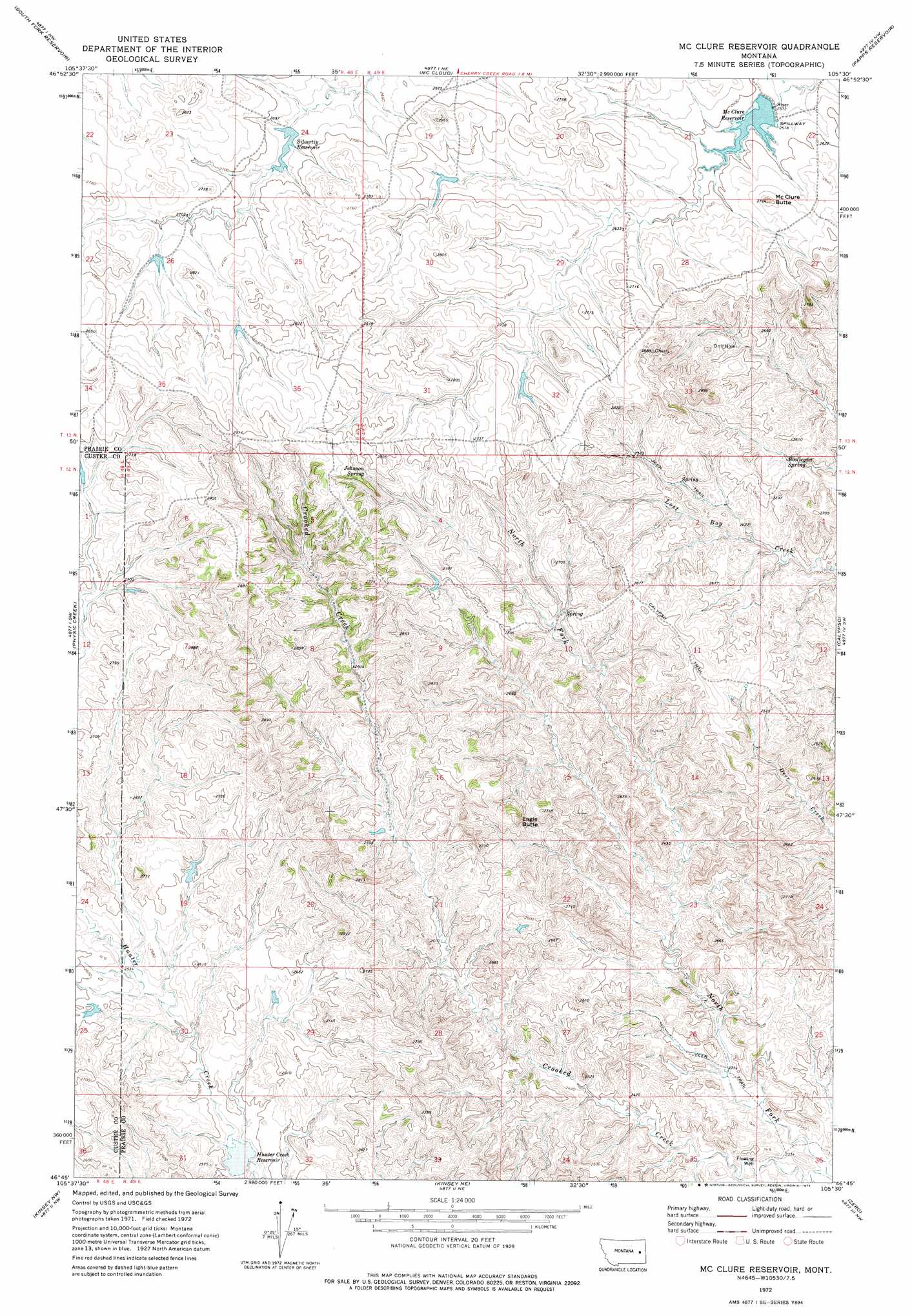
USGS Topo Quad 46105g5 - 1:24,000 scale
| Topo Map Name: | Mcclure Reservoir |
| USGS Topo Quad ID: | 46105g5 |
| Print Size: | ca. 21 1/4" wide x 27" high |
| Southeast Coordinates: | 46.75° N latitude / 105.5° W longitude |
| Map Center Coordinates: | 46.8125° N latitude / 105.5625° W longitude |
| U.S. State: | MT |
| Filename: | o46105g5.jpg |
| Download Map JPG Image: | Mcclure Reservoir topo map 1:24,000 scale |
| Map Type: | Topographic |
| Topo Series: | 7.5´ |
| Map Scale: | 1:24,000 |
| Source of Map Images: | United States Geological Survey (USGS) |
| Alternate Map Versions: |
Mc Clure Reservoir MT 1972, updated 1975 Download PDF Buy paper map McClure Reservoir MT 2011 Download PDF Buy paper map McClure Reservoir MT 2014 Download PDF Buy paper map |
1:24,000 Topo Quads surrounding Mcclure Reservoir
Watkins Se |
Big Sheep Mountain |
Becker Dam |
North Coulee |
Diamond G Butte |
Little Sheep Mountain |
South Fork Reservoir |
Mccloud |
Papps Reservoir |
Diamond G Creek |
Morehouse Creek |
Physic Creek |
Mcclure Reservoir |
Calypso |
Terry |
Coal Bank Spring |
Kinsey Nw |
Kinsey Ne |
Zero |
Zero Ne |
Noble Reservoir |
Kinsey |
Shirley |
Corral Butte |
Spring Draw |
> Back to 46105e1 at 1:100,000 scale
> Back to 46104a1 at 1:250,000 scale
> Back to U.S. Topo Maps home
Mcclure Reservoir topo map: Gazetteer
Mcclure Reservoir: Dams
Bn Number 100 Dam elevation 863m 2831′Hawk Dam elevation 784m 2572′
Hines Number 1 Dam elevation 810m 2657′
Hines Number 2 Dam elevation 817m 2680′
Hunter Creek Dam elevation 753m 2470′
Silvertip Dam elevation 813m 2667′
Mcclure Reservoir: Reservoirs
Hunter Creek Reservoir elevation 751m 2463′McClure Reservoir elevation 779m 2555′
Silvertip Reservoir elevation 809m 2654′
Mcclure Reservoir: Springs
Bootlegger Spring elevation 769m 2522′Johnson Spring elevation 834m 2736′
Mcclure Reservoir: Summits
Eagle Butte elevation 842m 2762′McClure Butte elevation 826m 2709′
Mcclure Reservoir: Wells
13N48E26ABDB01 Well elevation 823m 2700′Mcclure Reservoir digital topo map on disk
Buy this Mcclure Reservoir topo map showing relief, roads, GPS coordinates and other geographical features, as a high-resolution digital map file on DVD:
Eastern Montana & Western North Dakota
Buy digital topo maps: Eastern Montana & Western North Dakota