Sanders Topo Map Montana
To zoom in, hover over the map of Sanders
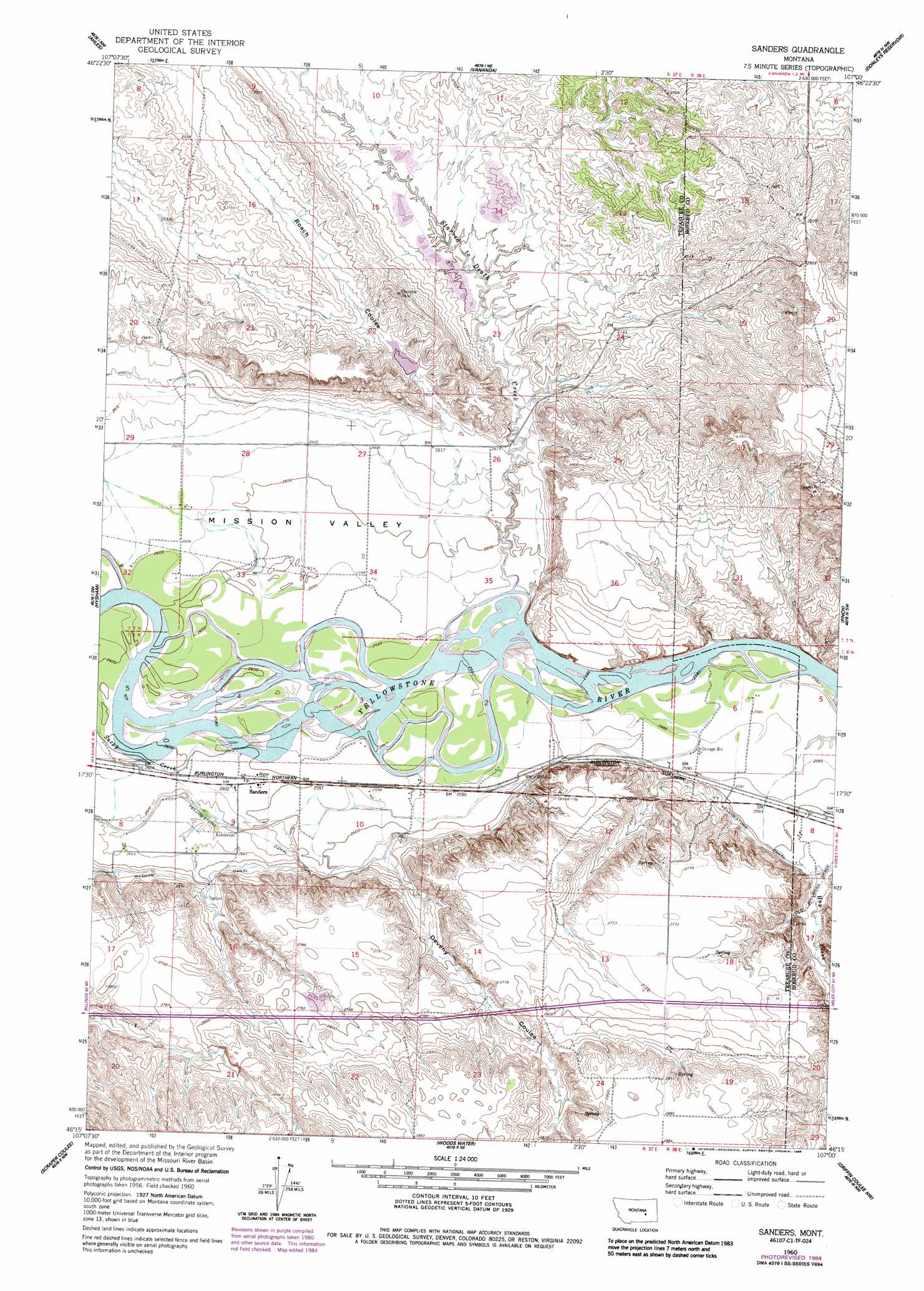
USGS Topo Quad 46107c1 - 1:24,000 scale
| Topo Map Name: | Sanders |
| USGS Topo Quad ID: | 46107c1 |
| Print Size: | ca. 21 1/4" wide x 27" high |
| Southeast Coordinates: | 46.25° N latitude / 107° W longitude |
| Map Center Coordinates: | 46.3125° N latitude / 107.0625° W longitude |
| U.S. State: | MT |
| Filename: | o46107c1.jpg |
| Download Map JPG Image: | Sanders topo map 1:24,000 scale |
| Map Type: | Topographic |
| Topo Series: | 7.5´ |
| Map Scale: | 1:24,000 |
| Source of Map Images: | United States Geological Survey (USGS) |
| Alternate Map Versions: |
Sanders MT 1960, updated 1962 Download PDF Buy paper map Sanders MT 1960, updated 1985 Download PDF Buy paper map Sanders MT 2011 Download PDF Buy paper map Sanders MT 2014 Download PDF Buy paper map |
1:24,000 Topo Quads surrounding Sanders
Ingomar East |
Thebes |
Zempel Lake |
Flat Bottom Coulee Sw |
Flat Bottom Coulee Se |
Steie Ranch |
Ahles |
Vananda |
Donleys Reservoir |
Finch Ne |
Myers |
Hysham |
Sanders |
Finch |
Nichols |
Eldering Ranch |
Scraper Coulee |
Woods Water |
Griffin Coulee Nw |
Griffin Coulee Ne |
Hope Ranch |
South Bear Creek |
Minnehaha Creek North |
Griffin Coulee Sw |
Griffin Coulee |
> Back to 46107a1 at 1:100,000 scale
> Back to 46106a1 at 1:250,000 scale
> Back to U.S. Topo Maps home
Sanders topo map: Gazetteer
Sanders: Canals
Yellowstone Canal elevation 798m 2618′Sanders: Dams
Deveny Coulee Dam elevation 847m 2778′Fred Smith Dam elevation 811m 2660′
Sanders: Mines
SE Starved to Death-14 Mine elevation 814m 2670′South Cedar Ridge Mine elevation 855m 2805′
Starved To Death Haul Road - Nine Mine elevation 825m 2706′
SW Cedar Ridge Complex Mine elevation 828m 2716′
SW Cedar Ridge-13 Mine elevation 842m 2762′
SW Starved to Death Mine elevation 810m 2657′
SW Starved to Death-15 Mine elevation 810m 2657′
SW Starved to Death-15 N and E Mine elevation 811m 2660′
SW Starved to Death-23 Mine elevation 807m 2647′
Sanders: Populated Places
Sanders elevation 793m 2601′Sanders: Post Offices
Sanders Post Office (historical) elevation 794m 2604′Sanders: Streams
Sarpy Creek elevation 793m 2601′Starved to Death Creek elevation 790m 2591′
Sanders: Valleys
Deveny Coulee elevation 799m 2621′Mission Valley elevation 789m 2588′
Roach Coulee elevation 789m 2588′
Sanders: Wells
06N37E09A___01 Well elevation 793m 2601′06N37E09B___01 Well elevation 796m 2611′
07N37E26D___01 Well elevation 797m 2614′
07N37E28C___01 Well elevation 795m 2608′
Sanders digital topo map on disk
Buy this Sanders topo map showing relief, roads, GPS coordinates and other geographical features, as a high-resolution digital map file on DVD:
Eastern Montana & Western North Dakota
Buy digital topo maps: Eastern Montana & Western North Dakota