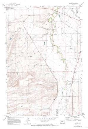
Sipple Topo Map Montana
To zoom in, hover over the map of Sipple
USGS Topo Quad 46109h7 - 1:24,000 scale
| Topo Map Name: | Sipple |
| USGS Topo Quad ID: | 46109h7 |
| Print Size: | ca. 21 1/4" wide x 27" high |
| Southeast Coordinates: | 46.875° N latitude / 109.75° W longitude |
| Map Center Coordinates: | 46.9375° N latitude / 109.8125° W longitude |
| U.S. State: | MT |
| Filename: | o46109h7.jpg |
| Download Map JPG Image: | Sipple topo map 1:24,000 scale |
| Map Type: | Topographic |
| Topo Series: | 7.5´ |
| Map Scale: | 1:24,000 |
| Source of Map Images: | United States Geological Survey (USGS) |
| Alternate Map Versions: |
Sipple MT 1970, updated 1974 Download PDF Buy paper map Sipple MT 2011 Download PDF Buy paper map Sipple MT 2014 Download PDF Buy paper map |
1:24,000 Topo Quads surrounding Sipple
> Back to 46109e1 at 1:100,000 scale
> Back to 46108a1 at 1:250,000 scale
> Back to U.S. Topo Maps home
Sipple topo map: Gazetteer
Sipple: Dams
Aries Dam elevation 1193m 3914′Dolomites Dam elevation 1214m 3982′
Haven Reservoir Dam elevation 1255m 4117′
Miller Brothers Livestock Reservoir Dam elevation 1209m 3966′
Rung Reservoir Dam elevation 1302m 4271′
Sipple: Populated Places
Hauck elevation 1225m 4019′Sipple elevation 1248m 4094′
Sipple: Post Offices
Mendon Post Office (historical) elevation 1252m 4107′Sipple: Springs
13N15E11BC__01 Spring elevation 1253m 4110′13N15E15CC__01 Spring elevation 1277m 4189′
14N15E08BC__01 Spring elevation 1257m 4124′
14N15E08CB__01 Spring elevation 1256m 4120′
14N15E11CA__01 Spring elevation 1197m 3927′
14N15E11DB__01 Spring elevation 1196m 3923′
14N15E18AB__01 Spring elevation 1260m 4133′
14N15E18BB__02 Spring elevation 1260m 4133′
14N15E20AA__01 Spring elevation 1222m 4009′
14N15E33CD__01 Spring elevation 1260m 4133′
Sipple: Streams
Little Trout Creek elevation 1235m 4051′Sipple: Valleys
Big Coulee elevation 1238m 4061′Hauck Coulee elevation 1188m 3897′
Weber Coulee elevation 1278m 4192′
Sipple: Wells
13N15E01CA__01 Well elevation 1247m 4091′13N15E01CA__02 Well elevation 1247m 4091′
13N15E01CA__03 Well elevation 1247m 4091′
13N15E01CADC01 Well elevation 1243m 4078′
13N15E11BD__01 Well elevation 1247m 4091′
13N15E12BA__01 Well elevation 1248m 4094′
13N15E12DC__01 Well elevation 1261m 4137′
13N15E13DD__01 Well elevation 1287m 4222′
13N15E13DD__02 Well elevation 1287m 4222′
13N15E13DD__03 Well elevation 1287m 4222′
13N15E17AA__01 Well elevation 1328m 4356′
13N15E17AA__02 Well elevation 1335m 4379′
13N15E17AA__03 Well elevation 1335m 4379′
13N15E17AAAA01 Well elevation 1336m 4383′
13N16E19BB__01 Well elevation 1305m 4281′
14N15E06DCBD01 Well elevation 1252m 4107′
14N15E07BA__01 Well elevation 1263m 4143′
14N15E07BA__02 Well elevation 1263m 4143′
14N15E07BA__03 Well elevation 1263m 4143′
14N15E07BA__04 Well elevation 1263m 4143′
14N15E07BA__05 Well elevation 1263m 4143′
14N15E11BDAC01 Well elevation 1186m 3891′
14N15E13CD__01 Well elevation 1216m 3989′
14N15E13CD__02 Well elevation 1216m 3989′
14N15E13CD__03 Well elevation 1216m 3989′
14N15E18AA__01 Well elevation 1263m 4143′
14N15E18DD__01 Well elevation 1248m 4094′
14N15E19CA__01 Well elevation 1267m 4156′
14N15E19CA__02 Well elevation 1267m 4156′
14N15E20DC__01 Well elevation 1225m 4019′
14N15E23BA__01 Well elevation 1208m 3963′
14N15E23BA__02 Well elevation 1208m 3963′
14N15E24CA__01 Well elevation 1219m 3999′
14N15E26DD__01 Well elevation 1223m 4012′
14N15E28BA__01 Well elevation 1227m 4025′
14N15E28CB__01 Well elevation 1242m 4074′
14N15E29BB__01 Well elevation 1245m 4084′
14N15E30AA__01 Well elevation 1221m 4005′
14N15E32AA__01 Well elevation 1257m 4124′
14N15E35AA__01 Well elevation 1220m 4002′
14N15E35AA__02 Well elevation 1220m 4002′
14N15E35AA__03 Well elevation 1220m 4002′
Sipple digital topo map on disk
Buy this Sipple topo map showing relief, roads, GPS coordinates and other geographical features, as a high-resolution digital map file on DVD:


