Whites City Topo Map Montana
To zoom in, hover over the map of Whites City
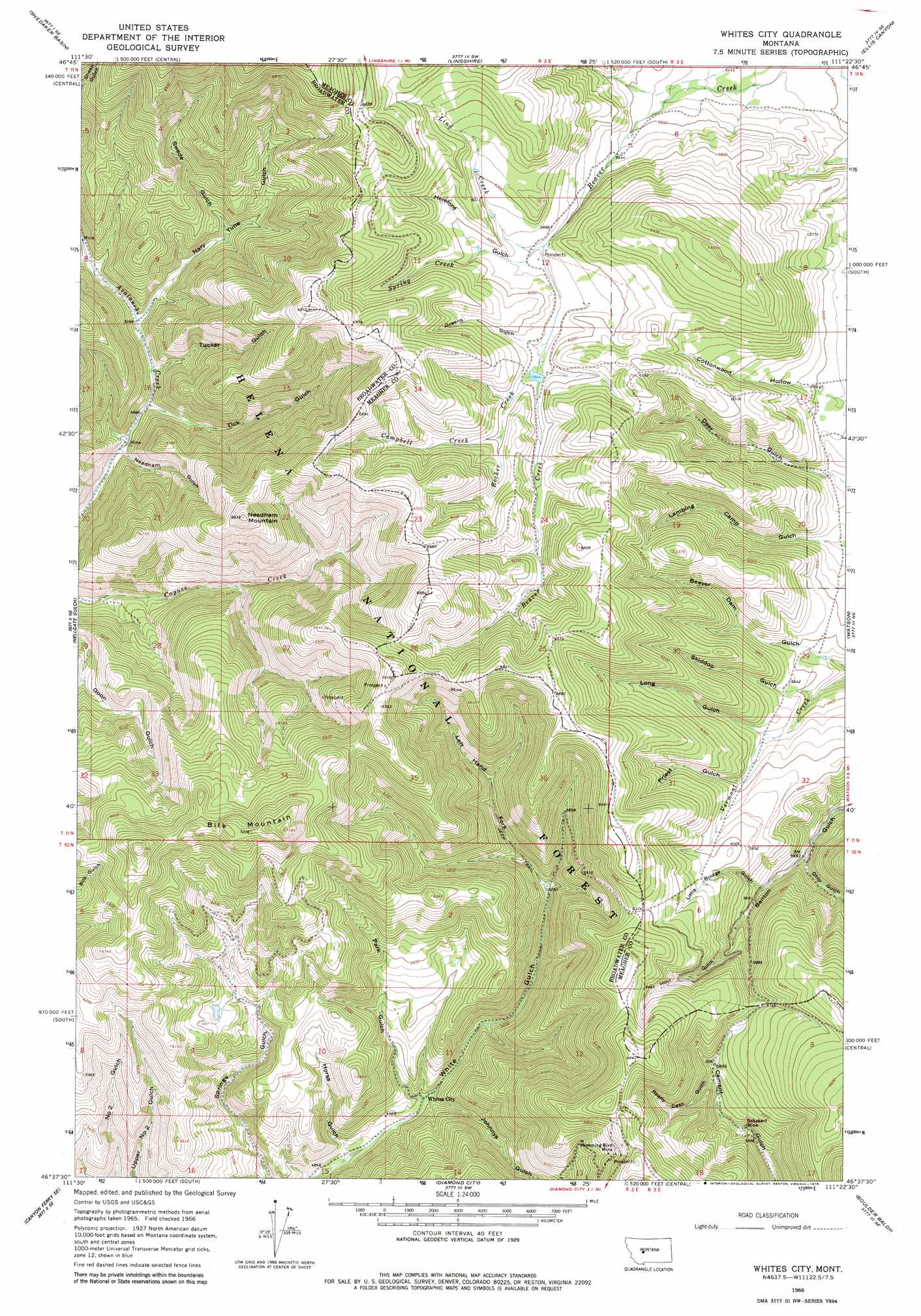
USGS Topo Quad 46111f4 - 1:24,000 scale
| Topo Map Name: | Whites City |
| USGS Topo Quad ID: | 46111f4 |
| Print Size: | ca. 21 1/4" wide x 27" high |
| Southeast Coordinates: | 46.625° N latitude / 111.375° W longitude |
| Map Center Coordinates: | 46.6875° N latitude / 111.4375° W longitude |
| U.S. State: | MT |
| Filename: | o46111f4.jpg |
| Download Map JPG Image: | Whites City topo map 1:24,000 scale |
| Map Type: | Topographic |
| Topo Series: | 7.5´ |
| Map Scale: | 1:24,000 |
| Source of Map Images: | United States Geological Survey (USGS) |
| Alternate Map Versions: |
Whites City MT 1966, updated 1970 Download PDF Buy paper map Whites City MT 1966, updated 1979 Download PDF Buy paper map Whites City MT 2001, updated 2004 Download PDF Buy paper map Whites City MT 2011 Download PDF Buy paper map Whites City MT 2014 Download PDF Buy paper map |
| FStopo: | US Forest Service topo Whites City is available: Download FStopo PDF Download FStopo TIF |
1:24,000 Topo Quads surrounding Whites City
Middle Creek Lake |
B K Ranch |
Lingshire Nw |
Lingshire Ne |
Bald Hills |
Hogback Mountain |
Snedaker Basin |
Lingshire |
Ellis Canyon |
Devils Footstool |
Canyon Ferry |
Hellgate Gulch |
Whites City |
Watson |
Fort Logan |
Canyon Ferry Sw |
Canyon Ferry Se |
Diamond City |
Boulder Baldy |
Gipsy Lake |
Winston |
Townsend Ne |
Gurnett Creek West |
Gurnett Creek East |
Mount Edith |
> Back to 46111e1 at 1:100,000 scale
> Back to 46110a1 at 1:250,000 scale
> Back to U.S. Topo Maps home
Whites City topo map: Gazetteer
Whites City: Mines
Benton Gulch Mine elevation 1942m 6371′Humming Bird Mine elevation 2009m 6591′
Hummingbird Mine elevation 1972m 6469′
Needham Gulch Mine elevation 1529m 5016′
Schabert Mine elevation 1748m 5734′
Schabert Mine elevation 1718m 5636′
SE SE Section 26 Mine elevation 1969m 6459′
Whites City: Populated Places
Whites City elevation 1524m 5000′Whites City: Post Offices
Whites Post Office (historical) elevation 1524m 5000′Whites City: Streams
Campbell Creek elevation 1832m 6010′Lind Creek elevation 1785m 5856′
Rocker Creek elevation 1813m 5948′
Spring Creek elevation 1813m 5948′
Thompson Creek elevation 1570m 5150′
Whites City: Summits
Bilk Mountain elevation 2236m 7335′Cayuse Mountain elevation 2153m 7063′
Needham Mountain elevation 2055m 6742′
Whites City: Valleys
Greens Gulch elevation 1803m 5915′Hereford Gulch elevation 1796m 5892′
Horse Gulch elevation 1485m 4872′
Hour Gulch elevation 1734m 5688′
Johnnies Gulch elevation 1539m 5049′
Left Hand Fork White Gulch elevation 1618m 5308′
Little Bridge Canyon elevation 1713m 5620′
Long Gulch elevation 1731m 5679′
Nary Time Gulch elevation 1546m 5072′
Needham Gulch elevation 1534m 5032′
Ohio Gulch elevation 1671m 5482′
Park Gulch elevation 1522m 4993′
Priest Gulch elevation 1754m 5754′
Ready Cash Gulch elevation 1779m 5836′
Skiddoo Gulch elevation 1684m 5524′
Swede Gulch elevation 1611m 5285′
Tick Gulch elevation 1529m 5016′
Tucker Gulch elevation 1548m 5078′
Whites City digital topo map on disk
Buy this Whites City topo map showing relief, roads, GPS coordinates and other geographical features, as a high-resolution digital map file on DVD: