Union Peak Topo Map Montana
To zoom in, hover over the map of Union Peak
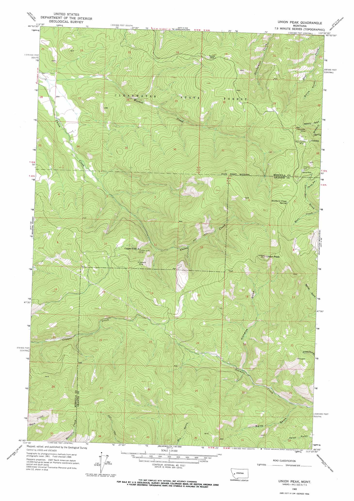
USGS Topo Quad 46113g4 - 1:24,000 scale
| Topo Map Name: | Union Peak |
| USGS Topo Quad ID: | 46113g4 |
| Print Size: | ca. 21 1/4" wide x 27" high |
| Southeast Coordinates: | 46.75° N latitude / 113.375° W longitude |
| Map Center Coordinates: | 46.8125° N latitude / 113.4375° W longitude |
| U.S. State: | MT |
| Filename: | o46113g4.jpg |
| Download Map JPG Image: | Union Peak topo map 1:24,000 scale |
| Map Type: | Topographic |
| Topo Series: | 7.5´ |
| Map Scale: | 1:24,000 |
| Source of Map Images: | United States Geological Survey (USGS) |
| Alternate Map Versions: |
Union Peak MT 1965, updated 1967 Download PDF Buy paper map Union Peak MT 2011 Download PDF Buy paper map Union Peak MT 2014 Download PDF Buy paper map |
1:24,000 Topo Quads surrounding Union Peak
Gold Creek Peak |
Belmont Point |
Salmon Lake |
Woodworth |
Ovando |
Sunflower Mountain |
Potomac |
Greenough |
Bata Mountain |
Chamberlain Mountain |
Clinton |
Mineral Ridge |
Union Peak |
Elevation Mountain |
Wild Horse Parks |
Iris Point |
Ravenna |
Medicine Tree Hill |
Bearmouth |
Drummond |
Grizzly Point |
Spink Point |
Harvey Point |
Nirling Hill |
Hall |
> Back to 46113e1 at 1:100,000 scale
> Back to 46112a1 at 1:250,000 scale
> Back to U.S. Topo Maps home
Union Peak topo map: Gazetteer
Union Peak: Flats
Coyote Park elevation 1616m 5301′Sand Park elevation 1852m 6076′
Union Peak: Mines
Cato Mine elevation 1825m 5987′Clemantha Mine elevation 1796m 5892′
Clemantha Mine elevation 1746m 5728′
Comet Mine elevation 1547m 5075′
Copper Cliff Mine elevation 1563m 5127′
Deer Creek Mine elevation 1584m 5196′
Frogs Diner Mine elevation 1420m 4658′
Leonard Mine elevation 1611m 5285′
Leonard Mine elevation 1684m 5524′
Mammoth Junior Mine elevation 1641m 5383′
Mammoth Mine elevation 1818m 5964′
Mammoth Mine elevation 1820m 5971′
SW Section 32 Mine elevation 1748m 5734′
Union Peak: Populated Places
Coloma elevation 1807m 5928′Copper Cliff elevation 1521m 4990′
Union Peak: Post Offices
Cliff Post Office (historical) elevation 1521m 4990′Coloma Post Office (historical) elevation 1807m 5928′
Union Peak: Springs
Southern Cross Spring elevation 1848m 6062′Union Peak: Streams
Chicken Run elevation 1778m 5833′Washoe Creek elevation 1220m 4002′
Union Peak: Summits
Union Peak elevation 2079m 6820′Union Peak: Valleys
Baldy Gulch elevation 1395m 4576′Bivins Gulch elevation 1396m 4580′
Cannonball Gulch elevation 1715m 5626′
Klondike Gulch elevation 1481m 4858′
Melhorn Gulch elevation 1594m 5229′
Union Peak digital topo map on disk
Buy this Union Peak topo map showing relief, roads, GPS coordinates and other geographical features, as a high-resolution digital map file on DVD: