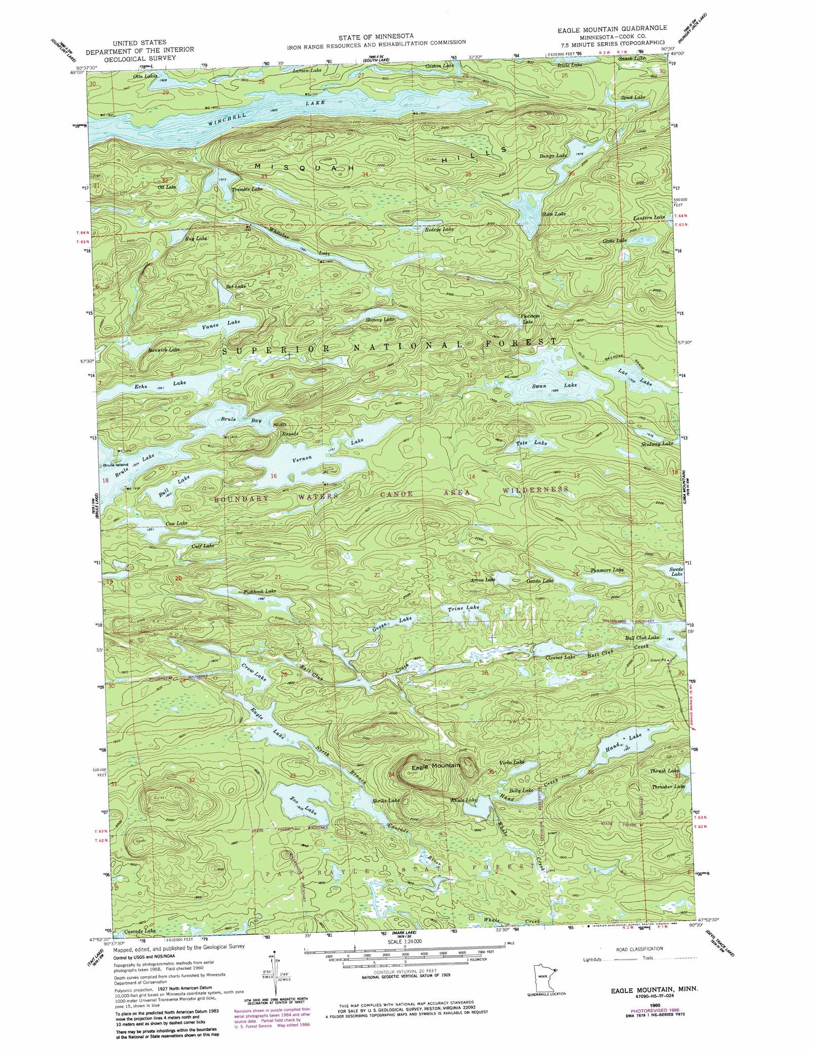
Eagle Mountain Topo Map Minnesota
To zoom in, hover over the map of Eagle Mountain
USGS Topo Quad 47090h5 - 1:24,000 scale
| Topo Map Name: | Eagle Mountain |
| USGS Topo Quad ID: | 47090h5 |
| Print Size: | ca. 21 1/4" wide x 27" high |
| Southeast Coordinates: | 47.875° N latitude / 90.5° W longitude |
| Map Center Coordinates: | 47.9375° N latitude / 90.5625° W longitude |
| U.S. State: | MN |
| Filename: | o47090h5.jpg |
| Download Map JPG Image: | Eagle Mountain topo map 1:24,000 scale |
| Map Type: | Topographic |
| Topo Series: | 7.5´ |
| Map Scale: | 1:24,000 |
| Source of Map Images: | United States Geological Survey (USGS) |
| Alternate Map Versions: |
Eagle Mountain MN 1960, updated 1962 Download PDF Buy paper map Eagle Mountain MN 1960, updated 1965 Download PDF Buy paper map Eagle Mountain MN 1960, updated 1986 Download PDF Buy paper map Eagle Mountain MN 2011 Download PDF Buy paper map Eagle Mountain MN 2013 Download PDF Buy paper map Eagle Mountain MN 2016 Download PDF Buy paper map |
| FStopo: | US Forest Service topo Eagle Mountain is available: Download FStopo PDF Download FStopo TIF |
1:24,000 Topo Quads surrounding Eagle Mountain
Conners Island |
||||
Long Island Lake |
Gunflint Lake |
South Lake |
Hungry Jack Lake |
Crocodile Lake |
Cherokee Lake |
Brule Lake |
Eagle Mountain |
Lima Mountain |
Pine Mountain |
Sawbill Camp |
Tait Lake |
Mark Lake |
Devil Track Lake |
Grand Marais |
Honeymoon Mountain |
Lutsen |
Deer Yard Lake |
Good Harbor Bay |
> Back to 47090e1 at 1:100,000 scale
> Back to 47090a1 at 1:250,000 scale
> Back to U.S. Topo Maps home
Eagle Mountain topo map: Gazetteer
Eagle Mountain: Bays
Brule Bay elevation 559m 1833′Eagle Mountain: Lakes
Arena Lake elevation 606m 1988′Bannick Lake elevation 588m 1929′
Belly Lake elevation 582m 1909′
Bet Lake elevation 618m 2027′
Bull Lake elevation 550m 1804′
Bunga Lake elevation 603m 1978′
Calf Lake elevation 570m 1870′
Cleaver Lake elevation 576m 1889′
Cow Lake elevation 564m 1850′
Crow Lake elevation 564m 1850′
Eagle Lake elevation 557m 1827′
Echo Lake elevation 561m 1840′
Fishhook Lake elevation 604m 1981′
Footsteps Lake elevation 564m 1850′
Globe Lake elevation 619m 2030′
Goose Lake elevation 582m 1909′
Hand Lake elevation 609m 1998′
Icicle Lake elevation 571m 1873′
Lac Lake elevation 519m 1702′
Ott Lake elevation 624m 2047′
Ozada Lake elevation 595m 1952′
Redeye Lake elevation 631m 2070′
Rug Lake elevation 606m 1988′
Shrike Lake elevation 557m 1827′
Skinny Lake elevation 595m 1952′
Spud Lake elevation 582m 1909′
State Lake elevation 607m 1991′
Swan Lake elevation 515m 1689′
Swede Lake elevation 582m 1909′
Tote Lake elevation 540m 1771′
Tremble Lake elevation 600m 1968′
Trine Lake elevation 582m 1909′
Tunmore Lake elevation 600m 1968′
Vance Lake elevation 594m 1948′
Vernon Lake elevation 534m 1751′
Vireo Lake elevation 595m 1952′
Whale Lake elevation 576m 1889′
Whitaker Lake elevation 607m 1991′
Winchell Lake elevation 579m 1899′
Zoo Lake elevation 560m 1837′
Eagle Mountain: Ranges
Misquah Hills elevation 659m 2162′Eagle Mountain: Streams
Ball Club Creek elevation 588m 1929′Hand Creek elevation 576m 1889′
Eagle Mountain: Summits
Eagle Mountain elevation 700m 2296′Eagle Mountain digital topo map on disk
Buy this Eagle Mountain topo map showing relief, roads, GPS coordinates and other geographical features, as a high-resolution digital map file on DVD: