Ojibway Lake Topo Map Minnesota
To zoom in, hover over the map of Ojibway Lake
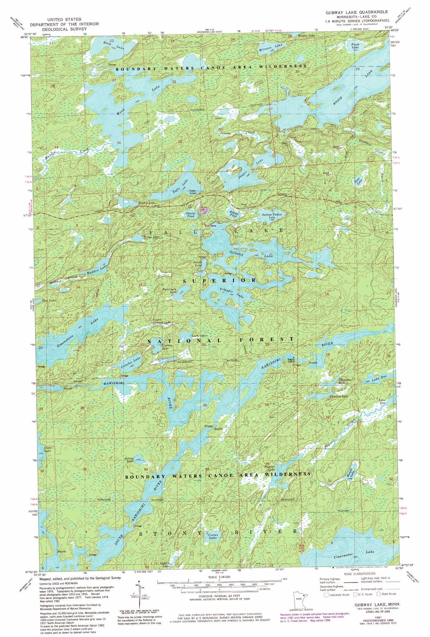
USGS Topo Quad 47091h5 - 1:24,000 scale
| Topo Map Name: | Ojibway Lake |
| USGS Topo Quad ID: | 47091h5 |
| Print Size: | ca. 21 1/4" wide x 27" high |
| Southeast Coordinates: | 47.875° N latitude / 91.5° W longitude |
| Map Center Coordinates: | 47.9375° N latitude / 91.5625° W longitude |
| U.S. State: | MN |
| Filename: | o47091h5.jpg |
| Download Map JPG Image: | Ojibway Lake topo map 1:24,000 scale |
| Map Type: | Topographic |
| Topo Series: | 7.5´ |
| Map Scale: | 1:24,000 |
| Source of Map Images: | United States Geological Survey (USGS) |
| Alternate Map Versions: |
Ojibway Lake MN 1981, updated 1982 Download PDF Buy paper map Ojibway Lake MN 1981, updated 1986 Download PDF Buy paper map Ojibway Lake MN 2011 Download PDF Buy paper map Ojibway Lake MN 2013 Download PDF Buy paper map Ojibway Lake MN 2016 Download PDF Buy paper map |
| FStopo: | US Forest Service topo Ojibway Lake is available: Download FStopo PDF Download FStopo TIF |
1:24,000 Topo Quads surrounding Ojibway Lake
Friday Bay |
Jackfish Lake |
|||
Fourtown Lake |
Basswood Lake West |
Basswood Lake East |
Ensign Lake West |
Ensign Lake East |
Ely |
Farm Lake |
Ojibway Lake |
Snowbank Lake |
Lake Insula |
Kangas Bay |
Bogberry Lake |
Gabbro Lake |
Quadga Lake |
Isabella Lake |
Babbitt Ne |
Slate Lake West |
Slate Lake East |
Mitawan Lake |
Sawbill Landing |
> Back to 47091e1 at 1:100,000 scale
> Back to 47090a1 at 1:250,000 scale
> Back to U.S. Topo Maps home
Ojibway Lake topo map: Gazetteer
Ojibway Lake: Lakes
Astray Lake elevation 441m 1446′Carefree Lake elevation 450m 1476′
Clearwater Lake elevation 459m 1505′
Conchu Lake elevation 443m 1453′
Cortes Lake elevation 450m 1476′
Finch Lake elevation 410m 1345′
Gem Lake elevation 438m 1437′
Glacier Pond elevation 454m 1489′
Greenstone Lake elevation 446m 1463′
Hula Lake elevation 406m 1332′
Jasper Lake elevation 422m 1384′
Jewell Lake elevation 454m 1489′
Kamimela Lake elevation 463m 1519′
Lark Lake elevation 462m 1515′
Madden Lake elevation 450m 1476′
Ojibway Lake elevation 452m 1482′
Pagami Lake elevation 450m 1476′
Plukesley Lake elevation 450m 1476′
Refuge Pond elevation 442m 1450′
Rookie Lake elevation 423m 1387′
Section Twelve Lake elevation 448m 1469′
Tofte Lake elevation 436m 1430′
Triangle Lake elevation 453m 1486′
Upper Uranus Lake elevation 451m 1479′
Uranus Lake elevation 456m 1496′
Weasel Lake elevation 457m 1499′
Wedge Lake elevation 451m 1479′
Witness Lake elevation 423m 1387′
Wood Lake elevation 410m 1345′
Ojibway Lake: Streams
Jasper Creek elevation 413m 1354′Madden Creek elevation 410m 1345′
Pagami Creek elevation 448m 1469′
Uncle Judas Creek elevation 415m 1361′
Ojibway Lake digital topo map on disk
Buy this Ojibway Lake topo map showing relief, roads, GPS coordinates and other geographical features, as a high-resolution digital map file on DVD: