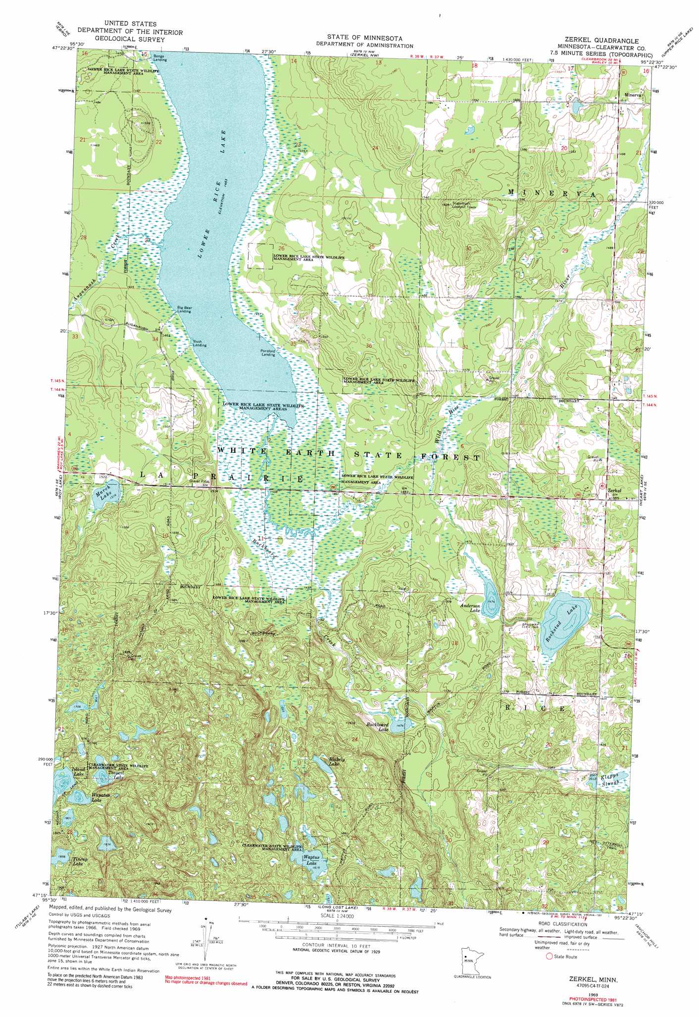
Zerkel Topo Map Minnesota
To zoom in, hover over the map of Zerkel
USGS Topo Quad 47095c4 - 1:24,000 scale
| Topo Map Name: | Zerkel |
| USGS Topo Quad ID: | 47095c4 |
| Print Size: | ca. 21 1/4" wide x 27" high |
| Southeast Coordinates: | 47.25° N latitude / 95.375° W longitude |
| Map Center Coordinates: | 47.3125° N latitude / 95.4375° W longitude |
| U.S. State: | MN |
| Filename: | o47095c4.jpg |
| Download Map JPG Image: | Zerkel topo map 1:24,000 scale |
| Map Type: | Topographic |
| Topo Series: | 7.5´ |
| Map Scale: | 1:24,000 |
| Source of Map Images: | United States Geological Survey (USGS) |
| Alternate Map Versions: |
Zerkel MN 1969, updated 1972 Download PDF Buy paper map Zerkel MN 1969, updated 1991 Download PDF Buy paper map Zerkel MN 2011 Download PDF Buy paper map Zerkel MN 2013 Download PDF Buy paper map Zerkel MN 2016 Download PDF Buy paper map |
1:24,000 Topo Quads surrounding Zerkel
Fosston East |
Fosston Se |
Bagley |
Shevlin |
Solway |
Ebro Nw |
Ebro |
Zerkel Nw |
Upper Rice Lake |
Alida |
North Twin Lake |
Roy Lake |
Zerkel |
Heart Lake |
La Salle Lake |
Snider Lake |
Tulaby Lake |
Long Lost Lake |
Anchor Hill |
Lake Itasca |
Strawberry Lake |
Many Point Lake |
Big Rush Lake |
Big Basswood Lake |
Two Inlets |
> Back to 47095a1 at 1:100,000 scale
> Back to 47094a1 at 1:250,000 scale
> Back to U.S. Topo Maps home
Zerkel topo map: Gazetteer
Zerkel: Lakes
Anderson Lake elevation 450m 1476′Blakely Lake elevation 487m 1597′
Buckboard Lake elevation 449m 1473′
Island Lake elevation 543m 1781′
Lower Rice Lake elevation 443m 1453′
March Lake elevation 462m 1515′
Teapail Lake elevation 539m 1768′
Tincup Lake elevation 567m 1860′
Wapatus Lake elevation 546m 1791′
Waptus Lake elevation 492m 1614′
Zerkel: Parks
Lower Rice Lake State Wildlife Management Ar elevation 450m 1476′Zerkel: Populated Places
Big Bear Landing elevation 443m 1453′Bonga Landing elevation 443m 1453′
Bush Landing elevation 443m 1453′
Minerva elevation 462m 1515′
Ponsford Landing elevation 443m 1453′
Zerkel elevation 476m 1561′
Zerkel: Post Offices
Zerkel Post Office (historical) elevation 476m 1561′Zerkel: Reservoirs
Rockstad Lake elevation 459m 1505′Zerkel: Streams
Auganaush Creek elevation 443m 1453′Buckboard Creek elevation 443m 1453′
Hier Creek elevation 452m 1482′
Zerkel digital topo map on disk
Buy this Zerkel topo map showing relief, roads, GPS coordinates and other geographical features, as a high-resolution digital map file on DVD: