Telegraph Mountain Topo Map Montana
To zoom in, hover over the map of Telegraph Mountain
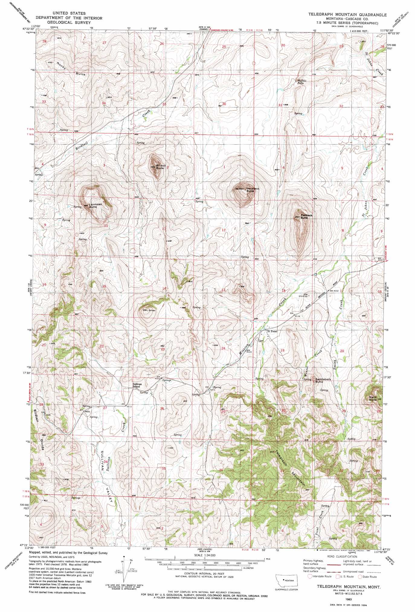
USGS Topo Quad 47111c8 - 1:24,000 scale
| Topo Map Name: | Telegraph Mountain |
| USGS Topo Quad ID: | 47111c8 |
| Print Size: | ca. 21 1/4" wide x 27" high |
| Southeast Coordinates: | 47.25° N latitude / 111.875° W longitude |
| Map Center Coordinates: | 47.3125° N latitude / 111.9375° W longitude |
| U.S. State: | MT |
| Filename: | o47111c8.jpg |
| Download Map JPG Image: | Telegraph Mountain topo map 1:24,000 scale |
| Map Type: | Topographic |
| Topo Series: | 7.5´ |
| Map Scale: | 1:24,000 |
| Source of Map Images: | United States Geological Survey (USGS) |
| Alternate Map Versions: |
Telegraph Mountain MT 1983, updated 1983 Download PDF Buy paper map Telegraph Mountain MT 2011 Download PDF Buy paper map Telegraph Mountain MT 2014 Download PDF Buy paper map |
1:24,000 Topo Quads surrounding Telegraph Mountain
Golden Ridge |
Lowry |
Fairfield |
Fort Shaw |
Sun River |
Bowmans Corners Nw |
Bowmans Corners Ne |
Simms |
Cascade Colony |
Fair Haven Colony |
Bowmans Corners |
Henry Creek |
Telegraph Mountain |
Mount Cecelia |
Cascade |
Comb Rock |
Coburn Mountain |
Mid Canon |
Hardy |
Rocky Reef |
Roberts Mountain |
Wolf Creek |
Craig |
The Sawteeth |
Hound Creek Reservoir |
> Back to 47111a1 at 1:100,000 scale
> Back to 47110a1 at 1:250,000 scale
> Back to U.S. Topo Maps home
Telegraph Mountain topo map: Gazetteer
Telegraph Mountain: Falls
Buffalo Falls elevation 1163m 3815′Telegraph Mountain: Populated Places
Saint Peter elevation 1269m 4163′Telegraph Mountain: Post Offices
Bird Tail Post Office (historical) elevation 1300m 4265′Saint Peter Post Office (historical) elevation 1269m 4163′
Telegraph Mountain: Ridges
Birdtail Divide elevation 1466m 4809′Telegraph Mountain: Streams
Mission Creek elevation 1196m 3923′Smith Creek elevation 1196m 3923′
Weasel Creek elevation 1259m 4130′
Telegraph Mountain: Summits
Birdtail Butte elevation 1504m 4934′Black Butte elevation 1608m 5275′
Fishback Butte elevation 1496m 4908′
Haystack Butte elevation 1510m 4954′
Lionhead Butte elevation 1462m 4796′
Rocky Butte elevation 1429m 4688′
Saddleback Butte elevation 1427m 4681′
Telegraph Mountain elevation 1770m 5807′
Telegraph Mountain: Valleys
Sullivan Valley elevation 1300m 4265′Telegraph Mountain digital topo map on disk
Buy this Telegraph Mountain topo map showing relief, roads, GPS coordinates and other geographical features, as a high-resolution digital map file on DVD: