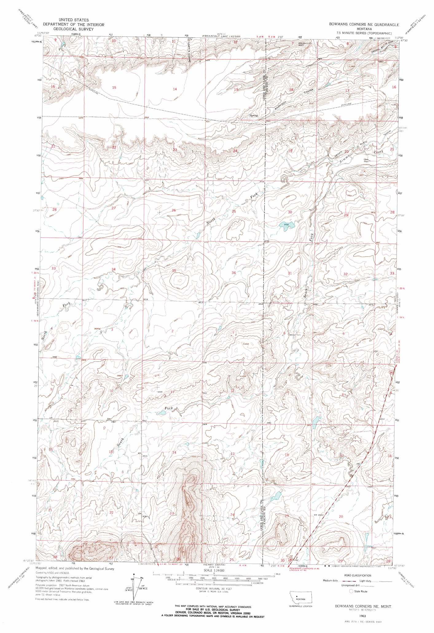
Bowmans Corners Ne Topo Map Montana
To zoom in, hover over the map of Bowmans Corners Ne
USGS Topo Quad 47112d1 - 1:24,000 scale
| Topo Map Name: | Bowmans Corners Ne |
| USGS Topo Quad ID: | 47112d1 |
| Print Size: | ca. 21 1/4" wide x 27" high |
| Southeast Coordinates: | 47.375° N latitude / 112° W longitude |
| Map Center Coordinates: | 47.4375° N latitude / 112.0625° W longitude |
| U.S. State: | MT |
| Filename: | o47112d1.jpg |
| Download Map JPG Image: | Bowmans Corners Ne topo map 1:24,000 scale |
| Map Type: | Topographic |
| Topo Series: | 7.5´ |
| Map Scale: | 1:24,000 |
| Source of Map Images: | United States Geological Survey (USGS) |
| Alternate Map Versions: |
Bowmans Corners NE MT 1963, updated 1965 Download PDF Buy paper map Bowmans Corners NE MT 1963, updated 1965 Download PDF Buy paper map Bowmans Corners NE MT 2011 Download PDF Buy paper map Bowmans Corners NE MT 2014 Download PDF Buy paper map |
1:24,000 Topo Quads surrounding Bowmans Corners Ne
Nunemaker Hill |
Sevenmile Hill |
Freezeout Lake |
Cleiv |
Greenfield |
Gilman |
Golden Ridge |
Lowry |
Fairfield |
Fort Shaw |
Gouchnour Ranch |
Bowmans Corners Nw |
Bowmans Corners Ne |
Simms |
Cascade Colony |
Krone Ranch |
Bowmans Corners |
Henry Creek |
Telegraph Mountain |
Mount Cecelia |
Johnson Mountain |
Comb Rock |
Coburn Mountain |
Mid Canon |
Hardy |
> Back to 47112a1 at 1:100,000 scale
> Back to 47112a1 at 1:250,000 scale
> Back to U.S. Topo Maps home
Bowmans Corners Ne topo map: Gazetteer
Bowmans Corners Ne: Dams
Blooming Creek Dam elevation 1138m 3733′Flicked BIC Dam elevation 1180m 3871′
Bowmans Corners Ne: Populated Places
Olson Place elevation 1122m 3681′Bowmans Corners Ne: Streams
North Fork Simms Creek elevation 1121m 3677′South Fork Simms Creek elevation 1120m 3674′
Bowmans Corners Ne: Wells
20N03W21B___01 Well elevation 1129m 3704′Bowmans Corners Ne digital topo map on disk
Buy this Bowmans Corners Ne topo map showing relief, roads, GPS coordinates and other geographical features, as a high-resolution digital map file on DVD: