Eddy Mountain Topo Map Montana
To zoom in, hover over the map of Eddy Mountain
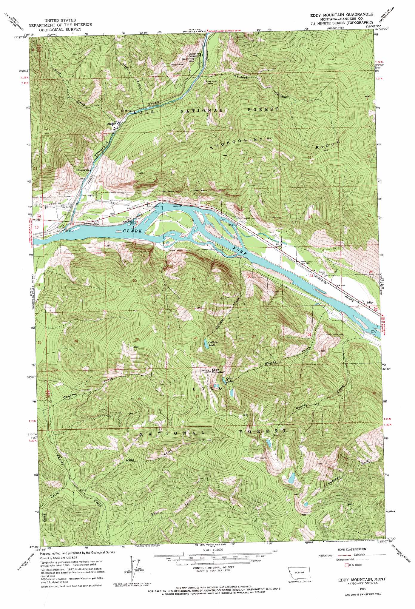
USGS Topo Quad 47115e2 - 1:24,000 scale
| Topo Map Name: | Eddy Mountain |
| USGS Topo Quad ID: | 47115e2 |
| Print Size: | ca. 21 1/4" wide x 27" high |
| Southeast Coordinates: | 47.5° N latitude / 115.125° W longitude |
| Map Center Coordinates: | 47.5625° N latitude / 115.1875° W longitude |
| U.S. State: | MT |
| Filename: | o47115e2.jpg |
| Download Map JPG Image: | Eddy Mountain topo map 1:24,000 scale |
| Map Type: | Topographic |
| Topo Series: | 7.5´ |
| Map Scale: | 1:24,000 |
| Source of Map Images: | United States Geological Survey (USGS) |
| Alternate Map Versions: |
Eddy Mountain MT 1964, updated 1967 Download PDF Buy paper map Eddy Mountain MT 1964, updated 1967 Download PDF Buy paper map Eddy Mountain MT 1999, updated 2003 Download PDF Buy paper map Eddy Mountain MT 2011 Download PDF Buy paper map Eddy Mountain MT 2014 Download PDF Buy paper map |
| FStopo: | US Forest Service topo Eddy Mountain is available: Download FStopo PDF Download FStopo TIF |
1:24,000 Topo Quads surrounding Eddy Mountain
Seven Point Mountain |
Vermilion Peak |
Fishtrap Lake |
Richards Peak |
Cook Mountain |
Belknap |
Mount Headley |
Priscilla Peak |
Calico Creek |
Loneman Creek |
Table Top Mountain |
Thompson Falls |
Eddy Mountain |
Big Hole Peak |
Weeksville |
Haugan |
Deborgia North |
Penrose Peak |
Sunset Peak |
Plains |
Mcgee Peak |
Deborgia South |
Boyd Mountain |
Saint Regis |
Keystone Peak |
> Back to 47115e1 at 1:100,000 scale
> Back to 47114a1 at 1:250,000 scale
> Back to U.S. Topo Maps home
Eddy Mountain topo map: Gazetteer
Eddy Mountain: Lakes
Outlaw Lake elevation 1741m 5711′Quail Lake elevation 1826m 5990′
Tuffys Lake elevation 1984m 6509′
Eddy Mountain: Mines
Copper King Mine elevation 786m 2578′Copper King Mine elevation 801m 2627′
Lower Raven Mine elevation 820m 2690′
Lower Silver King Mine elevation 783m 2568′
Raven Mine elevation 910m 2985′
Raven Mine elevation 963m 3159′
Silver King Mine elevation 891m 2923′
Silver King Mine elevation 902m 2959′
Eddy Mountain: Populated Places
Ashleys Settlement (historical) elevation 740m 2427′Eddy elevation 738m 2421′
Snider elevation 763m 2503′
Eddy Mountain: Post Offices
Eddy Post Office (historical) elevation 738m 2421′Snider Post Office (historical) elevation 763m 2503′
Thompsons River Post Office (historical) elevation 740m 2427′
Eddy Mountain: Ridges
Kookoosint Ridge elevation 1896m 6220′Eddy Mountain: Streams
Cameron Creek elevation 876m 2874′Camp Creek elevation 957m 3139′
East Fork Cherry Creek elevation 1029m 3375′
Goat Creek elevation 749m 2457′
Lynx Creek elevation 973m 3192′
Malone Creek elevation 732m 2401′
Outlaw Creek elevation 732m 2401′
Quartz Creek elevation 732m 2401′
Thompson River elevation 732m 2401′
Eddy Mountain: Summits
Eddy Mountain elevation 2095m 6873′Eddy Mountain: Valleys
Buckeye Canyon elevation 769m 2522′Liver Gulch elevation 764m 2506′
Eddy Mountain digital topo map on disk
Buy this Eddy Mountain topo map showing relief, roads, GPS coordinates and other geographical features, as a high-resolution digital map file on DVD: